
Attractions & Experiences in Eritrea
Asmara – The Modernist City Hang In The Clouds
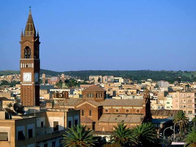
With a perfect climate, remarkable architecture, spotless and safe streets, Asmara ranks among the most pleasant and remarkable capitals on the African continent and in the world. Perched on the eastern edge of the highland plateau, some 2356m above sea level which has an air of being a city above the clouds, Asmara is the largest city in Eritrea with a population of some 420,000.
Asmara stands alone as the only capital, other than Cairo, that is founded on the ruins of culture that gave birth to contemporary life; as such it resembles other capitals that boast great antiquity, such as Rome or Athens. It traces back its origin to 800BC with a population ranging from 100 to 1000 people.
Encouraged by the plentiful supplies of water, the city was later settled in the 12th century by shepherds from Akele Guzay. They founded four villages on the hills for which the site became to be known as Arbate Asmera (Four Villages), from which the name Asmara- literally meaning ‘the forest of flowers ‘ derived. The little village then became a staging post for travelers making the long and arduous journey between the sea and the mountains. Soon it has developed into a small but bustling center. By 1884, the town was home to some 2000 inhabitants and 300 houses, established on the hills where the city’s water reservoirs now stand.
Read More
The town then caught the eye of the Italian general Baldissera and, in 1889, he took it over. Italian architects and engineers got to work and had soon laid the foundations of the new town- Piccola Roma (little Rome), as it was dubbed, was born. It was not just beautiful, but was well planned, well built and, above all, functional and of great aesthetic appeal. In 1897, the first civil governor of Eritrea, Governor Martini, chose Asmara (in preference to Massawa) as the future capital of the Italian East African Empire. Filled with jacaranda and bougainvillea, the city has an almost Mediterranean atmosphere.
Many of the great architectural schools of the period are represented throughout the city: Italian Rationalism, Italian Futurism and Novecento; Streamline Moderne, Bauhaus, Expressionism, Functionalism and Cubism. The old Palazzo Mutton on the Liberation Avenue, now the Wikianos Supermarket, resembled a scaled-down version of the famous Novocomun in Como by Guiseppe Terragni, one of the founding members of Italy’s Gruppo 7 ( the Rationalist movement).
Asmara, the capital of Eritrea, has escaped the ugly, dehumanizing growth that has been inflicted on most other capital cities though out the world in the past 50 years. Isolated for so long, Asmara already has what other cities are trying to recreate. It is probably the only open-minded capital- vibrant and multicultural, harmonious and hospitable, a place of greetings and generosity- in the world. Shops stay open late, bars, cafes and restaurants are full, giant cinemas attract the crowds. Families gather, friends meet, women walk unmolested, children are safe, the visitor can linger and feel at home. These are things of the past in almost all other cities today.
The Roman Catholic Cathedral (The Church of Our Lady of the Rosary) stands about half way along Liberty Avenue, was built in 1923 by the architect Scanavini to a classical Italian design. It is thought to be one of the finest Lombard-Romanesque-style churches outside Italy. The Altar is made of Carrara marble and the baptistery, confessionals and pulpit are carved from Italian Walnut. The painting of Saint Mary by Carlo Maratta di Camerano (1625-1713) was presented by Vittorio Emanuel III, king of Italy. According to the plaque inside the cathedral, Mussolini himself was a patron of its construction. It has a large tower; 25m high, with 8 bells which were placed there in 1925, weighing 100kgs each at the top. The bells, as well as the angel atop the cupola, are said to be made from melted-down metal of Austrian field guns captured at the Battle of Carso. Its prominent bell tower and school buildings were built in the Florentine style and patterned after an Italian Cloister. Much of the church’s interior is made by hand, decorated with large pictures and paintings of angels as well as 14 Stations of the Cross.
St. Mary’s Coptic Cathedral (Enda Mariam Orthodox Cathedral), which stands one street ahead in a more easterly position, was built in 1938 and is a curious blend of Italian and Eritrean Architecture. Its central block is flanked by large square towers. Its twin towers topped with tukuls, could be a new version of Piacentini`s Chiesa di Cristo Re in Rome. Rather garish mosaics of stylised Christian figures are framed vertically above the entrance. Inside the church are a large number of paintings of angels as well as a large painting of St Mary.
The four objects that look like broken elephant tusks suspended in the middle of the compound are century-old bells. These make a surprisingly musical sound when rung (beaten with a stick). There are various kinds of church artifacts, including crosses and ancient biblical manuscripts housed in this century-old building.
Al Khulafa al Rashedin (Followers of the Right Path) lies not far from Liberation Avenue near the fish market, on the Victory Street, is one of Eritrea’s most sacred Islamic shrines that was completed in 1938 by Guido Ferrazza- the grand complex that combines Rationalist, Classical and Islamic styles. The symmetry of the mosque is enhanced by the minaret, which rises at one side like a fluted Roman column above Islamic domes and arches. The mihrab (niche indicating the direction of Mecca) inside consists of mosaics and columns made from Carrara marble.
St George Greek Orthodox Church, established by the Hellenic Community, is a haven of tranquility in the area on the western side of the grain market. It is a pretty church, with an elaborate interior full of paintings, ornate decorations and an interesting ceiling. With its frescoes, carved wood and candles, it could almost be in Greece.
At the western end of Liberation Avenue is the old Governor’s Palace, which was built in 1897 by Ferdinando Martini – the first Italian civil governor of Eritrea. With its pediment supported by Corinthian columns and its spacious, elegant interior, it is thought to be one of the finest Neoclassical buildings in Africa.
Heading east down Liberation Avenue, sits the old Opera House (Cinema Asmara) – one of Asmara`s most elegant early 20th century buildings. Designed by Cavagnari and completed around 1920, this eclectic building combines a Renaissance scallop-shell fountain, a Romanesque portico supported by Classical columns and inside, above multi-tiered balconies, a spectacular Art Nouveau ceiling painted by Saviero Fresa.
Next door is the Ministry of Education. Built during 1930s as the Casa del Fascio (the Fascist Party headquarters), it mixes the Classical with the monumental and fascist. Its massive stepped tower has strong vertical elements, including three gunslit windows. The steps, string courses and mouldings give the building harmony.
Heading east down Liberation Avenue for 100m or so, sits Cinema Impero and Bar Impero, part of a grand Rationalist terrace built in 1938. The imposing Cinema is made up of three massive windows which combine strong vertical and horizontal elements with 45 porthole lamps. In the lobby, all the marble, chrome and glass features are original. The cavernous auditorium seats 1800 people and is decorated with motifs such as lions, nyalas and palm trees depicted in Art Deco style. The Bar Impero, where cinemagoers traditionally enjoyed an aperitif before the film, is also original.
Asmara’s synagogue was built about 1905. Its pediment, Doric columns and pilasters make it very neoclassical. As is usual in Asmara, the wrought-iron gates are handcrafted.
Opposite Wikianos Supermarket is the Municipality Building. Though built in 1950s, it is firmly Rationalist. The two geographic wings are stripped Palladian style, and are dominated by soaring central tower. The windows are beautifully detailed. The Mai Jhah Jhah fountain is one of the most elegant pieces of architecture in Asmara. This cascades down the hillside in a serious of rectangular steps. Above the fountain is the attractive suburb of Gezzabanda, which is full of impressive villas, and Beverly Hills cafe with its jet engine espresso machine.
Just opposite City Park and just off Liberation Avenue, is Cinema Odeon with its authentic Art Deco interior. The box office, bar, beveled mirrors, black terrazzo and Deco Strip lights are a good introduction to the large auditorium. Opposite to the cinema is the Bristol Hotel. Built in 1941, the hotel, with its central stairwell tower surmounting geometric wings, is an example of classic Rationalist design. The strip-course separates the top-floor windows from the well-proportioned and well-made shutters, and the plain concrete balconies below.
The Capitol Cinema, on Revolution Ave, north of the Governor’s Palace, was built in 1937, and its massive horizontal elements and sweeping curves are typical of the Expressionist movement. According to Professor Sandro Raffone, of Naples, the streamlined Cinema Capitol is strongly influenced by Mendelsohn, the German Expressionist who designed the revolutionary Einstein Tower in Potsdam, Germany.
Built in the 1930s, the Selam Hotel was one of a chain constructed by the Italian company Compagnia Immobiliare Alberghi Africa Orientale (CIAAO). Interesting interior details include the Arts and Crafts serving cabinets and the disc type lamps in the dining room, the old murals and the purple beehive lamps in the rear courtyard.
The National Museum is located next to Salem Hotel. It includes exhibits on the ethnic groups of Eritrea – national dresses of different nationalities, paintings of the nine ethnic groups, cooking pots, wooden pillows etc, the main archeological sites of the country and the struggle for independence.
The facade of the extraordinary Bar Zili, at the junction of Knowledge St and Martyrs` Ave, looks like a 1930s radio. The porthole windows and nautical balconies are separated into sections by mock-marble columns.
Perhaps the best-known building in Asmara is the Fiat Tagliero building. This futuristic aeroplano (aeroplane), in the southwest of the city, was built in 1938 by engineer Pettazzi. The central tower with its glass cockpit is similar to many structures in Miami, USA. The story goes that after the concrete has been poured, Pettazzi`s workers refused to remove the shuttering supports of the cantilevered wings for fear that the whole thing would collapse. Standing on one of the wings, with a revolver against his head, the engineer vowed he would shoot himself if his masterpiece didn’t hold together.
To the west of the city, above the Orota Referral Hospital, the Italian Forto Baldissera (home to the Ministry of Information) sits on raised ground and has good views over the city. Next to it is St Michael Church and further to the west is Kagnew Station, built as an American military base and easily identified by the piles of military detritus behind it (generally known as the tank cemetery). The incredible Italian Cemeter is also beside St Michael’s church and well worth a visit for those interested in sculpture or Art Deco. Other cemeteries include The British Cemetery, located on the Asmara Massawa road, 2km from the center dating from 1941. Interred here are 280 men killed during the African campaign. There is also a Hindu burial ground for the Indian soldiers fighting alongside the British.
The Shuq (Market) is one of Asmara`s major attractions and an essential part of any walking tour in Asmara. The largest market is in Eritrean Square and sells vast array of beans, pulses, grains, fruits and vegetables. The mini-mills around the outside of the market are worth taking a look at as the workers separate, sieve and prepare the various grains to make flour, with remarkable efficiency. The souvenir market (Edaga Lakha), the market behind the central mosque, is a great place to browse too, and is more interesting than the shops in town. One can find among other things, wicker basket, wooden masks, mats, pottery items, musical instruments, decorated gourds and skin paintings. Another market worth going for the sake of browsing is Medeber market (from the Tigrinya word for ‘together’) in the northeast corner of the town, is like an open-air workshop where absolutely everything is recycled. The air is filled with hammering, sawing and cutting; old tires are made into sandals, corrugated iron is flattened and made into metal baskets, and olive tins into coffee pots and tiny scoopers. It is a salutary lesson in waste and resource management.
The recently resurrected railway, which was begun 110 years ago and which climbs from sea level to 2400m in just 117km, is definitely worth a visit. The steam engines have been completely stripped down to their bare parts, cleaned and rebuilt by the veterans who had worked on the line during the Italian period. The service is running again from Asmara down to Massawa. For railway enthusiasts, looking for a new adventure, the railway promises to provide one of the world’s most spectacular and unusual journeys.
Massawa – The Pearl Of The Red Sea
The very name conjures up an air of mystique and hidden delights. Massawa! City of islands and the ‘Pearl of the Red Sea, a city which for centuries has been one of the regions most important ports, and which once, more recently, was the Italian capital of Eritrea. a city whose charm has been influenced over the past centuries by the Portuguese, the Arabs, the Turks, the Egyptians, the British, the Italians and, most of all, the Eritreans themselves.
Massawa’s development was initially influenced by the Arabian Peninsula. Massawa was turned into a renowned center of intellectual and artistic skills, and this is reflected in the city’s architecture. New ideas implemented over the years by a host of different nationalities, until the British, determined to stamp out the growing French influence in the region took Eritrea from the Egyptians in 1882 and then gave the territory to the Italians in 1885. Massawa thus became the headquarters of the embryonic Italian colony, until the permanent capital was created at Asmara in 1887.
Read More
To supply their new capital from Massawa, the Italians initially used a cable car, the longest in the world to winch up provisions from the port on the shore to 2500m below. As the new capitals population exploded, however, this became impractical, and they installed a railway line, whose construction was beset with engineering difficulty because of the escarpment between the port and the capital, and it finally reached Asmara in 1922. For almost half a century the railway moved goods and people across Eritrea. It took 6 hours from Massawa to Asmara at an average speed of 19km an hour up the escarpment. The line opened up new markets for farm produce, and towns such as Nefasit, Keren and Agordat prospered; as such Massawa prospered as never before. Up until the 1960s, Massawa was by far the largest, the safest and the most lucrative port on the East African littoral.
During the wars that have befallen Eritrea since, the railway was dismantled piecemeal by the British. Beginning from 1993, veteran railway workers were enlisted to repair the old locomotives and railway stock and began relaying the tracks, starting at Massawa. After years of back breaking work and true grit, the railway is now once more functional.
With its low, whitewashed buildings, porticoes and arcades, Massawa has an Arab feel to it, reflecting its century-old connection with Arabia across the other side of the Red Sea. Massawa`s natural deep harbour and its position close to the mouth of the Red Sea and Indian Ocean have long made it the target of foreign powers. It was occupied by the Portuguese, Arabs, Egyptians and Turks; they all but handed it over to the Italians in 1885. Trade in Massawa flourished throughout these occupations- everything from slaves, peals, giraffes and incense to Ostriches and myrrh passed through this port.
Its buildings reflect its history of occupation. The Ottoman Turks, who occupied the city for nearly 300 years, had the biggest influence on the architecture. Their successors, the Egyptians, also left a legacy of buildings and public works, including the elevated causeways, an aqueduct and the governor’s palace. In 1885 the Italians occupied Massawa and the town became their capital until it was superseded by Asmara in 1897. During this time, many of the fabulous villas were built.
Massawa consists of two islands, Tiwalet and Old Massawa(Wishti Batzie). The mainland area, called Old Massawa, is largely residential, and a long causeway connects it to Tiwalet Island, which is home to some old villas, the administrative buildings, and a few of the town’s smarter hotel. The cause way that connects the two islands was built by the Swiss adventurer Werner Munzinger in the 1870s.
The two islands are now linked to the mainland by the causeways – that form Massawa are intriguing and attractive. As you come over the cause way to the Taulud Island, a broad sweep of white, arcaded palazzi (palaces) stretches over before you. On the corner, opposite the transport office, the Hotel Savoiya, with its long gallery, has a great view over the harbour. Near the port entrance is a good example of 17-century coral-block house. For centuries coral was the local building stone. Heading back toward the causeways, you will pass the large Banco d’Italia, an exact copy of its 1920s original and a mishmash of architectural styles, including Gothic windows and towers.
In a square beyond the Banka is a rare example of a Turkish house with a doomed roof, now impressively restored.  Shaafi Mosque – one of the oldest mosques in Africa, by the port entrance, was founded in the 11th century but rebuilt several times since, is worth a quick look. An ancient house across of Mammud Mohammed Nahari is there with soaring Ottoman-style windows on every side. Opposite the house is the 16th- century tomb of Sheikh Durbuh enclosed in a small garden. Nothing is so far known about the Sheikh. Around this area are some large and ornate18th-century Armenian and Jewish merchants houses.
About 150m from the port entrance, is the house of Abu Hamdum, with its magnificent mashrabiyya (trellised) balcony, which allowed cool breezes to enter and the air inside to circulate. It is a great example of Turkish Ottoman architecture. Nearby is Piazza degli Incendi (meaning ‘Square of the Fire’, after it was the scene of a great fire in 1885), in the center of which is the Sheikh Hanafi Mosque. At over 500 years old, this mosque is one of the oldest surviving structures in the city. Seikh Hanafi was a great teacher, who funded his students studies in Egypt. The walls of the courtyard are decorated with stuccowork and inside hangs a remarkable chandelier from the glassworks of Murano near Venice in Italy.
Just north of the gate of the Dahlak Hotel is the old Imperial Palace overlooking the harbour. The original palace was built by the Turkish Osdemir Pasha in the 16th century. The present building dates back from 1872, when it was built for the Swiss adventurer Werner Munzinger- then employed for the Khedive of Egypt. The palace also contains the first elevator in Eritrea. Look out for the beautifully carved wooden doors, said to come from India. Some of the villas near the shore are exceptionally beautiful, combining elements of Art Deco style with traditional Moorish arcades and huge mashrabiyya balconies. After about 500m is Orthodox St Mariam Cathedral, which sits at the end of the causeway from the mainland was built in 1953 by the Orthodox Church. Opposite to the cathedral is the massive tank monument to the Eritrean Struggle for Independence. Three huge tanks are preserved where they stopped in the final assault on the town in 1990, and now stood on a black marble base. South of the cathedral is the famous Red Sea Hotel, scene of many glamorous balls in 1960s and 1970s.
The coast of Massawa is also renowned for shipwrecks, some of them in very good condition. These include wrecks of World War II Italian warships, frigates and even tanks. Some of them lie only 3m below the surface while some are far deep as 4km. Life under the sea, off Massawa east coast opens up a veritable treasure chest of colorful fish and exotic corals. Some distinctive forms are fan corals or Gorgonacea, tree corals of Nepthiidea family, fire corals or Millepora et cetera.
The Dahlak Islands
Scattered over a vast area of the Red Sea like a string of pearl upon the azure, translucent waters of the Red Sea, more than 350 Eritrean islands, among which more than 200 islands belong to the Dahlak Archipelago, remain one of the last great unspoilt destinations in the world.
The impact of the Red Sea on the history and development of Eritrea has been all important. The name Eritrea derives from the ancient Greek word for red, which was named after the waters of the Erythrean Sea. Today, it provides modern Eritrea with its vital sea links with the outside world, as well as a welcome place of recreation for Eritreans and visitors alike.
The abundance of fish life, the wonderful corals and unspoiled waters have made the Dahlaks a scuba-divers paradise, an aquatic wonderland.
Read More
Pearl fishing has flourished around the Dahlaks since the time of the ancient Egyptians, who held influence over the islands. Later they fell under the control of the Ottoman Empire, when the largest island, Dahlak Kebir– some 60km across, was the chief port for pearl fishing in the southern part of the Red Sea. It has a Necropolis with Kufic inscriptions, as well as ancient water cisterns.
Early inhabitants of the Dahlak dealt with the problem of drinking water by carving large cisterns out of the rock, each of which contained a days ration for the settlement. One cistern was carved for every day of the year, an extraordinary triumph of human ingenuity over this harsh environment, but for some reason they fell into disuse centuries ago.
Of the 1,000-plus species or subspecies of fish known to inhabit the Red Sea, some 15% are not found anywhere else. Some corals and echinoderms, such as certain star fish, are only found here. Current records for coral fish include 40 species in 24 families on stresses coral patches near Massawa and over 250 species in 49 families on outer coral reefs such as angelfish, parrotfish, barracudas, pipefish, surgeonfish, sharks, tuna, caranx et cetera.
Off the leeward coast of Dahlak Kebir, at the mouth of the Gulf of Zula, lies the Island of Dissei, formed by a narrow ridge of little volcanic hills which tapers off at either end. Disseis beaches are so quiet and remote that when the islands only village comes into view in a wide, sandy bay, it appears like a settlement of survivors from a long-forgotten shipwreck. Huts constructed from driftwood and strung with old fishnets strengthen the impression that this is a community of several dozen Robinson Crusoes.
There is a good chance, too, of seeing turtles a notably the hawksbill, leatherbacks and green species and the sparsely populated Dahlaks offer a haven for these threatened animals when they breed. Female turtles come ashore to lay their eggs on the beach and bury them in the sand. When hatched the babies make their way to the sea to fend for themselves.
Mantarays, which have wing spans measuring up to several metres, occasionally leap clear of the water and flap down on the surface. The reason for this acrobatics is a mystery, but it could clean themselves of parasites. The fins which form horns in front of the eyes and on either side of the mouse, the dark back and long whip-like tail give the manta a somewhat sinister appearance. But they only fed on small shoaling fish and they behave sweetly when a diver hitches a ride on their shoulders.
Pods of Dolphins sometimes appear, swimming playfully alongside the boat, including the humpback, bottlenosed, spinner and common types. Whilst whales are rarely observed in the Red Sea, another significant mammal species found in the Dahlaks is the dugong, or sea cow. This creature, which gave rise to fishermen tales about mermaids, is rarely seen. It is grayish, cylinder-shaped, up to four metres long, and can weigh up to 900 kilos.
Across from Dissie lies the Island of Madot. At certain seasons, tens of thousands of seabirds come here – and many other islands in the Dahlaks to breed.
If you swim at night it is possible to observe another incredible wonder of nature. As you move through the dark water, an aura of greenish sparkling light explodes around your fingers and limbs. This amazing light show, called bioluminescence, is produced by tiny living creatures. The Dahlaks are indeed a world of their own.
With its expensive coastline, numerous islands and relatively calm waters with steady winds in some areas, the shore and marine environment of the country offers significant potential for water based tourism.
Scuba Diving & Snorkelling – The Dahlak islands, are one of the most rewarding places for these activities.
Shipwrecks off the Massawa Coast – Twelve wreck sites have been located in the Red Sea. Some of them lie only 3m below the surface while some are as deep as 40m down under. These include wrecks of the World War II Italian warship such as the Nazario Sauro, freighters and even army tanks have been observed.
Water Skiing, Surf-riding and Sailing there is a great potential for Water-Skiing, Surf-riding and Sailing.
Beach Recreation & Swimming The waters of the Eritrean coast are shallow and relatively safe for swimming. There are beaches on both the mainland coast and islands, very suitable for recreation and family retreat.
OTHER PRINCIPAL SITES IN ERITREA
HAM – Debre Libanos Monastery dating back to the 6th Century AD is located in Ham. One can see the graves, mummies and religious artifacts dating back to the 4th century AD.
RORA BAKLA & RORA HABAB – Ancient site of ruins, stele, and caved lion statues plus etching of the animals are some of the sites worth visiting.
Ancient Port Of Adulis
Lying 59km to the south of Massawa, near the village of Foro, is the ancient ruins of Adulis. Once numbering among the greatest ports of the ancient world, Adulis was the site of large and elegant buildings and bustling international port. Inhabited since at least the 6th century BC, the site is the oldest in Eritrea.
Adulis’ importance lay in its port, and by the 3rd century AD the port had grown to become one of the most important on the Red Sea. Trade of this time flourished from the Mediterranean all the way to India. Its heyday came during the 3rd and 4th centuries AD, and then it went into decline, before a brief revival in the 7th century. The town supplied all the major towns: Kohaito, Metera and Keskese.
Adulis has been excavated, and its links with the Roman, Egyptian and Greek empires and with distant ports are shown by broken pottery made by the many manufacturing methods that can be used to date the past and its events.
The most recent excavation, since Peribeni`s first major study done in 1907, was carried out by Anfray in the 1970s. It has become obvious from these excavations that the town was very significant, sitting astride major ancient trade routes from Egypt to the Indian Ocean.
Vast quantities of artifacts have attested to the richness of life in the town: gold and silver coinage, glass, marble, decorated pottery, et cetera. Most of the unearthed ruins are constructed in black basalt; there are tombs, a palace, what is possibly an 8th century Christian church and an earlier temple for the worship of the sun.
Adulis` importance was eclipsed in the 7th century, probably by a combination of Arab raids and the port silting up. It is hoped that Adulis will eventually be declared a UNESCO World Heritage Site.
The Gulf Of Zula
The Gulf of Zula is a deep cleft in Eritrea’s coastline, plunging 50 kilometers southwards and flanked by the massive mount of Gheddem and its peninsula to the west, and by the Buri Peninsula and the peaked island of Dissei to the east. This is the birthplace of the Great Rift Valley on the African continent.
At the southern tip of the gulf, near Irafaile, is some hot springs small cracks in the rocks whose vapour, the local people believe, is medicinal; they crouch over the holes to inhale it.
On the hillsides above the springs might be found jet-black pieces of stone that resemble glass called obsidian, or volcanic glass, this material was used to make early tools. Pieces were carefully flaked from the original lumps, known as cores, to produce edges as sharp as razors for use in skinning animals, cutting up the flesh for meat and the sinews for rope, and scraping the hide to make water containers, clothing and other useful items. This glass was probably an important trade commodity for the local people, for the shaped and used flakes can be found on many of the offshore islands and along the coastline, where no such rocks exist naturally.
Above all this lies a massive volcanic crater, with two subsidiary cones to its south. These ash cones might have erupted violently at some time during the past 20 million years, a period during which explosive seismic activity split the block of continental Africa to form the Great Rift Valley.
Distant hills fringing the Gulf are of more ancient origin, probably formed as the massive uplifted area of volcanic rocks was established 40 million years ago. Over the millennia, tons of highland soil and rock have been washed down during each rainy season, gradually working their way to the sea.
Today, the foreshore and dry gully mouths abound not only in highland rocks and quartz crystal yellowed by iron salts but also in evidence of man presence; a careful search might reveal a goat skull or a mineralized camel tooth, or even pottery shreds, smooth-edged from water wear. Deeper digging might even expose ancient stone hand-axes, backed flakes and worked implements from campsites where ancient peoples lived as they watched the sea and gathered its bounty, or hunted wild animals in the hinterland.
The Gulf continues further inland and the Rift Valley drops again, as deep as 120 meters below sea level in the Danakil Depression. Extreme heat and evaporation, together with bands of rock and low hills, prevent the sea from flooding the area, which is a fantastic inferno of sulphur springs, active volcanic vents that glow by night, salt lakes, and dry, searing heat – truly the devils kitchen!
In more recent times, the Gulf has undoubtedly played its part in history, through the influence of the Romans, the Greeks, the Persians, the Turks, the Egyptians, the Italians and the British. Links with an increasingly civilized world were via the sea, the closest possible harbour being in the Gulf of Zula.
A few decades later, the first Italians appeared in the scramble for new lands and empires in Africa. In time, they began to pay attention even to the arid lands of Gulf, and the irrigation potential of the Zula area was explored. A large earth and stone dam was built across the Haddas River, upstream of the site of Adulis. Below, on the plain, massive earth bunds were raised and irrigation ditches installed. By the start of the First World War, a seaplane port and an airstrip had been developed at the site of the Napier jetties. It is said that vegetables and produce from Zula irrigation were flown out through here, and that mail and other communications passed through the site.
The dam soon silted up, and eventually flood waters found a way beneath the wall. Coupled with the defeat of the Italians by the British in 1941, the dam and irrigation works returned to the soil. The Italians departed and the British took over for a short period.
Zula today has a peaceful but hot and dusty environment. The areas around are thriving, irrigation works are producing experimental crops at Foro and new villages are springing forth between Massawa and the southern tip of the Gulf.
Denakil Depression
The Denakil Depression is one of the lowest points on the earth not covered by water. One of the most forbidding and inhospitable landscapes in the world, it is starkly dramatic yet with a beauty and appeal all of its own.
This sun-scorched bowl was created in the long-distant past by the massive movements in the earth’s surface which formed Africa’s Great Rift Valley. Just 50 kilometers away are 1,348-metre-high Ramlo forms an impenetrable barrier between the Red Sea and the land mass, its northern flanks guarding the Massawa-Assab road.
Day and night the heat in the Denakil Depression in fierce some, sapping all energy and seeming to suck the body dry. It seems as if nothing could survive here and yet it was not always so, for this was the crucible where humankind, Homo sapiens, was forged. Relatively recent excavations have unearthed vital clues, including the oldest fossil bones yet discovered of human ancestors.
Around three million years ago, when the climate of Denakil was more hospitable, lived the precursors of the human race. Named Australopithecus Afarensis, their remnants survive today in hundreds of bone fragments. An Italian team of mineral prospectors discovered early hominid remains in the Denakil in the early 1990s.
Today few creatures live in the Depression itself, which is commonly referred to by local people as ‘dead land’. But the lowlands and highlands of Denkalia form the Nomads Land of the Afar, a proud and hospitable people, despite their fiercesome reputation. Salt traders and nomadic herdsmen have learned to live and thrive in this unyielding environment.
Few trails penetrate this wilderness and only one leads the 700 kilometers from Massawa to Assab, cutting inland from the coast to wind through the gaunt mountain barrier, cut by numerous valleys carved out by seasonal rivers, that isolates the Danakil Depression.
The conceived picture of Denkalia is that of vast, flat, sandy area, the desert of European imagination. In reality, it is magnificent for its range of contrasts. Never is the scenery of this desert monotonous; rocky mounds and headlands of lava rock give way to a vast, sandy plain, with clumps of feathery golden grasses and low acacias.
Turing inland, there are vast reefs of gypsum, blinding white in the sun, and like a ghostly ocean in the moonlight. These jut out into swirls of brown sand or black, boulder-strewn lava flows as the road begins its descent into the Danakil Depression.
The land falls away in gentle undulations, punctuated by small volcanic hills, to the lowest point, some 110 meters below sea level. At this altitude the earth’s outer crust seems to have peeled away and the land is dotted with shifting salt sands.
The Eritrean Gateway to the Danakil Depression is at a bleak little village called Badda set some 50 meters below sea level. Badda to the Afar, entirely at home in this harshest of lands, means ‘dead sea’. When traveling great distances the nomads carry a chunk to lick, or make a cake of grain, camel milk or salt – which is essential for the survival of people and animals apart from its valley as a commodity for trading.
The main attraction of Badda is the beautiful Lake Badda, formed in the crater of an extinct volcano, Abuhibet. The lake a turquoise jewel 50 meters below, is about 400 meters in diameter and, according to an Old Italian survey, is 100 metres deep. The opposite wall of the crater is solid lava. All this water around Badda has allowed some game to survive and at night Asiatic jackals come close to the village, calling their ghostly, wailing voices as they hunt or scavenge around the huts. Besides, Camels, donkeys and Ostriches still thrive and roam around this region.
The railway into this desolate region, built in 1912 to shuttle potash mined in Dallol to the coast, fell into disuse when the Italian empire collapsed. Even some of the old water cisterns along the roadside remain: these were constructed in 1930s, at 5km intervals, to facilitate road travels. In the derelict rail yard, scattered with girders and old trolleys, one can only admire the enterprise and optimism of those who dreamt up and constructed such a scheme.
You may feel that you are on the surface of the moon or on a frozen sea. Rock formations loom above you, looking like huge waves suddenly stopped and frozen. The sun burns without mercy; a hot strong wind always blows and air boils and whizzes.
Many may consider a desire to travel to the Danakil area a voluntary trip to the ‘hell’, but if you love nature, the many faces of the desert and the warmth of unfamiliar peoples, then this is the route for you. The sense of exploration is real and the journey is likely to be the most memorable and challenging of your life. Since Dankalia is also territory of the legendary Afar people, described as one of the fiercest tribes on the earth- but are no longer to be feared, a journey into this region gives a fascinating glimpse into their lives.
Kohaito Archeological Site
In the 2nd century AD, the famous Egyptian geographer Claudius Ptolemy made reference to an important ancient town named Koloe. It has long been thought that( Qohaito Kohaito was equivalent to Koloe. But even if it is not (some modern scholars favor nearby Metera), Kohaito importance in the ancient world during this time is obvious.
Very little is known about the exact history of the settlement. A few ancient chronicles record that Kohaito was still flourishing in the 6th century AD. However, like Adulis and Metera, it then vanished very suddenly in the next one or two hundred years.
Kohaito, which lies at high altitude of 2700m, once may have served as a kind of summer retreat for the rich merchants from nearby towns. The traces of cultivated areas found between the buildings have led to the belief that Kohaito was once a garden city.
Lying some 121km south of Asmara, Kohaito’s impressive ruins are spread over a large area measuring 2.5km wide by 15km long. As much as 80 to 90% of the ruins remain unexcavated. In 1996 and 1997, a German expedition surveyed both Kohaito and Metera.
A short walk from Kohaito takes you to the edge of a vast canyon that drops away dramatically. The views of the surrounding mountains, including Mt. Ambasoira (3013m) to the south (the highest peak in Eritrea), are stunning. Far below, you can make out the terraced fields and tiny tukuls of seemingly to totally inaccessible Saho settlement.
Among Kohaito’s most important ruins is the so-called Temple of Mariam Wakiro that was built on a rectangular plan on a solid platform, and may have been the site of a very early Christian church or even a pre-Christian temple. In the local language this site has long been referred to as ‘abode of the prestigious one’.
About a kilometer to the north of the ruins of Mariam Wakiro, lies a tomb discovered in 1894 nicknamed ‘Meqabir Ghibtsi’ or the Egyptian tomb because of its impressive size. The tomb faces east, overlooking the Hedamo River. Rectangular in shape and built with large blocks of stones, its most distinctive features are the two quatrefoil (flower-shaped) crosses carved on the inside walls.
Shapira Dam, measuring 67m long and 16m deep, is constructed of large rectangular blocks of stone that measure close to 1m by 0.5m, is Kohaito’s greatest claim to fame. The masonry is quite beautifully dressed- one of the reasons perhaps for the dam’s incredible longevity.
For around 1000 years, it has served the local Saho people as the main source of water. Following recent investigation carried out by the German team, this water cistern date back to around 1 Century AD and even before this period. On one of the walls inside the dam are some inscriptions in ancient Ge’ez, made up of 79 words, is the longest yet found in Ge’ez.
At Iyago, near Kohaito, south-east of Mt Faquiti, an open shelter around 9m long is covered in rock paintings dating from approximately 4000-5000BC. Nearly 100 figures painted in ochre, black and reddish-brown adorn the rock face, depicting cattle, antelopes and perhaps lions. Other rock shelters in the area include Ba’atti Abager, Zebanona Libanos and Mai Ayni, where figures include warriors with long spears and oval-shaped shields, and wearing animal skins seem to be indulging in a ritual dance.
Around Qohaito (Kohaito)
Matara (Metera)/Belew Kelew
Situated 20km south of Kohaito, house some of Eritrea’s most important historical sites. Like Kohaito, Matara (also called Metera) flourished in the 6th century AD. The scattered ruins testify to the existence of a once large and prosperous town.
Metera is important for three main reasons: for its age some of it, from about 5th century BC; for its huge size– it spreads over at least 20 hectares and is known among locals as Belew-Kelew, it is much the largest site after Adulis; and for its unusual character- it is the only place where a large bourgeois community is known to have thrived.
One of Metera’s most important objects is its enigmatic stele. Unique in Eritrea, the stele is known for its pagan, pre-Christian symbol of the sun over the crescent moon- a south Arabian divinity, engraved on the top of the eastern face; and it faces eastward. Standing 2.5m tall, the stele has an inscription near the middle in Gee’z. An unknown king dedicated the stele to his ancestors who had subjugated the ‘mighty people of Awanjalon, Tsebelan’.
Metera’s discovery came in 1868, when Frenchman Denis de Rivoire reported its existence. In 1903, an Italian officer made a few amateur excavations in two places. The first scientific survey was carried out by the German Expedition in 1906. In 1959, the French archeologist Francis Anfray began a major excavation of the site. From 1959 to 1965, various sites were excavated. A large mould located 100m north-west of the stele revealed a big, central building- perhaps a royal palace or a villa- attached to an annexe of living quarters. A huge wall surrounds the whole complex. Several burial chambers were found in the larger building; in one of them, the skeleton of a chained prisoner was discovered. Between 1961 and 1962, a large, square, multiroomed complex built on a sturdy podium and a tomb chamber were unearthed.
Anfray’s excavations also uncovered four large villas, some smaller houses, three Christian churches and a residential quarter- perhaps for the common people.
Objects unearthed at Metera in the last 50 or more years include some beautiful and amazingly well-preserved gold objects- two crosses, two chains, a brooch, necklaces and 14 Roman coins dating from between the 2nd and 3rd century AD- found in a bonze vase. Many household items including bronze lamps, needles and daggers, Mediterranean amphorae, and the remains of large marble plates were unearthed.
Only tiny part of Metera has been excavated. Big moulds lie tantalizingly untouched all around the ancient people tomb hidden somewhere among the rocks still awaits exploration, and may yield a remarkable finds.
One of the more remarkable things, here and at the other Archeological sites, is that the cement that binds the bricks show no sign of weakening even after some 1,400 years, a fact which is unlikely to be true of the stuff manufactured today. Metera has been identified by the historian Kobishchanov as the ancient city of Koleo, which currently seem to be more acceptable theory that the one put forward in the 1890s by Bent, that Koleo was Kohaito.
TOCONDA – lie 4km south of Adi Keyh in a wide valley. The ground is littered with potsherds, broken pillars and chiseled stones. Close to the dirt road there are two pillars: one standing, another with a curious rounded head. On a hill west of the site, there is an early inscription curved on a large basalt rock.
Keskese – lies in a small valley 128km south of Asmara. This huge, unexcavated site is considered exceptional for its pre-Christian and pre-Islamic remains, which include the ancient tomb of a local prince or lord. Lying among the barley fields like elongated, upturn boats are various huge monoliths, including one measuring a giant 14m long. Some stelae bear ancient inscriptions in Ge’ez; from their style, it is believed that they are at least 2500 years old. Elephants are offered as the most likely explanations from the way the immense stones were transported.
Kohaito Archeological Site
In the 2nd century AD, the famous Egyptian geographer Claudius Ptolemy made reference to an important ancient town named Koloe. It has long been thought that( Qohaito Kohaito was equivalent to Koloe. But even if it is not (some modern scholars favor nearby Metera), Kohaito importance in the ancient world during this time is obvious.
Very little is known about the exact history of the settlement. A few ancient chronicles record that Kohaito was still flourishing in the 6th century AD. However, like Adulis and Metera, it then vanished very suddenly in the next one or two hundred years.
Kohaito, which lies at high altitude of 2700m, once may have served as a kind of summer retreat for the rich merchants from nearby towns. The traces of cultivated areas found between the buildings have led to the belief that Kohaito was once a garden city.
Lying some 121km south of Asmara, Kohaito’s impressive ruins are spread over a large area measuring 2.5km wide by 15km long. As much as 80 to 90% of the ruins remain unexcavated. In 1996 and 1997, a German expedition surveyed both Kohaito and Metera.
A short walk from Kohaito takes you to the edge of a vast canyon that drops away dramatically. The views of the surrounding mountains, including Mt. Ambasoira (3013m) to the south (the highest peak in Eritrea), are stunning. Far below, you can make out the terraced fields and tiny tukuls of seemingly to totally inaccessible Saho settlement.
Among Kohaito’s most important ruins is the so-called Temple of Mariam Wakiro that was built on a rectangular plan on a solid platform, and may have been the site of a very early Christian church or even a pre-Christian temple. In the local language this site has long been referred to as ‘abode of the prestigious one’.
About a kilometer to the north of the ruins of Mariam Wakiro, lies a tomb discovered in 1894 nicknamed ‘Meqabir Ghibtsi’ or the Egyptian tomb because of its impressive size. The tomb faces east, overlooking the Hedamo River. Rectangular in shape and built with large blocks of stones, its most distinctive features are the two quatrefoil (flower-shaped) crosses carved on the inside walls.
Shapira Dam, measuring 67m long and 16m deep, is constructed of large rectangular blocks of stone that measure close to 1m by 0.5m, is Kohaito’s greatest claim to fame. The masonry is quite beautifully dressed- one of the reasons perhaps for the dam’s incredible longevity. For around 1000 years, it has served the local Saho people as the main source of water. Following recent investigation carried out by the German team, this water cistern date back to around 1 Century AD and even before this period. On one of the walls inside the dam are some inscriptions in ancient Ge’ez, made up of 79 words, is the longest yet found in Ge’ez.
At Iyago, near Kohaito, south-east of Mt Faquiti, an open shelter around 9m long is covered in rock paintings dating from approximately 4000-5000BC. Nearly 100 figures painted in ochre, black and reddish-brown adorn the rock face, depicting cattle, antelopes and perhaps lions. Other rock shelters in the area include Ba’atti Abager, Zebanona Libanos and Mai Ayni, where figures include warriors with long spears and oval-shaped shields, and wearing animal skins seem to be indulging in a ritual dance.
Around Qohaito (Kohaito)
Matara (Metera)/Belew Kelew
Situated 20km south of Kohaito, house some of Eritrea’s most important historical sites. Like Kohaito, Matara (also called Metera) flourished in the 6th century AD. The scattered ruins testify to the existence of a once large and prosperous town.
Metera is important for three main reasons: for its age some of it, from about 5th century BC; for its huge size– it spreads over at least 20 hectares and is known among locals as Belew-Kelew, it is much the largest site after Adulis; and for its unusual character it is the only place where a large bourgeois community is known to have thrived.
One of Metera’s most important objects is its enigmatic stele. Unique in Eritrea, the stele is known for its pagan, pre-Christian symbol of the sun over the crescent moon- a south Arabian divinity, engraved on the top of the eastern face; and it faces eastward. Standing 2.5m tall, the stele has an inscription near the middle in Gee’z. An unknown king dedicated the stele to his ancestors who had subjugated the ‘mighty people of Awanjalon, Tsebelan’.
Metera’s discovery came in 1868, when Frenchman Denis de Rivoire reported its existence. In 1903, an Italian officer made a few amateur excavations in two places. The first scientific survey was carried out by the German Expedition in 1906. In 1959, the French archeologist Francis Anfray began a major excavation of the site. From 1959 to 1965, various sites were excavated. A large mould located 100m north-west of the stele revealed a big, central building- perhaps a royal palace or a villa- attached to an annexe of living quarters. A huge wall surrounds the whole complex. Several burial chambers were found in the larger building; in one of them, the skeleton of a chained prisoner was discovered. Between 1961 and 1962, a large, square, multiroomed complex built on a sturdy podium and a tomb chamber were unearthed. Anfray’s excavations also uncovered four large villas, some smaller houses, three Christian churches and a residential quarter- perhaps for the common people.
Objects unearthed at Metera in the last 50 or more years include some beautiful and amazingly well-preserved gold objects two crosses, two chains, a brooch, necklaces and 14 Roman coins dating from between the 2nd and 3rd century AD- found in a bonze vase. Many household items including bronze lamps, needles and daggers, Mediterranean amphorae, and the remains of large marble plates were unearthed.
Only tiny part of Metera has been excavated. Big moulds lie tantalizingly untouched all around the ancient people tomb hidden somewhere among the rocks still awaits exploration, and may yield a remarkable finds.
One of the more remarkable things, here and at the other Archeological sites, is that the cement that binds the bricks show no sign of weakening even after some 1,400 years, a fact which is unlikely to be true of the stuff manufactured today.Metera has been identified by the historian Kobishchanov as the ancient city of Koleo, which currently seem to be more acceptable theory that the one put forward in the 1890s by Bent, that Koleo was Kohaito.
TOCONDA – lie 4km south of Adi Keyh in a wide valley. The ground is littered with potsherds, broken pillars and chiseled stones. Close to the dirt road there are two pillars: one standing, another with a curious rounded head. On a hill west of the site, there is an early inscription curved on a large basalt rock.
Keskese – lies in a small valley 128km south of Asmara. This huge, unexcavated site is considered exceptional for its pre-Christian and pre-Islamic remains, which include the ancient tomb of a local prince or lord. Lying among the barley fields like elongated, upturn boats are various huge monoliths, including one measuring a giant 14m long. Some stelae bear ancient inscriptions in Ge’ez; from their style, it is believed that they are at least 2500 years old. Elephants are offered as the most likely explanations from the way the immense stones were transported.
Debre Bizen Manastery
After traveling 25km along the hair-pin bends of the Asmara Massawa road, is the town of Nefasit which is the starting point for a 2 hour trek up the mountains to the famous 600 years old Debre Bizen Monastery. The spot commands magnificent views of the surrounding hills and all the way down to the line of the Red Sea coast. The atmosphere of the settlement, surrounded by a grove of rare indigenous trees, is pious and medieval, other-worldly and even magical. At night the lights of Massawa sparkle in the distance. In the day the air is cool, there are birds singing and green grass grows between the monastery buildings. At dawn a carpet of glistening white cloud often hides the earth below where the village of Nefasit with its yellow and green-domed mosques and a Coptic church nestles at the base of the mountain. The views to the sea and Dahlak Islands, to the Buri Peninsula and the Gulf of Zula, and south to the mountains of Akele Guzai, are the most impressive in Eritrea.
The Debre Bizen Monastery is the most prominent beacon and symbol of Christianity in Eritrea, wrapped in legend and history. Perched on a mountain at a pinnacle of 2450 metres above sea level, the Monastery of Debre Bizen was founded by His Holiness Abune Filipos, a student of Abune Tatyos, in 1361 AD. Legend has it that his shadow allegedly cured three cripples due to his sheer holiness.
His teacher, Tatyos, is also the subject of legend. During his evangelical journey eastwards, he asked a captain to take him across the Red Sea. The captain asked for money, but Tatyos therefore resorted to sitting on his cloak, which bore him up like a magic carpet and flew him across the seas and deserts to Armenia. He supposedly launched himself from a rocky ledge, north of the monastery, called Adey Kbetsni, ‘Goodbye My Mother’. It is claimed that the gnarled tree which stands on the wind-blown rock today is one which bowed down to the pious monk as he prepared to launch himself into the skies. Behind the outcrop, Adey Kbetsni, is a tomb dedicated to Abune Yohannes, an abbot of the monastery who lived five hundred years ago.
The monastery is a collection of pink granite buildings cut into the sides of huge smooth rocks. The oldest building is the church built during lifetime of monk Filipos, on top of the roof is an intricate Orthodox crucifix and circle of bells, which jangle in the breeze. The walls of the church are painted yellow with decorated wooden shutters and doors. For centuries it has survived as a centre of Christian prayer and learning in spite of invading armies and religious conflict from that of Somali hordes of Ahmed Gragn to the Derg.
In the compound are species of African olives that look very similar to the European and Middle Eastern kind cultivated for oil export but they are species growing quite wild.
To the east is the modern church and adjoining it is a house, home to some 1,000 ancient manuscripts for which Debre Bizen, is justifiably famous. Several dozen fine illuminated parchments bound in thick leather, cloth and even wood, are stacked in this archive. Some of these manuscripts include the most extraordinary Bible dating back the 14th century, to the time of Filipos. Another exquisite manuscript is the lost biblical Book of Enoch, and a third the story of Abune Libanos, a great churchman who traveled from Lebanon and found the monastery of Debre Libanos in Eritrea’s southern highlands. The manuscripts are examples of the finest medieval workmanship, meticulously written in the liturgical language of Ge’ez in red or black inks with elaborate illuminations. A bell is rung whenever a manuscript is removed from the library, which is rare because monks tend to read on the spot. It also has a collection of embroidered ecclesiastical robes and umbrellas, and wooden curved crosses and other artifacts.
Perhaps the most fascinating history of Debre Bizenis that it has devised its own calendar, invented by a certain monk called Gebremekel and known as Hasabe Bizen (The Thinking of Bizen). It has 35 columns and was based on Hebrew and Christian calendars. The dating started from the creation of the earth and ended at the year 1500AD, because the inventor believed that the year 1500AD would be dooms day or the end of the world. The calendar has not been used since 1500AD; as such it lags 236 years behind the Gregorian calendar. Had it been in use, now the year according to Bizen Calendar or The Thinking of Bizen would be 1772. The annual celebration of Bizen Monastery falls on August 11.
Along the steep path a large cross marks the point at which women must stop and proceed no further. This rule is taken to great lengths and not even female animals are allowed near, meaning only mules and male donkeys are used as pack animals. Debre Bizen Monastery was founded by Abune Filipas to protect his monks from ‘the temptation of women’. Legend has it that Filipos moved the Coptic religious community up the mountains from Nefasit because he preferred the roar of lions- which at that time inhabited the wild mountains- to the distraction of women’s faces.
The monks, who today number more than 100, live in an egalitarian society, wearing the same clothes and eating the same food whatever their rank. They also offer a charitable refuge for handicapped, old and destitute men. They survive on rainwater collected off the guttering of the roofs, and use solar power cells to generate electricity to run their light bulbs.
The blackened interior of the kitchen is an impressive place, containing vast copper pots which are large enough to cook three cattle at once. And indeed a huge amount of cooking is done during the festival at the monastery. A sorghum beer called suwa is also brewed for these occasions in a stone congress hall next to the kitchen. In another neighborhood hall is a large timber used as stocks for punishing wrongdoers in the monastery.
Pilgrims and visitors are housed in a guesthouse with arched doors. Outside is a trough carved out of a huge stone which the monks claim was carried on the back of one of Filipos` pupils. Today it is used for bread- making.
Practically reality combined with piety, myth with mystery make Debre Bizen a unique religious retreat. And as one gazes across the crumpled folds of craggy mountain monastery, it is not difficult to believe that it will continue to survive unscathed for many more centuries.
Filfil – A Hidden Paradise
To the northeast of Asmara lies Filfil, or Green Belt region, hailed as the most beautiful country side in all of Eritrea.
The area contains the last remnants of Eritrea’s once abundant evergreen tropical forest, home to an impressive array of birds and mammals. Permanently green, it is covered with lush forests and plantations, and the steep road from Asmara winds its hairpin way past spectacular views over the mountains and valleys that reach out to the Red Sea plains.
After the arid starkness of the surrounding landscape, rises up oasis-like before you: cool, lush and verdant. The forest thrives on the vast, moist escarpment that links the highland plateau with the burning lowland plains, home to the renowned Rashaida people. There are also plantations of coffee and fruit trees. The forest is evergreen, so it’s good to visit any time of year, but it’s particularly lush from October to February, after the heavy rains.
On the slopes of the eastern escarpment, at altitudes from 2,400 metres down to 900 metres, evergreens abound; with a North-South range of about 20 km. From a vantage point of 2400m the views of the lowland plains and the forested escarpment below are truly inspiring. On a clear day the Red Sea coast is visible, with the coastal plains spreading as far as the eye can see the south.
Filfil is one of the best places in Eritrea to see birds and mammals. The rich bird life here that includes all manners of hornbills, weavers, canaries, owls, eagles, orioles and many more, there are considerable number of mammals to be seen in the forest. Vervet monkeys and hamadryas baboons– the sacred baboon of the Egyptians, are common and easily seen, and other more rare species have been reported. These include gazelles, duikers, bushbucks, klipspringers, kudu, warthog and even leopards.