Experiences in Venezuela
Caracas and the Central Region from Venezuela
The central region of Venezuela encompasses the country’s capital, Caracas and the surrounding states of Carabobo, Aragua and Miranda.
Historic Caracas
Despite being the hub of activity and industry that it is today, Caracas has had a turbulent history with little glory. Founded in 1567 as Santiago de León de Caracas, it became Venezuela’s third and final capital ten years later. However, beset by pirate invasions, earthquakes and disease for the better part of the colonial era, the settlement expanded little and was of no particular historical significance. Only in the 1700s did Caracas began to show signs of economic and cultural progress, thanks mainly to the establishment of the country’s first university and the development of trade and commerce. Nevertheless, growth remained slow, and the city was not significantly modernized until the regime of Guzmán Blanco some 150 years later. The Guzmán era (1870 – 1888) saw the construction of some of the city’s oldest monuments and buildings including the Capitol, Santa Teresa Church and the Municipal Theater, all of which were of considerable grandeur for the period. For this, Guzmán became known as El Modernizador. Nonetheless, it was due to the oil boom of the 1920s and 30s that Caracas sprung to life. Suddenly prosperous, the capital went under the knife. The remaining colonial architecture was pulled down and steel, concrete and glass towerblocks grew in their place. In 1936, the population barely exceeded 200,000; by 1971, post-war immigration caused it to exceed the 2 million mark. Little of the oil wealth, however, reached the people and most of the newcomers found themselves in the ever-growing shanty towns of the suburbs.
Caracas Today
Today, Caracas is a sprawling urban jungle home to 5 million inhabitants (a quarter of the country’s total population), where impressive contemporary architecture is a stark contrast to the poor barrios of the suburbs, now spilling up the valley sides. Caracas, spreading for some 20km over the Guaira valley floor, is by far the most modern, metropolitan city on the continent and is the focal point of Venezuela’s trade and industry. The 360km² metropolitan district, constantly thronging with tireless Caraqueños is a hive of activity, with a wealth of shopping centers, hotels, restaurants, cafes, bars nightclubs, commercial plazas, cinemas, theatres and museums.
Tourism
There are three main areas of interest to visitors: Plaza Bolívar, La Parque Central and La Sabana Grande. Around Plaza Bolívar are historic sites such as the cathedral, Simon Bolívar’s birthplace and several buildings commissioned by Guzmán Blanco. La Parque Central is home to high-rise futuristic architecture, theatres, museums and art galleries, and the district of La Sabana Grande is well-known for its shops, bars and restaurants. Caracas also has several urban parks, botanic gardens and zoos, which make a welcome break from the city’s traffic and crowds. However, for a real escape from the heaving capital, visitors can explore El Ávila National Park, whose magnificent, green mountains overlook the city.
Transport
Getting around in Caracas in not a problem. Taxis, buses and por puestos are everywhere, and there are plenty of car rental offices, especially in major hotels. An extensive motorway network crisscrosses the valley floor and a modern efficient metro system cuts through the heart of the city. Nationally, Caracas has bus and air links to almost every corner of the country. The international airport, Simon Bolívar, and the national airport, Maiquetia, are both located in the coastal town of La Guaira, 28km from the city. Shuttle buses operate frequently between the airports and Caracas.
Plenty of tour agencies are dotted around the city, and offer trips all over Venezuela . Caracas’ average temperature is 22ºC, rising to 32ºC in July and August, and falling to 9ºC in January and February. At an altitude of 960m, the overall climate is pleasant and breezy and nights are comparatively cool. The rainy season lasts from June to October, and the dry season from November to May.
The Central Litoral
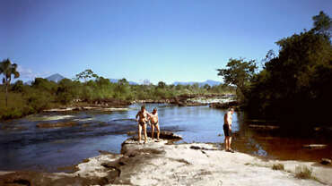
The Caribbean coastline north of Caracas is otherwise known as The Central Litoral. Encompassing the small towns of Maiquetia, La Guaira, Macuto and Caraballeda, the Litoral is a well-developed region inhabited by over half a million people. There are some sites of interest here, such as the colonial parts of La Guaira and the marina in Caraballeda. Some of the small towns – linked by a coast road – are holiday resorts and serve as a good alternative to Caracas, especially en route to or from the airport. The coastline is rocky, and not particularly suitable for swimming, but certain resorts have waters partitioned off for swimmers. These are known as balnearios. The Litoral is easily accessible by bus or taxi from the airport and from Caracas. The coast road reaches as far as Los Caracas, before becoming a dirt track which continues to a series of fishing villages and some beautiful sandy beaches backed by densely forested mountains. Accommodation is scarce here, but day-trips are possible from other towns.
Colonial Tovar
Colonial Tovar, founded by German settlers in 1843, was for years isolated from the outside world. Spanish only became the official language in the 1940s and a road link was not constructed until the 1960s. Set in the foothills of the coastal mountains, Colonial Tovar is famous for its weekend street markets. At an altitude of 1800m, the town enjoys a cool climate. It is easily reached from the coast, and has a variety of hotels and restaurants specializing in German cuisine. Hiking around the surrounding mountains is a popular activity, and the town has retained much of its original architecture.
Maracay
Maracay is the capital of Aragua state and has a population of 538,000. Founded in 1701, the city became an important agricultural center, yet did not expand until the arrival of Juan Vincente Gómez in the 1900s. The Gómez era saw the modernization of Maracay, with the construction of many new buildings, notably an opera house, mausoleum, and the largest Plaza Bolívar in the country. Maracay has continued to progress throughout the last century, and today the city is an important industrial, military and agricultural center. Little colonial architecture remains, but there are some sites and museums dotted around the place. Moreover, the city is the main entrance to the Henri Pittier National Park. Maracay maintains an average temperature of 25ºC and the rainy season lasts from April to October. It can be easily reached from Valencia and Caracas.
The Coast
Many beautiful beaches lie on the north coast. Just outside the Henri Pittier Park boundaries are the popular beaches of Cata, Cuyagua, Choroní and Puerto Colombia, all with dazzling white sands and a backdrop of lush vegetation. Accommodation and restaurants can be found in the area and boats are available for charter to the nearby beaches of Copo, Oricao and Aroa, all of which are inaccessible by land. In the state of Carabobo to the west lie the expansive white sands of Patanemo, complete with camping facilities.
Valencia
Founded in 1555, Valencia is the Capital of Carabobo state and the third largest city in Venezuela. The first three hundred years of its history were marked by successive bouts of bloodshed and violence. The city was pillaged and burnt down repeated times by pirates, Indians and adventurers, plagued by smallpox and devastated by the earthquake of 1812. The Wars of Independence followed, and Valencia was seized by the Royalist leader José Tomás Boves, who proceeded to plunder the city and massacre its people. Numerous battles were fought in the region, culminating with the Battle of Carabobo on the 24th June 1821, in which the victory of Bolívar’s army marked the end of three centuries of Spanish domination.
Today, Valencia is a significant agricultural and industrial center and has various historic monuments and parks. There are also several attractions around the city, including guided tours of the Campo Carabobo battlefields, the hot springs of Las Trincheras (the hottest of their kind in the world) an impressive collection of petroglyphs at Piedras Pintadas and the country’s only geoglyph: a gigantic rock carving in the mountain side at Hacienda Cariaprima. Valencia makes a good base from which to visit these sites, and plenty of accommodation is available. A bus terminal and national airport provide links to all major cities and towns.
Arístides Rojas Natural Monument
Located 5km northwest of the town of San Juán de los Morros sits the Arístides Rojas Natural Monument. This geological rarity is composed of morros, dramatic red sugar-loaf mountains created from coral reefs with the formation of the coastal mountains. The tallest morro stands at 1,060m. The monument has become a popular climbing spot and can be reached by road from San Juan de Los Morros and Caracas. The site is known as La Puerta de los Llanos (gateway to the Llanos) and provides an overland link with the giant plains.
National Parks of the Central Region
El Ávila National Park
El Ávila National Park covers 85,192ha of coastal and mountain habitat between Caracas and the Caribbean. Rising from the coast, the mountains reach 2,765m (Pico Naiaguatá) and 2,640m (Pico Silla de Caracas) at their highest points. While the southern slopes overlooking the city are largely uninhabited, the seaward slopes are scattered with settlements. The park is home to a diversity of fauna including jaguar, puma, ocelot, brocket deer, agouti, armadillo, opossum, red howler monkey, sloth and several species of snake. Birdlife is equally prolific and among the many species are toucans, parakeets, orioles, cuckoos, nighthawks and hummingbirds.
To enter the park, visitors require a permit (available from Inparques).The park has its own campsites and a hotel. Over 200km of hiking trails provide visitors with excellent routes to explore the park, weaving around beautiful waterfalls and up to panoramas with fantastic views. 4×4 vehicles can also be hired to access the single track which crosses the park. The park is accessible from Caracas or La Guaira.
Henri Pittier National Park
The Swiss biologist Henri Pittier was the first to point out the ecological problems in Venezuela and the necessity to protect the country’s ecosystems. Thanks to his pioneering efforts, the national park system was born and in 1937, the mountainous region along the northern coast became Venezuela’s first national park. Originally Rancho Grande, the park has been known as la Parque Nacional Henri Pittier since 1953. The park covers 107,800ha and extends south from the Caribbean coast into the mountains almost as far as Maracay. Its dramatic topography is characterized by steep slopes covered with deciduous and tropical forest and cloud forest at higher elevations.
The park’s flora is exuberant, and arboreal ferns, bromeliads, and several species of ornamental plant, notably the rare, endemic Gunnera pittierana, flourish. Animal life is equally diverse and the park is home to pumas, ocelots, otters, brocket deer, tapirs, kinkajous, coatis, tree porcupines, several species of snake and lizard and the marsupial frog. Moreover, because the park lies on a significant migratory route, the bird population is incredible. Some 550 species (over 40% of Venezuela’s birdlife) have been identified here, one of the highest recorded species densities in the world. The list includes curassows, parakeets, hawks, eagles, kites, toucans, oropendolas, parrotlets, owls, bellbirds, manakins, jays, caciques, chachalacas and woodpeckers. Portachelo Pass is the lowest point on the ridge, and as such is used as the crossing point by thousands of migratory birds each year, making it the best birdwatching spot in the entire park.
A biological research station (Estación Biologica de Rancho Grande) complete with a zoological museum is located within the park and is open to visitors. The park can be reached by bus or taxis from Maracay, and is a popular venue for hiking and camping. The rainy season is from April to November, and the dry season from December to March.
Macarao National Park
Macarao National Park lies within both the Federal District and the State of Miranda. Founded in 1973, the park, which protects the hydrographic resources of the capital, encompasses 15,000ha of coastal mountains. The boundaries include the basins of the Macarao and San Pedro Rivers. Sub-montane tropical moist forests and montane cloud forests are the primary vegetation types within which flourishes a variety of flora, notably orchids and tree ferns. Fauna includes red brocket deer, opossums, red howler monkeys, peccaries, raccoons, rabbits and three-toed sloth, tinamou, helmeted curassow, and band-tailed pigeons. Horseriding is popular in the park, which also has good hiking trails and picnic sites. The park is accessible from the road between Caracas and Los Teques.
San Esteban National Park
Located to the east of Henri Pittier, the San Esteban National Park covers 40,000ha. Founded in 1987, it encompasses the western tract of the coastal mountains as well as coastal habitats and the islands of Rey, Ratón, Alcatraz, Santo Domingo and Larga. The coastal region is characterized by dry forests, which give way to sub-montane tropical moist forests and montane cloud forests in the higher regions. Fauna includes puma, tapir, spectacled bear, deer, raccoon, ocelot; parrots, owls, doves, jays and many species of reptile. Swimming, diving and boat tours are popular, as are tours around the mountains of the park. San Esteban can be reached by road from Puerto Cabello.
Guatopo National Park
Southeast from Caracas and over the border into Miranda State is the Guatopo National Park. The park occupies the mountain range between the towns of Santa Teresa del Tuy and Altagracia de Orituco, covering an area of 92,640ha.
The park is predominantly covered by tropical moist forest streaked by numerous streams and rivers, and nurtures a rich and varied wildlife. Several species of orchid flourish amid the typical rainforest vegetation. Resident fauna includes jaguars, pumas, ocelots, margays, tapirs, giant armadillos, opossums, peccaries, capuchin and red howler monkeys, vipers, rattlesnakes, fer-de-lance, boas and coral snakes. A birdwatcher’s paradise, the park abounds with species such as harpy eagles, macaws, toucans, parrotlets, curassows, hawks, hummingbirds, chachalacas, caciques and green jays. The climate varies with altitude, and temperatures range from 14ºC to 32ºC. The park offers plenty of good hiking trails and camping facilities, and has a road link to Caracas serviced by regular buses.
The Northwest of Venezuela
Venezuela’s northwest comprises all the territory north and west of the Andes mountains. Four states comprise this large area of the country: Zulia, Falcon, Yaracuy and Lara.Zulia, Venezuela’s westernmost state, is known to be among the hottest places in Latin America and produces 70% of the country’s oil. It is also home to the famous Lake Maracaibo, which, covering an area of 12,800km², is the biggest lake on the continent.
Maracaibo
Maracaibo, the capital of the state, lies on the northwestern shore of the Lake. It was here that in 1499 the Spanish explorers Alonso de Ojeda and Amerigo Vespucci saw Indian houses perched on wooden stilts above the waters, and christened the land ‘Venezuela’ meaning ‘little Venice’. Maracaibo was settled in 1574, and formed successful trade routes with the Netherlands Antilles. On the 24th July 1823, the Republican Navy defeated the Spanish fleet on the waters of Lake Maracaibo, securing the liberation of Venezuela and all but ending the wars of Independence. Around 100 years later, oil was discovered in the region. Maracaibo, previously a quiet city, suddenly became the prosperous oil-capital of Venezuela.
Today, Maracaibo is a modern, bustling city with a skyline dominated by tower blocks and a population of 1.3 million. There is not a great deal for tourists here, though the town is dotted with colonial buildings and museums of some interest. Temperatures maintain an average of around 29°C, and most of the city closes in the heat of the day. Maracaibo has a large international airport with links to all major cities in the country and there is a bus link to and from Coro, Caracas, Valera, San Cristóbal and the Colombian town of Maicao.
However, various sites of interest can be found outside Maracaibo. The Rafael Urdaneta bridge, the longest pre-stressed concrete bridge in the world, stretches for 8,679m across the estuary of Lake Maracaibo and offers great views over the city. The colonial town of Altagracia lies on the other side of the lake, and can be reached by boat. The recently restored castle of San Carlos de Ibarra, built in the 1600s to ward off pirates, is now popular with tourists, as are the tours around the oil towers on the northeastern shores of the lake. The most popular tourist attraction, however, is the Sinamaica lagoon, the home of the Añu Indians. Here, you can see more or less what Alonso de Ojedo and Amerigo Vespucii would have seen when they sailed into the lake all those years ago.
Coro
Coro, capital of Falcón State, is a beautiful colonial city situated inland from the Paraguana Peninsula and has a population of 130,000. Coro is Arawak for wind, and the name refers to the constant breeze blowing through the city’s ancient streets. Founded in 1527, Coro was one of the first Spanish colonies in South America, and was the original capital of the Province of Venezuela. The Spanish settlers and Arawak Indians lived together in relative peace until the province was leased to the Germans, and thereafter exploited. The city of Coro deteriorated and, despite the annulment of German authority in 1546, continued to suffer throughout the 17th Century. The city was saved in the 18th Century, when the benefits of a booming smuggling trade with nearby islands were invested in its revival.
Today, Coro is a tranquil, cultural city. Some of Venezuela’s most impressive colonial architecture is found here, including one of the oldest cathedrals in the country and the age-old wooden cross in the Plaza de San Clemente. The colonial center of Coro is now preserved as a national monument. The city has an airport with regular connections to Caracas and Barquisimeto, and a port operating ferries to Aruba, Bonaire, Curaçao and other Caribbean islands. There are also bus links to major towns and cities. Coro makes a good base from which to visit the numerous national parks and natural attractions in the region. Various tours are available to the mountains and caves of the Sierra San Luis, the Península de Paraguaná and the desert of Los Médanos de Coro. Visitors can also hire cars and tour the sites independently.
Paraguaná Peninsula
Paraguaná is an island connected to the mainland by a narrow sandbank, and is the largest peninsula in the country. The landscape is predominantly semi-arid scrub and cactus, yet the region is also home to the small mountain of Cerro Santa Ana, whose slopes are thick with deciduous forest, cloud forest and grasses. The area has been declared a national monument, and is home to varied fauna including mountain cats, ocelots and numerous bird species. Beautiful panoramic views of the island are offered from the summit. Down below, village rooftops strongly contrast with the huge black oil refineries on the coast. In the distance lie solitary beaches, mangrove swamps, Caribbean islands and the pink waters of the salt mines. Punta Fijo is the biggest settlement on the peninsula, and has several hotels, a good road network and a bus terminal with links to many major towns and cities. There is an airport in nearby Las Piedras, with flights to Aruba and Curaçao, and to various cities within Venezuela. Organized tours around the Peninsula and to the Sierra San Luis are on offer in Punta Fijo, and hire cars, buses and taxis are available for independent exploration of the peninsula. The peninsula’s waters are also very popular with windsurfers.
Barquisimeto
The beautiful state of Lara is at the heart of Venezuela’s northwest. Here, lush valleys and rolling hills merge into mountains and mark the origin of the Andes. Much of the beautiful landscape is protected, and there are five national parks within the state. The state capital, Barquisimeto, has a population of 730,000, making it the fourth largest city in the country. Located in the foothills of the Andes, it is a dry hot city, with an average temperature of 25ºC. Barquisimeto is important both industrially and commercially, yet has had a troubled past. The town was founded in 1552, but was destroyed by fire shortly afterwards. It moved three times before its current location was permanently established in 1563. Development was slow, as the native Indians were hostile to the colonists and passionately defended their land. Little evidence of the era remains, as the earthquake of 1812 devastated all but a handful of the town’s colonial buildings.
Like many Venezuelan cities, Barquisimeto has been dramatically modernized in recent years. The city has several parks, museums, hotels and restaurants. There is an international airport with flights to America, Caracas, Margarita and various other destinations. The bus system is very good, and Barquisimeto is also accessible by the only passenger railway in the country, which operates from the coastal town of Puerto Cabello. Comparatively few tours to the surrounding region are on offer, but hire cars and a good bus network can be used to explore. Southwest of the city is the Quibor valley, where visitors can also buy traditional artesania such as rugs, hammocks, wooden carvings and pottery from indigenous communities.
San Felipe
Yaracuy is a small, little-known state sitting between the Andean foothills and the coast. The state capital is the pleasant town of San Felipe, which was founded in 1729 as San Felipe el Fuerte. At one point, the town was a significant commercial center, but was destroyed by the notorious earthquake of 1812. Today, remains of the old ruined town can be seen at Parque El Fuerte. However, sensational reporting has drawn more interest to the town of Chivacoa, whose mountains house the sacred site of the María Lionza cult. The cult – reputed to help people fulfill their desires – combines indigenous worship, African voodoo and Christian customs and involves witchcraft and magic. Belief in the cult has now spread throughout Venezuela, and people come to Chivacoa from far and wide to make offerings and worship the deity María Lionza.
The People
Zulia’s people, the Zulianos, are well known for their sense of humor and folk music. The state’s traditional music is the Gaita, and consists of improvised rhyming vocals over four-string guitars and maracas. The Gaita is featured in festivals throughout the year and has now become Venezuela’s traditional Christmas music.
In the northwest of Zulia live the Guajira Indians, the largest indigenous group in Venezuela. Living in a matriarchal society, the Guajira move with the limited water supply of the peninsula throughout the year. They are often seen in Maracaibo wearing their traditional dress; women in long, brightly colored dresses and men in loincloths. Many are artisans, and weave tapestries, blankets and hammocks to sell in the Guajira markets and craft shops.
National Parks of the Northwest
Morrocoy National Park National Parks
Morrocoy National Park is located on the east coast of the state, between the towns of Chichiriviche and Tucacas. Morrocoy became a national park in 1972, and comprises picturesque beaches, islands, keys, coral reefs, coconut groves and mangroves within its 32,090ha of coastal and marine habitats. For information on the islands of the park, click on the following link to Caribbean Islands. Adjacent to the park is the Cuare Wildlife Sanctuary, one of the world’s largest birdlife reserves. Together, they are home to nearly 80% of Venezuela’s aquatic birds and almost 70% of its migratory species. Herons, flamingos, scarlet ibis, boobies, pelicans, cormorants, egrets, hawks and hummingbirds are but a few. Moreover, the area is not just rich in birdlife. The lush hills behind the park are an important site for mammals, including jaguars, howler monkeys, anteaters, raccoons, opossums, kinkajous, agoutis, ocelots and mountain cats.
The park can be reached from Chichiriviche or Tucacas, which are both accessible by bus. Visitors can enjoy a variety of activities such as water skiing, snorkeling, scuba diving and sailing.
Médanos de Coro National Parks
Médanos de Coro is the only desert in Venezuela and was declared a national park in 1974. It lies on the Isthmus of Médanos and covers 91,280ha of desert and coastal habitat, including salt marshes. Massive sand dunes, known as Médanos can reach 40m in height and are constantly transformed by the unrelenting wind. Rainfall is rare, thus flora consists of little more than thorny shrubs. Likewise, fauna is scarce, and the park is home mainly to lizards, rabbits, anteaters, foxes, pigeons and kestrels. Visitors can wander amongst the dunes by camel, and the park is easily reached by bus or taxi from Coro.
Ciénaga De Los Olivitos Nature Reserve and Ciénagas del Catatumbo National Park National Parks
Eco-tourism around Lake Maracaibo is still in its infancy, though tours can be arranged to the Ciénagas del Catatumbo National Park and Ciénaga De Los Olivitos Nature Reserve, both of which are home to a variety of wildlife. Los Olivitos was established as a reserve in 1986, and rare species such as manatees, coastal alligators and sea turtles live within its 26,000ha of marine, coastal, freshwater and mangrove habitats. The reserve is also a significant site for migratory birds, notably flamingoes.
Ciénagas del Catatumbo National Park covers 269,400ha, and is situated on the southwest shore of the lake, between the rivers of Catatumbo and Santa Ana. It was granted national park status in 1991 to protect the rich swamp and wetland habitats of the area. The park has a large population of both resident and migratory birds, including species of heron, egret and stork. Mammals are also plentiful and include capybara, raccoon and freshwater dolphins. The area is known as the lighthouse of Maracaibo, as it is subject to regular lightening storms across its delta.
Perijá National Park
Perijá National Park lies south west of Lake Maracaibo and encompasses 295,288ha of the Serranía de Perijá, which runs along the Colombian border. The topography of the park is dramatic; the mountains rise abruptly from the lowlands of Lake Maracaibo to a height of 3,500m (Pico Tétari). The dense vegetation, comprising rainforest, cloud forests, highland moors and sub-alpine and alpine tundra is home to a wide variety of flora. The region’s rich fauna includes the spectacled bear and capuchin and howler monkeys. Access to the park is by road from Maracaibo, and organized tours are available. Camping is permitted in the grounds of the park.
Sierra de San Luis National Park
South of Coro are the mountains of the Sierra de San Luis, of which 20,000ha has been granted national park status. The entire sierra lies on a limestone base which has been eroded to form a network of caves and waterways, among which is the largest underground lake in the country: la Cueva del Río Acarite. The park harbors the hydrological resources of the Paraguaná Peninsula. Tropical and cloud forests cover the valleys and slopes, fostering a variety of flora and fauna including the oilbird (guácharo) and the mountain cat. The park can be reached from Curimagua, where there is also accommodation and tour agencies.
Cueva de la Quebrada del Toro National Park
Further to the southeast is the smaller park of Cueva de la Quebrada del Toro. The park is most famous for its extensive cave system and magnificent stalactites and stalagmites. The largest cavern, la Cueva del Toro is 1,200m long and is inhabited by the oilbird (guácharo) and many species of bats. Many of the caves have subterranean watercourses, including two vast reservoirs over 200m long which can be explored by boat. A guide is needed to enter the caves which can be reached by jeep from Santa Cruz de Bucaral.
Tirgua National Park
Situated in both Lara and Yaracuy states, Tirgua National Park encompasses part of the western mountain range known as the Cordillera de la Costa; actually a small branch of the Andes. The landscape consists of savanna and ridges carpeted in tropical dry and sub-montane forest. Several rivers flow through the park, all of which drain into the Orinoco basin. Wildlife includes howler and capuchin monkeys and an abundance of flora. The park can be reached by road from several towns in the surrounding area.
Terepaima National Park
Terepaima National Park is located south of Barquisimeto on the Rio Amarillo, actually within the state of Portuguesa. The park covers 16,971ha of savanna, rainforest, cloud forest and mountains, and is an important natural reservoir of hydraulic resources. Wildlife of the park includes puma, ocelot, opossum, capuchin and red howler monkey, kinkajou, skunk, tapir and sloth, and rattlesnakes. Birdlife is prolific, and species common to the park include racket-tails, wrens, finches, woodpeckers and mockingbirds. The park can be reached by road from Barquisimeto and has camping facilities.
El Guache National Park
Covering 125,000ha, El Guache spreads over the border into the state of Portuguesa and lies between two separate mountain ranges. The park’s vegetation is composed chiefly of sub-montane and montane flora, and resident fauna includes howler monkeys, spectacled bear, deer and anteaters.
Yacambú National Park
In the foothills of the Andes, the Yacambú National Park occupies some 14,580ha of tropical rainforest and the headwaters of the Rio Yacambú. The rugged topography and stunning landscapes of the eastern part of the park encompass the beautiful Laguna El Blanquito, the nearby Angostura Canyon dam and the dormant Sánáre volcano. An abundance of flora and fauna can be found in the park, including pumas, foxes, deer, opossums, a variety of birds, notably hummingbirds and parakeets, and many species of lizard and snake. The park can be reached from Quibor, Sanare, and Cubiro, and offers many tourist facilities, including camp sites, picnic areas and shops.
Cerro Saroche National Park
Cerro Saroche lies in the center of the state and covers 32,294ha of plains, hills and mountains. The land is covered mostly by dense lowland heath and resident fauna includes mountain cats, anteaters and turpials. Access to the park is from the town of Barquisimeto.
Yurubí National Park
North of San Felipe is the Yurubí National Park. The park is located in a mountainous region and covers an area of 23,670ha. The landscape is predominantly thick tropical vegetation streaked by the rivers of the Yurubí, Guayabito, and Carabobo. Rainforest gives way to cloud forest between 1,000-2,000m, and the moist air supports many arboreal ferns, orchids and bromeliads. Fauna includes ocelot, agouti, opossum, tapir and many species of reptile. The park is of great ecological importance as it protects the hydrographic basin of the Yacambú river, a vital source of water for San Felipe. Yurubí can be easily reached by road.
The Northeast of Venezuela
Venezuela’s northeast comprises the state of Sucre and parts of the states of Miranda, Anzoátegui and Monagas. When he first set eyes on the place, Christopher Columbus is said to have described it as a “Paradise on Earth”. Indeed, the region, with its clear blue waters, coral reefs, white sand beaches, mangroves and forested coastal mountains justifies such a description.
Puerto La Cruz
Puerto la Cruz is the younger and more boisterous neighbor of the Anzoátegui State capital, Barcelona. Originally a fishing village, Puerto la Cruz now has a population of 220,000 people and is the biggest tourist destination on the entire east coast. The town’s touristic center is concentrated around Paseo Colón, a seafront promenade brimming with hotels, restaurants, cafes, tour operators and marinas – tourists are certainly well catered for here. The city also has an efficient transport system. The port, La Guanta, runs several ferries each day to Margarita, and the bus terminal has connections to all major towns and cities. Barcelona has the nearest airport, which operates domestic flights to Caracas and major cities. A host of tours are on offer in Puerto la Cruz, and it is possible to arrange trips all over the northeast. Popular excursions include the islands of Morrocoy and Mochima, the beaches along the coast, the Orinoco Delta, Canaima, Caripe, the Guyana Highlands, the Angel Falls and Amazonas. Boats are also available for charter to the islands and beyond.
The beaches in Puerto la Cruz are not particularly popular, as the sea is polluted and unsuitable for swimming. However, a series of enchanting beaches are only a twenty minute bus ride away. Offering great views of the coast and islands, the road ascends east from Puerto la Cruz, over the border into Sucre State and into Mochima National Park.
Barlovento Bay
Barlovento Bay comprises the entire coast of Miranda State, from Higuerote to Boca de Uchire. The bay is named after the onshore trade winds that carry moist air to the coast, allowing its lush vegetation to flourish. The region was formerly known as the “Slave Coast”, as hundreds of African slaves were shipped in to work on its cacao plantations. Today, the African influence is clear in the region’s music, characterized by drums and dancing. Fine examples of colonial architecture can be found in the towns and villages dotted around Barlovento Bay. Many of the bay’s resorts – notably Boca de Uriche – are popular with Venezuelans, particularly Caraqueños, who motor down from the capital at weekends to enjoy the relaxing atmosphere and cool waters.
Higuerote
Higuerote, the first resort along Barlovento Bay, is a pleasant, relaxed town with a population of 14,000. A wealth of sandy beaches and clear waters lie along its coast, and tourism is on the increase. The town has numerous hotels and posadas as well as decent camping facilities, and can be reached by bus from Caracas.
Píritu and Puerto Píritu
Píritu and Puerto Píritu are twin towns situated just inside the neighboring state of Anzoátegui, and together house 19,000 people. They are pleasant, relaxing places and have a number of interesting colonial buildings as well as attractive sandy beaches. Plenty of hotels and restaurants are scattered around the towns, which can be reached by bus from Caracas and Puerto la Cruz. Nearby are the mangroves of Laguna de Píritu, popular with ornithologists, and the Islas de Piritu, well known for their sulphurous mud and excellent scuba diving. Tours to both can be arranged in town.
Cumanà
Further east lies the town of Cumaná, the capital of Sucre State and the oldest Spanish town in Latin America. Since the arrival of missioners in 1506, the town’s history has been marked by conflict with natives, pirates and traders. Little colonial architecture remains, as the city was largely destroyed by earthquakes and consequently rebuilt on three separate occasions.
Today, Cumaná plays a vital role in the country’s fishing industry and is a bustling tourist town with a quarter of a million inhabitants. Various sights are dotted around the town, and there are plenty of restaurants, hotels and tour operators. The town has air links to Caracas and Margarita, bus routes to Caracas, Puerto la Cruz, Caripe and Ciudad Bolívar and several daily ferry crossings to Margarita.
The Araya and Paría Peninsulas
North of Cumaná sits a large peninsula which has two arms: the arid landscapes and colorful salt lakes of Araya, and the rich bamboo forests and mangroves of its neighbor, Paría. Small fishing villages and towns are scattered along the coast. The two main tourist attractions, the salt mines and the Castillo de Santiago (Santiago Fort), can be found in the town of Araya, on the western tip of the peninsula. The fort was built in 1625 to defend the salt mines and was later abandoned after a hurricane caused the flooding of the salt mines in 1726. Today, the mines are back in operation and provide a large portion of the country’s salt. Both can be visited from Araya. The Peninsula also has many stunning white sand beaches and great windsurfing waters, especially around Araya, and there are good walks around the northern cliffs. A por puesto service covers the region, though travelling by jeep is the most practical way to explore due to the limited road network. Daily ferries operate to Cumaná. The Peninsula has a range of posadas and restaurants, and camping is popular.
Further east along the north coast lies the colonial town of Carúpano, home to some of the most beautiful beaches in the region: Pui Puy and Medina. Hidden in lush forest and fringed by palm trees, these paradise beaches offer accommodation and the latter has hot springs and waterfalls within walking distance. The town can be reached by bus from large cities in the region and the airport operates daily flights to Caracas and Isla Margarita. A ferry goes as far as the nearby village of Chacopata.
On the tip of the Paría Peninsula is its largest town, Güiria. Though the town itself has little by way of tourist attractions, the surrounding region has a much to offer. The surrounding mountains are part of the Península de Paría National Park, and can be explored right along the coast. Tours can also be arranged to the Orinoco Delta and Caribbean islands. The town can be reached by bus from most large cities, and the airport, just outside the town, operates flights to Margarita several times a week. There are regular ferry crossings to Margarita, Trinidad and other Caribbean islands.
Caripe
Inland to the south, the road winds into thickly-forested mountains, interspersed with shimmering lakes, picturesque mountain villages and coffee, pineapple and orange plantations. The road leads to the state capital, the oil city of Maturín, which is supposedly the fastest growing town in the world but is of little of interest to tourists. In the same region is Caripe, a tranquil tourist town in a beautiful mountain setting and a popular place for hiking, camping, cycling and horseriding. The town has plenty of posadas and hotels, and is easily reached by bus. The nearest airport is in Maturín. Several tour operators offer trips to the Orinoco Delta, the Gran Sabana and the nearby Cueva del Guácharo.
National Parks of the Northeast
Mochima National Park National Parks
Mochima National Park covers 94,900ha of coastal and marine habitat. For more information on the islands of the park, click on the following link to The Caribbean Islands. The mainland portion of the park consists principally of mountainous coastline, mangroves and golden sandy coves. Along the coast, scattered trees, grasses and shrubs predominate the dry terrain. As the land rises to the coastal mountains, the vegetation grows thicker and more exuberant, fostering a wider variety of flora, particularly ferns and orchids. Resident fauna includes jaguars, sloths, capuchin monkeys, opossums, armadillos, agoutis, iguanas, many species of snake and sea-birds such as gulls, pelicans and frigates.
Playa Arapito, Playa Colorada and Playa Santa Fe are the best known of Mochima’s beaches. Though quiet throughout the week, the beaches transform into busy tourist hotspots at weekends. The calm waters are perfect for swimming and fishing boats can be chartered to visit a number of islands and reefs just offshore, which are wonderful for snorkeling and fishing. Further inland are waterfalls, clear pools and woodland hiking trails. All the villages have several small hotels, posadas, and restaurants, and camping is popular on the beaches. Por puestos, taxis and buses operate along the coast road and any beach or bay is easily accessible.
Rio Chico and Laguna de Tacarigua National park
Along the coast of Barlovento Bay is Rio Chico, a town roughly equal in size to Higuerote. The beaches are attractive and the town is a popular destination with Venezuelans. Buses also operate to Rio Chico from Caracas, and there are various hotels. Situated behind the town is the Tacarigua de la Laguna National park. The park consists of a coastal lagoon separated from the sea by a sand bank, and comprises 18,400ha of important wetland habitats. The region is home to a rich aquatic bird fauna, including pelicans, cormorants, flamingoes, frigates, egrets and ibis. Visitors can enjoy tours around the lagoon and the maze of surrounding canals, and boats can be hired to explore the park and surrounding beaches. Permits (available from Inparques) are needed to enter the park. Access is from the village of Tacarigua.
Península de Paría National Park
Occupying some 37,500ha, the Península de Paría National Park encompasses the single mountain range on the northeast tip of the peninsula. The relief is relatively low; coastal lowlands rise into steep slopes reaching a height of 1,300m. The arid coastline is rich in xerophytes while thick deciduous, tropical moist and cloud forests cover the mountain sides, fostering a diversity of bromeliads, heliconias, lianas, orchids and an abundance of climbers and endemic epiphytes. The endemic colored parakeet inhabits the park, and mammal species include puma, ocelot, deer, armadillo and monkey. Access to the park is via the road between Carúpano and Güiria or by boat. Tours are available.
Turuépano National Park
Turuépano National Park encompasses Turuépano Island in the Gulf of Paría, south of the Peninsula. Covering some 70,000ha, it is the most extensive area of protected marshlands in Venezuela. Savannas, lagoons, channels, marshes, mangroves, swamp forests and peat bogs form an incredibly biodiverse landscape. The most prolific flora are ferns and moriche palms. The wide range of wetland habitats supports a variety of fauna including otters, tapir, fox, raccoon, bats, many species of waterfowl, water-snakes, coastal alligators and cayman. The park is also inhabited by the Warao Indians. The entrance to the park is from Puerto Ajíes and can only be reached by boat.
Cueva del Guácharo National Park
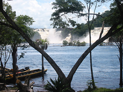
The Cueva del Guácharo National Park covers an area of 45,500ha. The main feature of the park is the cave system itself, which, with a length of over 10.5 km, is the largest in the country. It was discovered along with its unique inhabitant, the guácharo (oilbird) by the scientist and explorer Alexander Humboldt in 1799. A unique, frugiverous (fruit-eating) species, the oilbird leaves the cave at dusk to search for food, using echolocation to maneuver in the dark. The colony numbers around 18,000 and occupies the first chamber of the cave together with mice, crickets and crabs. Visitors are guided by lanterns down a concrete path that meanders alongside a stream and amongst vast piles of decomposing palm-seeds dropped by the guácharos. Spindly palm-seedlings sprout from these mounds, but soon die, starved of light. Ornate stalactites and stalagmites and other intriguing geological formations decorate the entire subterranean network, many of which resemble and are named after plants, animals and famous landmarks. Visitors have access to the first sector of the cave; deeper exploration is possible but only with specialized equipment and permission from the park’s authorities. Access varies according to the time of year, as the caves are liable to flood during the rainy season in August and September.
The remainder of the park, accessible by trails, encompasses thick, lush forest and a waterfall and is home to a variety of birds and plants.
The Caribean Islands from Venezuela
72 Caribbean islands lie off Venezuela’s 2,800km of coastline. Of these, Isla Margarita is the largest and most populated. (Click on the link for a detailed description). The remaining islands comprise the archipelagos of Los Roques and Las Aves, the national parks of Morrocoy and Mochima and the large islands of La Tortuga, Los Testigos, La Blanquilla, La Orchila and Aves.
The Archipelago Los Roques
The archipelago of Los Roques is probably the best known of Venezuela’s Caribbean islands. Situated 170km north of Caracas, it is an atoll of reef-islands, tidal islets and reefs surrounding the Laguna Central, and is one of Venezuela’s most beautiful sights. A massive variety of marine life exists in and around the reef habitats, and for this, the area was declared a national park in 1972. Covering an area of over 225,153ha, the archipelago is Venezuela’s largest marine park. The islands are edged with brilliant white sand, and at low tide, finger-like sandbars protrude into the turquoise sea. The waters over the surrounding 19km of coral garden are crystal clear, providing fantastic snorkeling and scuba diving opportunities. The coastlines, interspersed with green mangroves, form a striking contrast with the barren grass and arid scrub of the inland terrain.
The archipelago maintains an average annual temperature of 29ºC, though nights remain cool thanks to the regional breeze. The temperature reaches a peak of 34ºC in July and a low of 24ºC in January, and there is occasional rain from September to January.
Los Roques was originally settled by Indians some 900 years ago. Colonization began some years later on Isla El Gran Roque, after Margariteño fishermen discovered the rich waters of the area. Today, El Gran Roque, the largest of the islands, is home to the majority of the archipelago’s 1,000 or so inhabitants. The remainder of the population is mostly Caraqueños, who reside in holiday homes on the neighboring islands of Rasquí and Madrizquí. Many tourists also frequent the archipelago, and the most visited island is Cayo Francés. Like Isla Margarita, Cayo Francés is comprised of two islands connected by a sandbank, and provides both calm waters and surf.
Los Roques is renowned for its variety of marine fauna. Just some of the many species include parrotfish, barracuda, red snapper, dolphin, shark, octopus, lobster and the near-extinct queen conch. Green turtles visit the beaches to lay their eggs, and the island of Dos Mosquises Sur is the home of La Fundación Científica Los Roques, a biological research station dedicated to preserving the green turtle populations in the region. The resident and migrant bird population of the archipelago exceeds 90 species and includes enormous gull colonies, boobies, frigates, pelicans, herons and scarlet ibis. No native mammals inhabit the area, but dogs and goats have been introduced on El Gran Roque. Many reptiles, including iguanas, chameleons and salamanders, live on the larger islands.
Tourists visiting the Los Roques can explore the region by taking day-trips or by chartering a boat. There are 30 or so hotels on El Gran Roque, and posadas on Cayo Francés, Francisqui and Krasqui. Those wishing to camp need to obtain a permit from Inparques in Caracas. Daily flights operate to Los Roques from Margarita and Maiquetia. The archipelago can also be reached by boat from La Guaira, a town northeast of Caracas. Some tour operators offer all-inclusive package deals to the islands.
The Archipelago Las Aves
Archipelago Las Aves is Los Roques lesser-known western neighbor. It shares the same crystal clear waters and abundant marine life, but is a lot quieter. Fishing, snorkeling and scuba diving are excellent. Las Aves can be reached by boat charter from Los Roques, but is more commonly visited by yachts sailing between Bonaire and the mainland.
The Archipelago Los Testigos
Northeast of Margarita is Los Testigos, a small archipelago of three islands: Isla Conejo, Isla Iguana and the larger Isla Testigo Grande. Home to a huge colony of frigate birds and a small population of fishermen, the area is renowned for good lobster and fresh fish. It is, however, a protected area, and diving and the use of harpoons are not permitted. Los Testigos can be reached by boat charter only.
Isla La Tortuga
Isla La Tortuga is Venezuela’s second-largest island and lies west of Margarita. Its landscape is rather flat and arid, but bordered by stunning sandy beaches and clear blue waters. The island offers great opportunities for fishing, diving and snorkeling, particularly around the offshore coral reefs of Los Palaquemos, which are easily accessible by boat. Yachts and charters frequently anchor around la Tortuga, and are the most common way of reaching the island. The island has an airstrip for light aircraft.
Isla Blanquilla and Isla La Orchilla
Isla Blanquilla, lying north of Margarita, is reputed to have the best snorkeling and diving in the whole of Venezuela. The coast is lined with dazzling white sandy beaches and coves, and numerous caves – both underwater and on the shore – await exploration. The island is accessible by boat or plane, and various tours, including day-trips are available from Margarita. Not far from Blanquilla is Isla La Orchilla. Like its neighbor, Orchilla is surrounded by amazing coral reefs good for snorkeling, and can be reached by boat from Los Roques.
Isla de Aves
Located 500 km north of Margarita, Isla de Aves is Venezuela’s most distant Caribbean island. The island has an area of 65km², yet coastguards are its only inhabitants. As its name suggests, Isla de Aves is home to massive sea bird colonies, and is also an important nesting site for the rare and endangered green turtle. The clear waters of the island can be reached by yachts and boat charter from Bonaire and the mainland.
National Parks of the Caribe
Morrocoy National Park National Parks
Morrocoy National Park is another beautiful region of the Caribbean. Situated on the east coast of the Falcón State, the park comprises 32,090ha of coral islands and reefs, as well as part of the mainland coast. For more information on the mainland area of the park, click on the following link to The Northwest. The park was founded in 1974, and its calm blue waters, numerous coral gardens and deserted beaches attract a great number of Venezuelan and foreign tourists alike. The park is renowned for its birdlife, which includes frigates, pelicans, cormorants and boobies. Oyster beds line the mangroves, and marine life is prolific. Hundreds of colorful fish live in and around the reefs, and stingray bask in the shallows. There are excellent spots for snorkeling and diving, and water skiing is becoming increasingly popular. The most-visited island is Cayo Sombrero, which can get busy at weekends and during national holidays.
To explore the park, tourists can charter boats or go on day-trips from the mainland towns of Tucacas and Chichiriviche. At low tide, it is possible to go between some islands on foot. The only way to stay on the islands is to camp, though there is no fresh water.