Regions in Kazakhstan
Akmola region
The region occupies territory extremely favorable for development of tourist business.
Great possibilities have many areas of the region for internal tourism development. There is a developed network of rest houses, sanatoria, tourist bases, dispensaries, boarding houses etc.
Shchuchinsk-Burabai resort zone is the resort place with fine natural-climatic conditions rich with medical-recreational resources and historical and cultural fund, favorable geographical arrangement in the centre of Republic, affinity to Astana, the capital of RK. In the future it promises to become the great modern tourist centre of Eurasia. Here it is planned to construct objects of business, welfare, scientifically-educational, and also entertaining appointment.
The big attention is given to infrastructure development for attraction foreign capital on the further development of resort zone. Actions have been worked out for building new roads, opening aircraft service, providing stable water-and power supply. The given measures will provide creation of conditions for investments into building edifices and constructions for residing, productive leisure and tourists’ communication.
Special economic zone «Burabai» is created to develop its territory into tourist entertaining centre for the purpose of creation favorable investment climate and attraction for domestic and foreign investments.
The tourist entertaining centre is social project: to transfer of gambling institutions will allow to reanimate an investment climate of this area, to create additional workplaces, to increase tax revenues, and also to promote development of an accompanying infrastructure.
Development of Shchuchinsk-Burabai resort zone will be promoted by the fact, than the arrangement of one of two especially taken away centres is defined at this place, where the gaming will develop.
As a whole, the area possesses huge potential for attraction investments into economy development of the region, including the international tourist business and is ready to consider any offers on cooperation.
Almaty region
The Almaty region was formed on March 10, 1932, its area is 224 thousand square kilometers.The region is located in the far southeast of the Republic, in the east it borders on China, in the south on Kyrgyzstan.
The administrative center is the town of Taldykorgan located in the southeast of the country at the foot of the Zhungar Alatau northern slopes at an altitude of 570-630 m above sea level on the Karatal river bank. At present there are 133,4 thousand inhabitants of seventy nationalities. Taldykorgan is one of the very green towns in the Republic, it is buried in verdure of parks and gardens. There are many relics of the v pasti which are a part of historical and cultural heritage.
There is beautiful and wonderful land in the Almaty region with century-old history called “Zhetysu”, it means seven rivers which run here and fall into the Balkhash Lake.
Ancient culture of the Kazakh people is reflected in invaluable monuments of the past, stone sculptures and burial mounds are among them, ruins of sites of ancient -cities also remind us about great history of this land inhabited by man from time immemorial. In the Middle Ages Semirechie was a very important agricultural and trade center, one of The Great Silk Road routes ran across its territory.
The Almaty region has the great tourist recreational potential giving an opportunity for development of tourism both domestic and international. The region also has considerable resources for mountain tourism and rock climbing development.
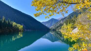
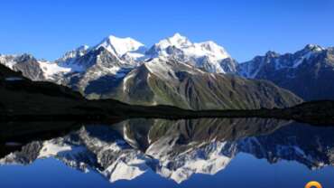
The Zaili and Zhungar Alatau mountain ranges are unique. The Kan-Tengri peak (7014 m), located in Central Tien Shan, is the highest top in the country. The mountains abound in picturesque lakes and waterfalls.
The tourist routes lead to unique natural historical-cultural, archaeological places of interest such as the Charyn river, Kolsai lakes, relic Ash-tree grove, “Singing Barkhan”, “Burkhan Bulak” waterfall, Anrakai Battle place, Zhambyl’s Museum, Zharkent Mosque, small town of handicraftsmen “Sheber Aul”.
The rivers Charyn, Koksu, Karatal, Hi are attractive for sport-recreation rafting, the lakes Alakol, Balkhash and Kapshagai water body are favourite places for nature lovers who are fond of water tourism ranging from fishing to sailing.
There are unrivaled places of untouched nature where hunting and fishing develop. It is a real treasure for those who are fond of these kinds of sport. Vast tracts and unspoilt beauties of nature will be evaluated even by very experienced tourists.
Zhetysu land with its climatic conditions and magnificent landscape is very interesting and attractive for those who like to travel and to acquire knowledge of the world.
Nature and environment conditions
Environment of Almaty region includes 5 climatic zones – from deserts to eternal snow. A climate sharply continental, average temperature of January in a flat part-15 With, in foothills – 6-8 With; July – +16 With and +24+25 With accordingly. An annual amount of precipitation on plains – to 300 mm, in foothills and mountains – from 500-700 to 1000 mm a year.
Flora and region fauna
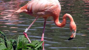
Nature of the region is special. Within one day it is possible to cross actually all geographical zones – from desert to eternal snow. Various plants, grasses, trees grow in foothills and slopes of mountains, hundreds kinds of wild animals, including a rare snow leopard live. In the bottom belt of mountains (to 600 metres) travellers will meet green deciduous woods, having risen above, can take pleasure in a steppe landscape, in valleys of the rivers – fruit gardens, aspen wood, hawthorn thickets. The fauna of these edges also is various. Here probably to meet hares, fiber, hamsters, badgers and even brown bears. At tops of mountains mountain goats, архары, grey steppe fibers live. Many birds live in woods: свиристель, an owl, mountain daws, partridges and pheasants. It is good to visit Pribalhashe in the middle of May. At this time poppies here blossom, and all steppe is very picturesquely covered by “a red flower carpet».
Aktobe
It is known that since those ancient times when heavenly Turkis confirming that they descend from the holy mythic Otiken from Altai, were the first in the history of the humanity to saddle horse, to invent a wheel and to place a nomad tent on the bullock-cart, they had often risen together and roamed from place to place to the west in search of the new lands and homes. And the humanity remembers the Great Resettlement of Nations. And the centuries-old Great Resettlement could not go round this land. The nomads who did not pass through Aktobe land would have bumped into thick Siberian forests or the Khazar Sea (the Caspian Sea).
The population of Aktobe region is 713.9 people. It boarders Kostanai and Karaganda regions in the south-eats, Kyzylorda and Mangistau regions in the south-west, Atyrau and West-Kazakhstan regions in the north-west and Russia in the north. So it is the region which has a great geopoliteical, economic and strategic significance in the western part of Kazakhstan.
bowels of the region are very rich, its economic potential is very big.
The struggle against the Djungars’ invasion and the invasion of Russian empire was continually carried on this land. The nation fighting for its freedom stood a lot of ordeals, shed a great deal of blood. And later the people suffered much trouble due to other disagreements in the Russian society which fell into “the white” and “the red”, suffered hard pangs of the revolution, collectivization, compulsion to settled life, artificially organized famine.
Aktobe land possesses big economic potential, very rich bowels and rather high intellectual and cultural level. Competent use of these opportunities in compliance with the spirit of the time provides the ground for rapid development and continuous growth of economy. The bowels of Aktobe land contain 10 per cent of the explored reserves of the country’s oil, 30 per cent of the forecasted hydrocarbon raw materials, 100 per cent of Kazakhstan! chromium are also found here. The region takes the second place in the world in the chrome ore reserves (over 400 mln tons), the third place in the Republic in ore (1 00 mln tons), the fourth place in gas reserves.
55 per cent of nickel, 40 per cent of titanium, 34 per cent of phosphorites, 4.7 per cent of zinc, 3.6 per cent of copper, 2 per cent of aluminum, 1.4 per cent of coal of the country are found in the bowels of Aktobe land. There is gold, silver, cobalt, potash salts, asbestos, kaolin, glass and colour stony raw materials, natural decoration materials, oil and bitumen deposits, mineral waters, raw materials necessary for construction and other natural resources. There are good opportunities to develop agriculture in the region. Northern regions situated on fertile soils are engaged in grain production and breeding pedigree live-stock, and regions situated in the semi-desert zone mainly breed cattle.
The nature of the region situated on the vast territory is brought about by the phenomena inherent to the steppe. The primordial ancient mountains Mugodzhars are the spurs of the Urals which spread into the steppe. The major water resources are the rivers Orr, llek, Khobda, Uil, Irgiz, Zhem, Sagis and small rivers and also steppe lakes, the largest of which are situated in the Irgiz region. The balance of the dry continental climate of the region depends on these natural reservoirs. The pride of the region is Torgai national park created on the territory of Irgiz region in 1967. On this territory there are big lakes and rivers (Torgai, Olkeiyek, Telgara, Irgiz), 29 species of animals and 170 species of birds, 30 of which are entered into the Red Book, are found here. In Kargala, Khobda regions there are elks, on Baiganin and Uil lands you can find wild goats, in Irgiz and Shalkar regions saigas and wild boars.
Branches of education, health care, culture, sport, transport of this rich and spacious region are developing very fast and improving every year. Such major institutions of higher education as Military Institute of Air Forces after T. Bigeldinov, Western Kazakhstan Medical Academy after M. Ospanov, Aktobe StateK. Zhubanov University, Aktobe State Teachers’ Training Institute, institutes and branches of Transport and Communication Academy after M. Tynyshbayev, Kazakh State Law Academy, Academy of Economics and Statistics, Central-Asian University, University after S. Baishev, 21 colleges and 16 professional lyceums, training in different specialities, 474 schools of general education, 99 pre-school institutions, 5 specialized schools.
Social conditions of the life of the population of the region are improving rapidly. For the past two years the number of new schools, hospitals, cultural centers, large trade centers and houses has increased twofold. The construction of new houses has greatly increased and the region has become one of the best in the republic.
The reason of such rapid development is the growth of economy due to the competent management in compliance with the requirements of the time, duly and qualitative realization of the tasks set by the President, reflection of energy and efforts of the region’s population confident in their future.
The impetuous development of Aktobe land can be clearly seen by several indexes of the results of 2007.
– For the first time in the history of the region the total volume of production exceeded 500 bin in 2006 and reached 620.0 bin tenge in 2007. It is by 103.3 bin tenge higher than in 2006.
-By the growth of the processing industry our region has become one of the three best regions of the country!
-71 project valued at 308.6 bin tenge have been realized, 52 of which being industrial enterprises.
-Koktau mining concentration industrial complex, capable of producing 200 thousand tons of copper concentrate per year has been put into operation. It took a little over a year to build this complex in the bare steppe. Its second production line will be put into operation in 2008 and will be able to produce 47 thousand tons of zinc concentrate per year, and production of copper will achieve 260 thousand tons. The construction of the metallurgic plant has been planned.
All that has become possible due to the realization of the measures of the Strategy of industrial and innovation development, creation of high technology aimed at the production of the goods with high added value.
– To support agriculture 3.7 bin tenge have been allotted;
– During the year 4078 families became owners of the new houses;
– 420.2 thousand of square meters of housing have been put into exploitation in total;
– 20.3 bin tenge were allocated to the education sphere; 11.3 bin to the health care system;
– 1567.9 bin tenge were allotted to the sphere of culture.
Large, middle-sized business, investors and entrepreneurs make an immense contribution into the development of economy. 94 per cent of the region production is manufactured at the region industrial enterprises: JSC CNPC “Aktobemunaigas”, Donskoi mining concentration industrial complex, referring to “Kazchrom” transnational corporation, Aktobe Ferro Alloy Plant, JSc “Aktobe Chrome Compounds Plant”, JSC “Avia-Repair Plant of Civil Aviation-406”, JSC “Aktubrentgen”.PLC “Aktube-Kurylys”, “Omirbek”, KCDK “Great Wall”, “Koktas Aktobe”, “Voschod-Oriel”, “Zhorga-RD”, “ZhAK” are among major Aktobe enterprises. They do not only produce their own goods but are also engaged in social, cultural and spiritual spheres.
Air, railway and automobile transport communications of the region have been successfully developing lately. Aktobe airport has been built up to the world standards. Now passenger and cargo terminals are being reconstructed. Regional parts of railway and automobile roads connecting Aktobe and Astana have been put into operation, roads Shymkent-Samara, Aktobe-Uralsk, Aktobe-Atyrau and other internal roads are being built and repaired.
Aktobe oblast has prepared over 120 investment projects valued at 8 bin US dollars under the aegis of industrial and innovation strategy. Six of them are included into the state programme “30 corporate leaders of Kazakhstan”, projects of the construction of Zhanazhol gas processing plant with the capacity of 6 bin cubic meters of gas per year, electric metallurgical plant in Aktobe, copper-smelting and mining concentration industrial complex, glass producing plant with the capacity of 21.7 mln square meters of glass per year, chrome ore concentration industrial complex, plant producing 1200 railway carriages per year are among them. Their total cost is 3 bin dollars.
The present day Aktobe region is a flourishing land developing very fast. The social, cultural and spiritual level of its population is continually growing. The people are confident that their future will be still better than the present. It is guaranteed by the economy acquiring more and more power, the population possessing good knowledge, cultural and intellectual potential, showing social activity and unanimity, and also wise and far-sighted policy of the President of our country Nursultan Abishevich Nazarbayev. Competent activity and energy of leaders of the regional and local authorities can be added to these factors.
In a word, Aktobe land is the place one can be proud of. It is the home of hospitable, wistful, strong people.
Atyrau region
In 50 km from the modern city of Atyrau, there is one of perspective tourist routes, regional memorial estate “Khan Ordaly Sarajshyk” who opens all ancient history of the Kazakh people. With the snow-white beauty and greatness of fine creation of human hands amazes this memorial complex of seven khans.
Site of ancient settlement of Sarajdzhuk (the present name – the Shed) along with other cities, has been erected in the first decades of a life of empire – улуса by Zhoshy who then was called as Golden Horde, for management of huge territory from Irtysh to Danube. At first these cities served as points in which palaces and office buildings for the nobility – нукеров were erected, найонов and others operating territory subject by it. Round the central buildings dwellings various люда – handicraftsmen subsequently grew, free inhabitants, merchants and т.д Sarajdzhuk was one of such cities. Constructed on central in the strategic relation a site of a joint of Europe and Asia, it provided safety of a piece of a transcontinental caravan track from the countries of Europe and capital of Golden Horde (the Shed – to Bath and the Shed – Berk) on Volga in cities of Khoresm, Iran, India and China.
The trading road from the Shed to Sarajdzhuka and to Urgench has been supplied further by wells and caravans-sheds. It was the basic way connecting the East and the West. The important geopolitical point on the Great Silk way.
Owing to it in Sarajdzhuke magnificent palaces, a caravan a shed, baths, mosques, медресе and other magnificent buildings were under construction. They were erected by talented masters from the most known architectural schools. The city had well developed lay-out with direct wide streets and the areas.
During stationary researches West Kazakhstan expeditions of Institute of archeology of A.H.Margulana the considerable area of a site of ancient settlement on its different sites, concerning the first period has been opened.
Finds in Shed ruins – глазурные the Iranian pottery and the Khorezm ware from grey clay, the Chinese porcelain products, bone pipes, mattocks, legs, fishing tackles for fishing, nails – confirm that townspeople were engaged in trade, craft, melon growing and truck farming. Here jeweller ornaments typical only for this edge, jugs from the burnt clay with patterns, wax candles, ceramic tableware, water pipes, etc. household goods are found.
Comprehension of the historical importance of Sarajdzhuka, its special role in an initial stage of formation of the Kazakh statehood and exclusive importance of a cultural heritage of ancestors for spiritual communication of generations has led to creation of the muzejno-memorial complex consisting of a symbolical pantheon, an archeology and mosque museum.
Now the memorial complex «the Khan-Ordaly the Shed» causes the big interest from outside visitors, tourists, various delegations both near, and the far abroad.
East-Kazakhstan region
This region can be considered as a united tourist destination. Most important is to consider it in the same way as it would be viewed by a potential customer, e.g. foreign tourist.
Firstly, Eastern Kazakhstan is situated in the center of the Eurasian continent, which is marked by a corresponding memorial, at the crossing point of the 79th parallel and 49th meridian. Additionally, East Kazakhstan has a unique geopolitical position.
The region is located in the spot where four large states connect: Mongolia, Kazakhstan, China and Russia.
Due to these two facts, East Kazakhstan’s uniqueness factor is very high. It is a resource which could be used to create effective advertising.
An interesting peculiarity of East Kazakhstan is the possibility to observe on its territory nearly all varieties of Central Asian landscape in a relatively small area. Its territory can be traversed in one tour. Here one has the opportunity to see:
# Sandy desert landscapes
# Clay canyons
# Classical steppes
# Mountain steppe landscapes
# Deciduous forests and taiga
# Alpine meadows and mountain peaks, whose heights reach 4500 meters above sea level (such as the highest point in the Altai and Siberia – Belukha Mountain).
This unique geographical and geopolitical position, in addition to landscape diversity, caused a mixing of cultures and traditions. During one tour one has the possibility to meet with traditional nomadic Kazakhs, representatives of the Kazakh fishing subculture, and Old Believers and to visit a maral nursery (a traditional occupation of old believers). All this in total provides an interesting, varied and dynamic trip schedule for tourists.
The rich bio-diversity is maintained by 24 nature reserves, whose area amounts to 6% of the total of East Kazakhstan. Rare and endemic animals, which can be viewed here, attract nature lovers: birdwatchers and butterfly watchers. The nominal border between Asian and Siberian fauna lies across the territory of East Kazakhstan.
Special attention should be paid to the territory of the Kazakhstan Altai, which is part of the Altai-Sayan eco-region. By its landscape distinctiveness and biological diversity it is one of 200 priority global eco-regions, defined by the International organization, WWF Living Planet.
To the present day this territory has avoided destructive urbanization.
Thus, the East Kazakhstan region is a region where tourist sites of global uniqueness are available. Its landscape diversity and cultural mix is an effective confirmation of the tourist potential of the region.
Karaganda region
Karaganda region is region in the central part of Kazakhstan, located in the heart of Eurasia, almost equidistant from the Arctic and the Indian, the Atlantic and the Pacific Ocean. Territory of the region is 428 km ². In the region live tenth of the total population of Kazakhstan. Population of region are 1 351 854 people and representatives of over 113 nationalities.
Karaganda region was formed in March 1932. Initially, the regional center was the city Petropavlovsk. On 3 August, 1936 Regional Center is located in Karaganda.
In its present borders, the region was formed in May 1997 it was annexed to the Zhezkazgan region.
Currently, Karaganda region – is the largest area of territory and industrial potential, rich in minerals and raw materials. This is a powerful industrial center. According to economic, cultural and scientific potential, infrastructure area occupies a leading position in Kazakhstan.
Railway connects the region with the cities of CIS countries, Germany and China. International Airport “Sary-Arka” carries out direct flights to Russia, Germany, United Arab Emirates and other countries. Through the Karaganda region passed automobile road which connect Almaty and the capital of Kazakhstan Astana.
Freely and widely spread over the Karaganda region in the vast steppes of Sary-Arka. The region’s territory is the most elevated central part of Kazakhstan hills. From Karkaralinsk mountains in the east to the west of Lake Tengiz, from Ishim in the north to Sherubai-Nura reservoir in the south stretches the wide steppe, where the Kazakh people since ancient times awarded the poetic name of Sary-Arka, which means “yellow mountain range”.
The climate of the area is continental: summer is hot and dry, winter with snowless, but the harsh winds and snowstorms. On summer days temperature can reach 37 degrees. The coldest month is January. Frosts reach up to 40 degrees.
In the area there are more than two hundred large and small rivers. Home artery area – Nura River crosses the province from east to west and empties into one of the largest lakes in Central Kazakhstan is Tengiz. In the south of region situated is the largest lake in Kazakhstan – Balkhash. Its uniqueness lies in the fact that in the eastern part of the water is salty, in the west part is fresh.
The Karaganda region is known in history primarily to the fact that its territory is the northern branch of the ancient Silk Road. Historically, this region was trading artery, a channel for economic and cultural exchange between Kazakhstan and other countries.
In the 30’s and 40’s of the XX century the region was the site of Stalin’s deportation of repressed peoples. Here was stationed notorious Karlag. After II World War stationed in Spassk camp for Germanic, Japanese, Italian and Romanian prisoners of war, which is currently open Memorial to Victims of Stalinist totalitarianism. According to historians, there are 5152 graves of prisoners of war of various nationalities.
Wildlife area is very diverse. In the south and south-west spread over pastures that attract herds of saiga. Also in the field has spread wolves, foxes, gazelles, argali, hares, badgers, wild boars, weasels, ferrets. In pine forests can meet protein.
In lakes and rivers are home to carp, perch, Marina, pike, chebak etc.
Saryarka always ready to truly Kazakh hospitality to tourists from near and far abroad.
Kyzylorda region
Kyzylorda region is situated in the zone of sharp-continental climate. The number of sunny days in the year is more than 300.
The most favorable time to visit the area – September. Summer heat subsides and the autumn cold had not yet come.
The landscape of Kyzylorda region is diverse and offers unforgettable experience, the main one is Syrdaria – wild, giving birth to all living in this region river.
In the south there is a mountain range of Karatau. There are springs with the crystal clear water and amazing taste in the small valleys. The green carpet of grass invites you to relax after a long and hard journey.
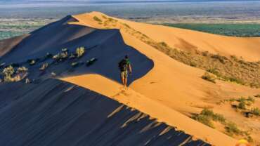
South-east region breathes with heat from Kyzylkum desert. Searing heat, singing dunes, quicksands, a monotonous landscape of the desert are fascinating and stay in your memory for a lifetime. In the north – the Aral Sea with its turquoise water and sandy beaches. The reeds of National Nature Reserve Barsa – Kelmes conceal from view nesting of birds and herds of rare species of the steppe animals. From time to time the waves of the sea slightly open secret history of the Middle Ages, introducing gaze ruins of ancient buildings.
Here you can see the fishing of flounder, small fishing boats and try the dishes of freshly caught fish.
The unique attraction of the landscape of Kyzylorda region – is steppe – space, striated with thousands of threads of ancient caravan trails, where the view dissolves into the horizon from east to west and from north to south.
Population of Kyzylorda region belongs to various ethnic groups. The overwhelming majority – Kazakhs, then Koreans, Russian, Tatars, Ukrainians, Jews, representatives of the Caucasian peoples: Chechens, Ingush, Armenians. The urban population is more than rural. Farmers are busy, mainly with livestock, growing of rice, fruits and vegetables. It is in the countryside preserved many folk customs, traditions and ceremonies.
Syrdarya – the ancient cradle of the modern inhabitants of Kyzylorda region and till this day they say about it with reverence: Syr eli, Motherland.
There are many monuments preserved, most of whom were bright jewels on the thread of the Great Silk Road. Ruins of cities such as Jend, Sauran, Yangikent amaze the imagination even nowadays.
Jend: in the tenth century the city belonged to the Turks – Oguz. Since XI century until the Mongol invasion Jend was significant city on the banks of the Syrdarya. Here lived well-known figures of the Muslim world.
According to the medieval opus of Jihan Nam, in the XII century, the Aral Sea was called Jend Sea.
Yangikent: first mention of the city with the same name found in written sources of the tenth century. In Arabic: Al-Karyat al-Hadith, in Persian: Dih-i nau. In the X-XII centuries the city was the headquarters of Oguz rulers.
Sauran: the first documents about Sauran were found in the historical writings of the tenth century. At that time Sauran was known as an important strategic and trading centre on the shores of the Syrdarya. In the middle of the XIII century Sauran was the capital of the Ak Orda (White Horde). At the beginning of XIV century the town was captured by troops of Timur. According to the researches Sauran existed in VII-XVIII centuries.
Kyzylorda region is the motherland of especially honored in all Turkic world, ancient thinker, musician and humanist Korkyt Ata.
There are many cemeteries with mausoleums – monuments to the heroes, sages, poets and philosophers of the Kazakh people. All of them date from the Middle Ages.
Kyzylorda region embraced the spiritual and material embodiment of space – Korkyt Ata – the symbol of search for eternal truths and Baikonur Cosmodrome – the symbol of the achievements of technical ideas of humanity, undoubtedly will be interesting for tourists.
In the regional museum of Kyzylorda You will hear fascinating stories about the history of the region, its traditions and crafts, art and nature. Here, in the museum, you can buy national souvenirs.
All the unique flavor of oriental bazaar, with its noise, diversity of colours and exotic goods, expressive east trade, can be estimated by visiting one of the two major markets in the city of Kyzylorda, or in any other major towns in the area.
Horses, experienced instructors and excellent cross-country skiing areas – at your services at the Kyzylorda city racetrack.
Among the city landscape sightseeings the irrigation ditch Sarkyrama is very interesting. Currently, much renovated, it continues to give citizens the coolness in summer heat.
Kostanay region
Kostanai region is located in the northern part of Kazakhstan. Its administrative center – Kostanay city, founded in 1879, which is located on the Tobol River. In the 16 rural districts and 5 cities: Kostanay, Rudny, Lisakovsk, Zhitikara, Arkalyk.
The region’s territory is characterized by relatively flat relief. Northern part of the south-eastern outskirts of the West Siberian lowlands to the south of it is Torgay plateau in the west region – Trans-undulating plain plateau and the south-west – spurs Saryarki.
The climate is continental, with a pronounced alternation of four seasons. Average temperature in January-18-190S, July +19 +220 C. In winter during the week the temperature reaches minus 25 mark-30C. In the summer – up to 30 C. The annual rainfall of 300-350 mm. in the north region, 240-280 mm. the south.
Mangystau region
Mangistau region is located in southwestern Kazakhstan, east of the Caspian Sea to the plateau Mangyshlak (Mangystau).
It borders on the north-east of Atyrau and Aktobe region in the south – with Turkmenistan and in the east – with Uzbekistan.
Mangistau region – industrial region is 25% of oil extracted in Kazakhstan. Here is Aktau-Zhetybay-Uzen. Gas extraction in the region carry the company Ozenmunaygaz “,” KMG “,” Kazpolmunai “,” Tolkynneftegas. The oil produced is shipped by pipeline at both the domestic market (Aterausky refinery), and for export (via pipeline Aktau-Samara and the sea through the port of Aktau).
In Mangistau region are “sea gates” Kazakhstan – the city of Aktau, which is also the administrative center of the field.
In the city there is a wide selection of hotels, from three to five stars, including the «Renaissance Aktau», part of the global hotel chain «Marriott» and the hotel “Grand Hotel Victory”. Beach season in the city lasted from May to September, the average water temperature is +21 ° C.
Mangistau
Earth Mangistau – is a land of ancient civilization, open-air museum, where 11 thousand historical monuments placed under state protection, a country thousands of rock poems – drawings. Land of unique religious buildings and mosques.
The Great Silk Road took place in ancient times the lands of Mangistau. Along this road stood a fortress, a caravan – barns, settlements of artisans, herders and hunters. Archaeological finds indicate that the region was relatively high standard of living.
Of the corner monuments and treasures of the peninsula called Mangistau
North-Kazakhstan region
The North Kazakhstan oblast is located in the north of Kazakhstan, (Sary-Arka). It occupies the southern part of West Siberian plain and a part of Kazakh low hills.
The area territory is equal to 98,04 thousand km2 that makes 3,6% of republic territory. The major part of area territory is located on the southern suburb of West Siberian plain, where the level surface does not exceed 200 meters, and concerns to Ancient lake Neogene plateau, occupying the big spaces between valleys of the Tobol and Irtysh rivers.
Petropavlovsk is an administrative centre of the region which is located on the right bank of the Ishim River (the left inflow of the Irtysh River). The city population is over 200 thousand people. The administrative-territorial framework of the area includes 5 cities, 1 of them is of oblast significance and 4 cities are of regional significance, 13 rural areas.
The region population is 653,9 thousand people.
There are picturesque landscapes, mountain chains and large forests, botanical reserves and relic pine forests, Shalkar Lake and natural zones of Imantau. Hundreds archaeological, historical and architectural monuments are under state protection. The most interesting archaeological objects are located in the floodplains of the Ishim, Chaglinka and Iman-Burluk rivers. For example, the unique historical monument of an era Eneolita is located in Botaj district, and also an archaeological monument of the Iron Age – a site of ancient settlement of “Ak Iry”.
There is a Chain of big hollows of salt Lakes: Kalibek, Ulkenkaroy, Teke and Seletyteniz in the north-eastern part of the region. There are also lakes known for the mineral salts, healing waters and peloids in the region. One of such unique reservoirs is Majbalyk Lake.
The position of Northern Kazakhstan in the heart of the biggest continent causes its sharply continental climate, the characteristic features of which are a long cold winter with strong winds and snow storms and a short, but hot summer.
Various ecosystems define the variety of animal species. There are up to 160 kinds of mammals and about 200 kinds of birds.
Economic stability of the area is defined by manufacture of the grain which is the main export goods of the region.
The relative amount of the region in total gross domestic product of the country’s agriculture is more than 14%. Agriculture sector makes 31% of GDP in the regional structure of economy.
North Kazakhstan region takes 4% of the republic farmlands and produces a quarter of the republic grain production. It produces 17% of potato, 6% of meat, 11% of milk and 8, 8% of eggs in the country.
During the last years sown areas of grain crops were stabilized and made 3,7 million hectare. Total manufacture of grain were 3124 thousand tons in 2004, 3970 thousand tons in 2005, 5197 thousand tons in 2006, 5678 thousand tons in 2007 and 5018 thousand tons in 2008.
The industrial branch of economy of the region, possessing in high industrial and personnel potential, is presented by a wide spectrum of activity. More than 900 enterprises and manufactures are occupied by industrial production. 15 large and 49 average enterprises work in the industry, by which 68 % of an industrial output of not financial sector is produced. The industry share in a regional GDP is 9-10 %. An industry share in republican GDP is 0, 8 %.
An extent of a road network of common use in the North Kazakhstan area makes 9002,9 km, including: republican value – 1468 km, oblast value – 2432 km, regional value – 5102,9 km.
The mineral base of the North Kazakhstan region.
Almost all kinds of minerals are revealed and studied in region. 286 deposits are explored. Among them 34-metal, 2-nonmetal, 217-building and technological raw materials and 33-underground waters, 6 of them are mineral.
The area territory is a part of North Kazakhstan uran-ore, diamond and tin-bearing rare-metal province. Considerable stocks of mineral raw materials are revealed on it. It represents 65 % of tin, 36, 6% of zirconium, 19% of uranium, 5% of titan and 1, 1% of tungsten obtaining in the republic.
The prospects of mineral base expansion, especially in the south-west area are rather considerable. There is a number of significant deposits of gold, silver, technical and jeweler diamonds, tin, titanium, non-ferrous.
Pavlodar region
The Pavlodar oblast – large industrial centre in Kazakhstan representing diversified industrial complex focused on manufacture of electrical and fuel energy, production of oil processing, mechanical engineering, easy and food-processing industry, building materials. The largest representatives metallurgical industry are joint-stock company “Aluminium of Kazakhstan”, joint-stock company “Kazakhstan electrolises a factory” Aksu factory ferrosplav – branch of joint-stock company “Kazhrom”. The mining industry is submitted such large enterprises as: “Bogatyr Аксес Комир”, “Maicuben Вест”. In oblast one of the large enterprises in Republic on manufacture of petroleum – joint-stock company “the Pavlodar petrochemical factory” works.
The most part of area is within the limits of the south of the West-Siberian plain being greatest plain of globe. The relief of a southwest part of region is very interesting. Among painted in the yellow – brown colour half desert of steppe and melcosopohnic, with poor vegetation can you see a small mountain-wood oasis. It also is one of painting comer of Kazakhstan, one of the best places of rest and tourist campaigns, travels to a fairy tale.
In structure of area three cities: Pavlodar, Ekibastuz, Аksu, four settlements and ten village areas. The centre of area – city Pavlodar, is one of oldest and most beautiful cities of Republic located on a coast Irtysh – the largest river in Kazakhstan. With the poets it(he) admires the visitors by the wide prospectuses and streets, shady parks and avenues, flower beds and fountains, here is clean, light and is cosy at any time of year.
Pavlodar – recognized centre of culture and art of northern Kazakhstan. Pavlodar people sacred preserve monuments of history and cultures of the people. The museums, exhibition, presentation of cultural achievement here are very popular and are visited. The city has a rich history and old cultural traditions. Pavlodar Prirtyshye is Native land of the known figures of a science, culture and art. Kanysh Satpaew, Grigory Potanin, Alkei Margulan, Sultanmahmut Toraigyrow, Shapyk Shokin, Ghumat Shanin, Maschur Ghusup Kopeew, Dihan Abilew, Shaken Aimanow, Gharylgapberdy, Ghayau Musa, Isa Baysakow, Sabit Donentaew, P. Wasiliew and others, glorified not only our area, but also Republic were born here. White stone the strip lengthways Irtysh stretched this benevolent and hospitable city.
The city Ekibastuz on June 12, 2007 has noted the fifty years’ anniversary. The history and occurrence of city is indissolubly connected to development Ekibastuz of a deposit stone comer. In 1954 the operation of the first coal cut began. In 1957 on a card of Kazakhstan the new city – Ekibastuz has appeared. Now population of city and village zone is made of 140 thousand people. One higher educational institution, general educational, five children’s sports, one art and one musical school, more 28 children’s gardens, 40 medical establishments work in city. The central urban library, House of Friendship, in which function 10 etnoculture of the centres, urban museum, Central urban of culture “Oner”, urban park of culture and rest “Miner” concern to cultural – educational objects.
City Аksu (to 1993 – Ermak) – city in the Pavlodar oblast in 50 km to the south from Pavlodar on the left coast Irtysh. The territory of city and its village region borders with Aktogai oblast in north, with Bayanaul, May, Lebiage – in the south, with Pavlodar – in west, with a village zone of city Ekibastuz – in east.
The history of city is indissolubly connected to opening of deposits stone coal in area Ekibastuz. In 1897 from Ekibastuz the construction 109-werst of a railway way began. Sunday the railway passed on territory of the future city. On a place of contact of a road with Irtysh the quay has appeared, two settlements began to develop: administrative and worker. In 1914 the plan of a new settlement Ermak was authorized. On May 4, 1993 the city Еrmаk is renamed into city Аksu. In some years by the decision chief of area from July 9, 1997 the territory abolished Аksu of area is included in borders of city Аksu as a village zone – village districts and settlement Каlkaman are handed to administrative submission of city Аksu.
Modern Аksu is an industrial, agricultural city in the Pavlodar oblast. The population of city are about 70 000 people, of them the village inhabitants more than 29 000 people.
The industrial infrastructure of city is represented two hailstones forming of the enterprise: Аksu factory of ferrosplawof and electrical station the Euroasian power corporation. Power of city from a beginning of 2001 is produced of 5.580.7 millions kilowatt-hour of the electric power and 612.0 gekocalories of a thermal energy. The construction of industrial objects of a factory ferrosplawof began from 1962. In January, 1968 at a factory first ton ferrosplawof was sucelted, and in July, 1970 the start 8 of furnaces of shop № 2 was finished. In 1995 the enterprise was included in structure Transnational of the company Kazhrom.
Major strategic object of city is the channel Irtysh-Karaganda of a name K.Satpaew. The channel Irtysh-Karaganda is basic supplier of drinking water in central and northern parts of Kazakhstan. The village region of city Аksu consists of 1 settlement, 3 villages and 11 village districts. Agricultural specialization of village region of city Аksu: meat – dairy animal industries, vegetable – potatoes drive, bird drive.
South-Kazakhstan region
South Kazakhstan region is located within the eastern part of the Turan lowlands and western foothills of Tien Shan. It is one of the major regions of the country. The region borders on the east with Zhambyl, on the north with Karaganda, on the west with Qyzylorda areas, on the south with the Republic of Uzbekistan.
The region’s territory is 117,3 thousand square km. Most part of the territory is plain, with knobby-ridged sands Kyzylkum, steppes Shardara and Moyynkum. The northern part is occupied by desert Betpak-Dala, in the extreme south – Myrzashol steppe. Central part of the region occupies Karatau range, on the south-east – the western outskirts of Talas Alatau, ridges Karzhantau and Ugam.
The administrative-territorial structure of the area consists of 4 regional and 4 towns of district meaning, 11 rural districts. The administrative center – is Shymkent city, with more than half a million people. The city is a part of ancient cities of Central Asia, has a rich history and culture.
The population of the region is 2.5 million people, the volume of the urban population of which is 36,8%.
The region is located in a zone of extreme continental climate. Fertile soil, abundant sunlight, vast pastures create great opportunities for development in the area of various sectors of agriculture, especially irrigated agriculture and grazing sheep.
There are deposits of polymetallic ores (south-western slope of the ridge Karatau near Kentau town, Achisayskoe, Bayzhansayskoe, Mirgalimsayskoe fields, etc.). Large industrial interest are iron ore deposits of Karatau Ridge. There are mineral resources for the production of building materials (limestone, gypsum, quartz sand, refractory ceramic and bentonite clays, mineral paints, semi-precious stones) in the South Kazakhstan region. There are 182 large and medium-sized enterprises, producing about 2,0% of the total industrial production in Kazakhstan in regional industry.
Exports are carried out in 47 countries, the region imported products from 87 countries. In the structure of exports of goods account for the bulk of mineral products – 38,1%, chemical products – 24%, foodstuffs – 20.3%, textile products – 11,9%, production of iron and steel industry – 4,3%.
Field has two lines of railways, the total length of 444.6 km of public roads 5,2 thousand kilometers. Civil aviation is working on the lines of 27 thousand kilometers.
One of the priorities in the region development is a small business. At present, the number of employed in small business in the whole area is 340.7 thousand people or 30% of the total economically active population.
There are 4 state higher education institutions, 1032 secondary schools. Also there are 10 branches of political parties in the region, 20 national-cultural centers, 71 youth associations in the area.
South Kazakhstan Region is famous for its historical memorials – burial mounds, ancient settlements, fortresses, mausoleums and ancient towns. One of the most popular attractions, located on the Kazakh segment of the Silk Road is a unique complex – the Mausoleum of Khoja Ahmed Yassaui in the city of Turkestan, which is considered the “second Mecca” of all the Turkic-speaking countries of the world. Since 2004, the mausoleum is included in the list of world cultural heritage by UNESCO.
There are natural resources that can be used for treatment and rest on the territory of the region. These include mineral water, wells of which are located in 20 km to the south of Kentau, sanatorium Saryagash, in the foothills of the Karatau, as well as healing environment for people with diseases of the cardiovascular system in the White Sea and Tyulkubas.
Favorable areas for recreation are areas adjacent to the Aksu-Zhabagly nature preserve, and foothills Ugam Boralday, Karzhantau mountains, valleys, rivers Arys, Syr Darya, Aksu, Sayramsu.
The West Kazakhstan
About the regions of Kazakhstan. Tourism regions of Kazakhstan The West Kazakhstan – is the gateway to the central and southern parts of Kazakhstan and to the Central Asia. The Western region is located on the northwest of the republic.
On the north this area is surrounded by gently sloping foothills of the Ural Mountains, on the south of the region is surrounded by deserts of Turkmenistan, is located on the east of the Aral Sea, on the west the Caspian Sea. The surface of this part of Kazakhstan is predominantly plain, the position of this region of Kazakhstan within the large continent makes its climate is strongly continental. In summer the temperature rises to +45 degrees Celsius, in winter the temperature drops to – 45 degrees Celsius. Rivers in this region are small.
The only river which reaches the Caspian Sea – the Ural, the other rivers for are dry in hot summer. Rich natural resources, favorable location, growing economy, associated with many cities in Russia and other countries create favorable conditions for the successful development of foreign economic activity of the region. The West Kazakhstan includes the Western Kazakhstan, Atyrau, Aktobe and Mangistau region. Its vast territory stretches 1,200 km from the north to the south and 1,300 km from the west to the east. The main rivers – Ural, Emba. The largest lakes – Inder, Aralsor, Kamys-Samara. The important role in the region is the Caspian Sea.
In the region has more than 100 years is oil, Atyrau is the center of the extraction and conservation of black caviar. Through the whole territory of Mangistau over 2000 years was passed the Great Silk Road, now the most interesting tourist route. The presence of attractive landscapes in conjunction with the diversity of fauna Ustyurt reserve, unique monuments of nature and many historical and cultural monuments that abound Mangistau, the picturesque places of the coast of the Caspian Sea are of great interest for potential tourists.
Aktobe region is one of the most important industrial areas of the Republic. The area is occupies the territory of about 300,000 sq km In the north of Aktobe region bordered by Russia, in the south by Uzbekistan. An interesting fact that from the east and west side of three Kazakh region adjacent to each other. In the east is Kostanay, Karaganda and Kyzylorda region, and in the west – Atyrau, Mangystau and West Kazakhstan region. Atyrau region – an area of the western Kazakhstan, where there are many mountain slopes and absolutely white stone spheres of fantastic shapes, sometimes reaching up to 2 meters in diameter.
This protected area is located limestone plateau, which was once the bottom of a prehistoric ocean. The Caspian and Aral Sea – is the remnant of an ancient ocean. Dry steppe zone are replaced by marshy banks of the river Ural (Kazakh Zhayik), reminiscent swamps of Florida. This is a real paradise for waterfowl. It can swim only a hovercraft. Flocks of swans, ducks and geese rush past startled tourists affected by their myriad. Unique peninsula, so called by those who attended and those who live in Mangistau region.
This region is rich in oil and gas, ores and minerals. Today Mangistau region is also the edge of the tourist and recreational facilities with a rich cultural heritage. Archaeological Sites On the north of Kyzana, on the Coast of Dead Kultuk were found ancient graves. They date back to about 4-5 centuries BC. Oe. Experts recognize that this discovery may provide a new information about ancient peoples Saxkey Massagetskogo period who roamed in these parts. Located 18 km from the town Shetpe the place Akmysh attracts tourists not only its own beauty, and the historical monuments of the ancient city of Kyzyl-Kala (“red city” in Kazakh).
Three kilometers from Akmyshsaya are picturesque gorges of Samal and Sazanbay. 30 km from Fort-Shevchenko is another attractive place – the tract of Hanga-Baba. Spring water, thickets of hawthorn, blackberry, mulberry, elm, poplar. Here is an ancient necropolis of Hanga-Baba with the mosque. Tours on Mangyshlak Fascinating and extreme travel to Kazakhstan Traveling through Kazakhstan, even the most venerable international tourism experts come to the conclusion that almost a third of the country’s tourism resources are concentrated in the Mangistau. It is warm Caspian Sea, washing the peninsula on three sides, and a rich cultural and historical heritage of the region with many historical and religious buildings and monuments dating from XIV-XVI centuries, and the earlier period.
Mangistau is interesting and diverse landscapes: Karakaya basin, sands Thuesu, a ledge Kulandy, quaint mountain Tynymbay and Bokty, clay takyrs and white salinas, steep scarps and the pointed steeples Ustyurt plateau, and near the mountains Sherkaly scattered huge stone balls. Many animal species inhabiting on the territory of the region , and plants growing here are listed in the International Red Book and Red Book of Kazakhstan. The most interesting cemeteries of Mangyshlak – Becket-ata, Shopan-ata, Shakpak-ata, seis-ata, Masato Ata, Karaman-ata-ata Koshkar, Sultan-EPE, Hanga-Baba, Kent woman Ushtam, Akshora and others.
Zhambyl region
Zhambyl oblast, located in the South of the country, was founded in 1939. In geographical aspect its territory is predominately flat. The oblast\’s territory is 144.2 thousand square km. There are 10 districts in the oblast, the city of oblast subordination is Taraz, and those of district subordination are Karatau, Zhanatas and Shu. The permanent population of the oblast is 1 mln. people. The population is presented by more than 100 nationalities and peoples. 65% of the permanent population is the Kazakh. It should be noted that the territory of the oblast is inhabited unequally.
The characteristic peculiarity of the oblast\’s climate is considerable dryness and sharp continentality. Flora and fauna of natural resources is vast and varied. The vegetative world of the oblast numbers more than 3 thousand species. The total area of hunting grounds is 13.9 thousand hectares, in this area live over 40 species of animals. he fish industry fund occupying the area of 27.8 hectares includes 81 water reservoirs, 59 of which are fit for fish industry activity. Among large-scale storage ponds there can be named the Tatsokelskoe reservoir and the Ters-Ashibulakskoe reservoir.
The predominate food fish are carp, sazan, zander, bream, vobla and others. On the territory of the oblast functionate three game reserves: The state natural game reserve “Urochishche “Berkara” (complex), with the common area of 17.5 thousand hectares, where it is possible to meet with more than 50 species of the most valuable woody-shrubby and herbaceous plants recorded in the Red Book, and from animals – arhar, the Indian porcupine, paradise flycatcher, The state natural game reserve “Urochishche “Karakunuz” (botanic), with the common area of 3.07 thousand hectares, located in western spurs of Zailiiskiy Alatau. Fruit plantations of apple-tress, cherry-trees, cherry-plums, grapes are changed with districts of maple forest, locust, mulberry-tree, walnut; the Andasaiskiy state natural game reserve (zoological), with the common area of 1000 thousand hectares, located on the right bank of the Shu river to the West of Moiynkum village. In the herbage prevail feather-grass, fescue, saxaul the black, thickets of bushy willows.
The animal world is presented by arhars, koulans, roes, dzheirans, hogs, hares, pheasants, partridges. The orientation of the oblast is industrial-agrarian, 23.8 % of the gross production is for industry, 20.2% – for agriculture, 16.6% – for transport and communications, 6.5% – for building, 9.2% – for trdae, 23.7 % – for other fields. In 7 village centers prevail the agrarian sector; in the rest three regions industry is more developed due to the presence of large mining-ore complexes. The considerable contribution to the development of industry is made by enterprises of the oblast center – the city of Taraz.
Zhambyl oblast is a unique base of phosphorite and fluor-spar raw stuff. In its territory there 71.9 % of balance stores of the Republic\’s phosphorites, 68% of fluor-spar, 8.8 % of gold, 3% of copper, 0.7% of uranium. The oblast is rich with non-ferrous metals, barite, facing, board and technical stones, building materials. In the bounds of the Shu-Sarysuiskaya cavity there have been discovered several fields of natural gas. From the beginning of working-out of Amangeldinskoe gas field there have been drilled 18 wells, with the day\’s supply of the blue fuel up to 820 thousand cubic meters. Building of the mini-factory for processing the gas condensate is soon to be finished.
The oblast\’s population is supplied with its own gas. The perspective fields of lead-zinc mineralization have been discovered in Shu-Iliskiy region. The mining of copper ore is realized in the Shatyrkulskoe field of polymetals in Shuskiy district. The oblast has the third place in the Republic with the quantity of explored stores of underground waters. There have been discovered 40 fields with the determined stores of 4520.94 thousand cubic meters/day. The industrial interest is presented by salt fields in Sarysuiskiy district. The stores of fodder and technical salt are 10 mln. tons.
During the processing of salt by the way of water flushing white salt can be got which doesn\’t require enrichment by iodine and corresponding to the requirements of all-Union State Standards. In the bounds of Zhaymbyl oblast there have been explored 2 fields of medicinal mineral waters: Merkenskoe, with the fixed store of 0.518 thousand cubic meters/day, and Uzynbulak-Arasan; there have been found more than ten manifestations and districts of underground waters according to their chemical composition, similar to mineral ones.
The oblast has great possibilities for the development of tourism, home as well as international. Through this territory went a district of the Great Silk Road: Sairam village – Taraz – Aksholak – Ajyr-tobe station – Kulan – Merke – Shu – Aspara – Kordai, on the way of which there are interesting monuments and history and culture. The oblast is included in the state programme “Revival of historical centers of the Great Silk Road, preservation and successive development of cultural legacy of the Turki-speaking states and formation of infrastructure of tourism”.