Regions of Ghana
GEATER ACCRA REGION, GHANA
Accra Welcomes You
The Ghana Tourism Authority warmly welcomes you to the vibrant and cosmopolitan city of Accra, the Nation’s capital. AKWAABA! Accra is the capital city of Ghana, located in West Africa. It is also the regional capital of the Greater Accra region, which is the smallest of the ten regions of Ghana, and is the main gateway to the country through the Kotoka International Airport.
You will find Accra a bustling metropolis; an interesting city of contrasts, where the old blends with the new, where tradition blends with foreign cultures. It is vibrant and unique in its own way and beckons to be explored. The striking feature of Accra today is a city under construction with the rapid growth of high rise buildings, overhead road constructions, and new urban investments of shopping malls and residential apartments.
This is sharply juxtaposed with sprawling townships, old suburbs and old colonial buildings. Old Accra, actually, comprises James Town and Ussher Town along the coast.
Read More
LOCATION & SIZE
Accra is situated on the shores of the Gulf of Guinea (Atlantic Ocean), almost on the Greenwich Meridian. It covers an approximate area of 225sq km (87 sq miles) and includes the satellite suburbs of Osu, La, Teshie and Nungua. ‘Accra’ has expanded beyond its borders to include new settlements along its borders towards the north, east and west. ‘Accra’ is also used to refer to the central business district.
SEAPORT
Tema is a bustling new city, 25km east of Accra, built on the site of a small fishing village. Known locally as Harbour Town, it is home to Ghana’s number one commercial seaport and a large fishing fleet. Its modern industrial zone has become one of the region’s main commercial hubs with an oil refinery, highways and numerous factories.
For those looking to explore Ghana, the natural starting point is the capital, one of the safest cities in Africa, brimming with interest and easy to get around. Accra has been Ghana’s capital since 1877 and contains impressive public buildings that reflect its transition from a 19thcentury suburb of Victoriaborg to the metropolis of today. Spread along the Atlantic coast and the Gulf of Guinea, present-day Accra is well endowed with luxury and good-value hotels, modern commercial areas and shops as well as excellent restaurants, bars and nightclubs. In addition, there are fascinating museums, notable public monuments and busy markets to be explored in old Accra. Whenever you are in an energetic city, there is always something to see and do.
Architecture spanning several centuries can be found in the city’s older quarters, Ushertown and Jamestown, where landmarks such as 17thcentury Osu Castel, the Jamestown Lighthouse and the lively fish market are well worth a visit.
One of the city’s highlights is the National Museum on Barnes Road. The museum is run by the Ghana Museums and Monuments Board and contains a fascinating collection of treasures and exhibits that reflect Ghana’s prehistoric heritage. The Accra Arts Centre takes visitors back in time with its warren of traditional arts and crafts stalls. Some visitors may want to keep their cedis in their pocket because of the aggressive level of haggling; but, with patience and diligence, they can come away from the textile market with good quality handicrafts from all over Ghana.
The Makola Market on Kojo Thompson Road is among the most famous in Ghana, while the unique Osu Night Market is lit by hundreds of lanterns and candles. For those who prefer a modern and peaceful atmosphere, the distinctive National Theatre is an important centre for the performing arts.
SQUARE
Another ‘must see’ in old Accra is Independence Square, the second largest city square in the world and a venue for national festivals and celebrations including Independence Day. The site is dominated by the Independence Arch and the Black Star Monument, a memorial to those who lost their lives fighting for Ghanaian Independence.
Visitors interested in Ghana’s history should make their way to the Kwame Nkrumah Memorial Park and Mausoleum, dedicated to the nation’s first president, a famous Pan-Africanist.
For something, a little different, Accra Zoo has a small but fascinating collection of indigenous birds and animals including lions, elephants and monkeys. The zoo is now part of the ongoing conservation programme.
The beaches of the sparkling Atlantic Ocean coast are popular with tourists and Ghanaians alike. West of Africa, the beaches of La Pleasure, Bojo, Kokrobite and Sankofa, offering an array of restaurants and bars, are particularly popular at weekends. Kokrobite is also home to the Academy of Africans Music and Arts.
RESORTS
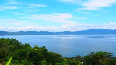
There are several beaches between Accra and Tema, including Prampran, but beach fanatics are advised to travel a little further to the coastal town of Ada. The Ada Foah and Paradise beaches can be found 120 km from Accra, where the Volta River meets the ocean. Here, the fine beaches of both the river estuary and the Atlantic provide exceptional resort areas. With water sports and river trips, this is a great area in which to relax, while the waters off the coast are teeming with game fish.
For those interested in the culture and customs of Ghanaian society, a visit to the Accra suburb of Teshie-Nungua is a ‘must’. Here, local artists have made coffins in the shapes of car, aeroplanes and even animals that are now regarded as works of sculpture. Historically, a local fisherman would be transported to the next world in a fish-shaped coffin. Something that began as a special tribute to an uncle has turned into a lucrative business for traditional coffin-makers in the area as the coffins have become collector’s items.
The Greater Accra Region is perfect for tourists seeking a busy and wild Ghanaian experience. With its streets full of hustle and bustle, Accra is truly Ghana’s version of the city that never sleeps.
SHAI HILLS RESOURCE RESERVE
Shai Hills Resource Reserve is the nearest wildlife reserve to Accra, located in the Shai Hills, 50 km from the capital. This conservation area, consisting of 52 sq km of savanna, is part of Ghana’s commitment to the preservation of its natural heritage and wildlife. It is home to 175 species of birds, 31 mammal species and 13 species of reptiles.
Close to the reserve are the Se Yo and Obonu Tem caves, located in a range of spectacular rocky hills in the middle of a big area of open plains and wooded grasslands. In parts of the reserve, visitors can see vestiges of the former Shai community, whose people were forced out by rulers over a century ago.
ASHANTI REGION GHANA
Ashanti Region Thank you for taking interest in travelling to Ashanti Region “the cultural heartbeat of Ghana”. The picturesque and undulating Kumasi is the regional capital, the second largest city in Ghana and is about 150 miles inland from the Gulf of Guinea.
The Asantes (Ashantis) constitute the largest of the various subgroups of the Akan, who trace their origins partly to Bono-Manso and Techiman, in present-day Brong Ahafo Region. The Asante kingdom was founded by the great King Osei Tutu in the eighteenth century. His fetish priest, Okomfo Anokye unified the Asante states through allegiance to the Golden Stool, which miraculously descended from heaven. Okomfo Anokye planted two trees in the forest and predicted that one tree would live and become the capital of Ashanti. Hence, the name Kumasi (the tree that lived); the place in which the other tree was planted became Kumawu (the tree which died).
Although located in the heart of the forest, Asante dominion was extended by military action and political skill towards the European occupied castles on the coast to the south, and also into the dry savannah lands to the north. This led to various wars with Britain. Kumasi was captured by the British Army in 1873 (as a result of which much of the magnificent Asante gold regalia can be seen in London in the British Museum). After a final uprising in 1901, led by the Queen Mother of Ejisu (Nana Yaa Asantewaa).
Asante came into British protection and finally became a region of the Gold Coast colony. In 1957, after a period of internal self-government, the Gold Coast became the first African colony to achieve independence under the charismatic leadership of Kwame Nkrumah. The Ashantis often call their homeland Asante. The name Ashanti is an English language pronunciation misnomer for the Ashanti people. The Ashanti ethnic group is pronounced Asantefoↄ in Ashante language. Asanti literally means “because of wars” (Asa – wars; Nti- because [of]. Nana Yaa Asantewaa Queen Mother of Ejisu.
Read More
Location and Size Ashanti
Region is located in the middle belt of Ghana occupying a total land surface of 24,389 km2 (9,417 sq m) situated on the semi-island exclave Ashanti land. The indigenous people of Ashanti (Ashanti region) are known as Asantes. The region occupies 10.2% of the total land area of Ghana and is the third largest of 10 administrative regions. It lies on longitude 0.15W and 2.25W, and latitudes 5.50N and 7.46N.
Market
Famous for gold, cocoa and cloth production, the Ashanti Region also has the largest open-air market in West Africa, at Kejetia. Tourists soon realise that haggling is an accepted part of trading in Ghana.
Kumasi is ringed with villages famous for their artisans and handicrafts, including woodcarving and kente cloth. The traditional kente cloth is woven by men of the Ashanti tribes. The Ashanti are known for their dazzling and bright patterns, geometric shapes and bold designs interwoven in silk and cotton. Referred to by the Akans as ‘nwentoma’ (meaning ‘woven cloth’), the kente cloth originated in the Ashanti Kingdom and is still one of the region’s greatest exports.
Local people choose the sacred cloth for their names as much as their colours and patterns. A visit to the royal kente weaving village of Bonwire is recommended.
The Ashanti Region, known as ‘ the land of the golden stool’, is also home to the most important gold mines in Ghana. Visits can be arranged to the town of Obuasi, 50 km south-west of Kumasi, which still has an air of the 1890s gold rush.
Rainforest
The Ashanti Region is in a vast tropical rainforest belt dominated by impressive forest, large cocoa farms and picturesque settlements. Although is the largest and urbanised region, Ashanti is also one of the most beautiful regions in Ghana and a great area to explore the unspoilt natural environment. For birdwatchers and butterfly enthusiasts, both the Owabi Wildlife sanctuary and the created lake Bosometwi are well worth a visit. Walkers will love the Bobiri Forest Reserve and its arboretum, the Bomfobiri Wildlife Sanctuary with its seasonal waterfall and hills around Lake Bosomtwi. Forest wildlife, including monkeys, buck and clouds of butterflies, can be seen all over the region.
The Ashanti Region is the cultural heartbeat of the country with numerous festivals. Among the best known are the Akwasidae, Papa, Kente, Nkyidwo and Adae Kese festivals. These religious events commemorate past leaders and heroes of the Akan. Although they are dead, their spirits are believed to be alive and to take an interest in the affairs of the living, watching their actions and consulting with them. The Akwasidae festival attracts people from all walks of life, especially those in the diaspora, fetching income to those in traditional wares such as kente cloth and woodcarvings.
Visitors can also participate in other traditional events such as funerals and naming ceremonies. Funerals, usually held on Saturdays, are spectacular events in Ashanti with displays of drumming, dancing and pageantry, often with thousands of mourners in traditional red and black. Meanwhile, child-naming ceremonies are occasions for (amicably) settling individual and family squabbles.
Entertainment
Throughout the Ashanti Region, and especially in Kumasi, guests will find welcoming hotels and restaurants and first-rate entertainment. Sporting facilities are available in the urban areas, while fishing can be enjoyed on the lakes and rivers.
WESTERN REGION
The Western Region of Ghana, adjoining the border with Cote D’lvoire, presents a striking contrast between ancient and modern. The Region includes also some of the most fertile land in Ghana, and the roads are lined with rubber and cocoa plantations and farms.
For the tourist, the forts and castles are a magnet, as they reflect the diversity of building styles that were employed by colonial traders. Of particular interest must be Fort Appolonia at Beyin, and Fort Metal Cross at Dixcove. Many of the castles overlook some of the best beaches in Ghana.
The Festival of Kundum is celebrated from August to November by the Region’s coastal people, and moves from town to town every week. Traditional drumming and dancing feature prominently.
Because the Region is so fertile, farming is a major part of the people’s life. The larger farms are happy to welcome visitors (usually by prior arrangement), and on some, such as some of the cocoa farms, you can see the full operation from the growing of the crop to the harvesting and processing of the crop for market.
The Region was one of the earliest to mine for gold and other minerals, and several of the mines welcome visitors (by prior arrangement). Tarkwa is the centre of the Region’s mining industry.
To discover the Western Region is to discover an area that reveals many of the diverse attractions of Ghana.
PLACES TO GO IN THE WESTERN
The village on Stilts of Nzulezu
An amazing village where life goes on in the centre of Lake Tadane, just 90km west of Takoradi. The houses are built on stilts, and traditional village life adapts to the watery conditions. The excursion from Beyin involves a walk through the reeds at the lakeâ’s edge, and a trip in a dugout canoe to the village. The village welcomes visitors every day except Thursday, which is a sacred day.
The Beaches of the Western Region
Western Region is famous for some of the best beaches in Ghana. Just the right spot to relax after a tour. Some of the most popular are:
- Busua Pleasure Beach – only 5km from Fort Metal Cross.
- Sports Club beach – behind the Atlantic Hotel in Takoradi.
- Ajua Beach – just 200 metres from Dadowa Lagoon.
- Princesstown Beach – off Takoradi/Elubo Highway.
- Miamia Beach – a secluded beach with rocky coves, perfect for picnics.
THE UPPER WEST REGION
The Upper West Region has a land area of 8,842 square kilometres (3%) of Ghana’s total. The Dagarba, Lobi, Sisala, Vagla and the Wala, all of who speak distinct languages, inhabit this region.
Total population of the region, which comprises five administrative districts – Jirapa-Lambusi, Lawra, Nadawoli, Sissala and Wa, – is 573,873. It is the gateway to Ghana from Burkina Faso, which is a traditional crossroads for the Trans-Saharan trade routes.
An exciting introduction to Ghana, much of the landscape is broad savannah grasslands, dotted with the strange-looking baobab trees, or striking Sahel terrain. In the villages, with their distinctive round huts, communal activities go on as they have for generations. The principal border posts from Burkina Faso are found at Hamile, Kapulima. Paga and Kulungugu.
The Upper West Region has a different feeling, as a more traditional region. The capital of the region is Wa which is also the seat of the Wa Naa, Paramount Chief of the Walas. The magnificent palace still stands as stately as it did when it was first built in the 19th century. The uniquely styled traditional village houses of round mud-walled structures connected by walls forming large compounds are well adapted to the demanding climate of this region.
Gbelle Game Reserve, located 17km south of Tumu, is an important sanctuary for endangered species of wildlife, as well as hippos, elephants and bucks. Birdwatchers consider this an important habitat for indigenous and migratory birds. Although a great deal of development is taking place in these regions, access to outlying areas can be difficult at certain times of the year and during and after heavy rains.
Read More
Refuge
Ancient caves are another feature of the Upper West Region. The caves in Bulenga, Dahili and Sankana were places of refuge for people fleeing the slave raiders. Actual slave camps can be found at Pizaga and Dolbizon and a slave market at Kassana. The region is an excellent showcase for nature and wildlife. The Wechiau Hippopotamus Sanctuary is a unique community- based project and a haven for hippos, reptiles and birds. The sanctuary, located in the north-west corner of the Upper West Region, protects and preserves the wildlife and the environment of a 40 km stretch of the Black Volta River. The river is home to one of the two remaining hippopotamus populations in Ghana and has had marked success in providing tourists with a unique and unusual eco-travel experience. South-west of Wa, visitors can spend the night in the Hippo Hide Tree House and hear one of the finest dawn choruses in Africa.
Visitors can also tap into the culture of the region. As in the rest of Ghana, festivals are a way of life in the Upper West Region. On these merry occasions, local people and their chiefs dress in colourful smocks and hold durbars in the course of the celebrations. Most notable is the Paragbiele Festival, held by the Tumu people in the last week of January until the first day of February. There is a show of farm produce, together with music and dance, as a way of thanking God and the ancestors for their guidance over the farming season. Other festivals include the Willa, Zumbenti, Kakube and Kobine.
By contrast, the Dumba festival is held by the Wala people to usher in the New Year. There is a ritual to assess the physical fitness of the chief and whether he can continue to rule. During the event, the chief must jump over a tethered cow without any part of his body or clothes touching it. If the chief fails, it is a bad omen that he is weak and should no longer rule.
Local crafts are very much on display at the festivals but can also be seen in day-to-day surroundings. The Upper West Region is home to a variety of crafts that include spinning, weaving and smock designing as well pottery, blacksmithing and carving. Visitors can also see xylophone and other musical instruments being made.
Architecture
The distinct style and architecture of the region are similar to that of Upper East. The main difference is that rooms in this region are mostly rectangular, while those in the Upper East are predominately round. The conventional village houses, built mainly of mud, are well adapted to the demanding climate. The best way to reach the Upper West Region is to fly from Accra to Tamale and travel onwards by road using the state-operated bus.
Gbelle Game Reserve
Located 17 km south of Tumu, the Gbelle Game Reserve and a bird sanctuary for endangered species of wildlife within Ghana. The reserve is also home to buffalo, hippo, elephant, buck and the country’s largest herds of roan antelope. Birdwatchers consider this an important habitat for indigenous and migratory birds.
Attractions
- Wechiau Hippo Sanctuary.
- Gwollu Slave Defence wall.
- Nakore Ancient Mosque.
- Gbelle Game Reserve.
- Wa Naa’s Palace.
UPPER EAST REGION
Upper East Region The Upper East Region is located in North Eastern Ghana and is the second smallest of 10 administrative regions in Ghana, occupying a total land surface of 8,842 square kilometers or 2.7 per cent of the total land area of Ghana. The Upper East regional capital is Bolgatanga, sometimes referred to as Bolga. Other major towns in the region include Navrongo, Paga,Garu Tempani,Pusiga, Binduri,Fumbisi, Tongo, Bongo, Nangodi Bawku and Zebilla.
As the traditional crossroads for trans-Saharan trade routes, the Upper East Region, in the north-eastern corner of the country, is the gateway to Ghana from Burkina Faso and Togo. The Upper East Region is an excellent tourist destination in its own right, offering visitors an exciting introduction to Ghana.
With a population of 1million, it is the second-smallest of the country’s 10 administrative regions. The regional capital, Bolgatanga- locally known as Bolga- has always been a meeting point for traders from Mali and Burkina Faso traveling south to Temale and southern Ghana.
Read More
GEOGRAPHY Location and size
The Upper East region is located in the north-eastern corner of Ghana. It lies between longitude 0° and 1° west, and latitudes 10° 30’N and 11°N. The region shares boundaries with Burkina Faso to the north, Togo to the east, Upper West Region to the west, and the Northern Region to the south.
The Upper East region is divided into 10 districts and 3-Municipals assemblies each headed by a district/municipal chief executive.
Beautiful Handicrafts
Bolga is a center for farmers, livestock and handicrafts including straw hats, baskets, cloth and jewellery. The twice-weekly market is the perfect place to meet traders from all over the region and to bargain for basket ware, leather goods and traditional clothing.
The region’s many exciting visitor attractions include the Paga Crocodile pond, the Bolgatanga Museum and the Kulungugu Bomb site, where an attempt was made on the life of Ghana’s first presidents, Dr Kwame Nkrumah. Other places of interest include the three-point elevation at Pusiga, the Tongo Hills and the mud-built Navrongo church, with its beautiful decorative designs by local artisans. A speciality in Bolgatanga is hand-spun fugu cloth, which visitors can buy in the markets.
The area is home to various ‘must see’ place of culture and history. They include the archaeological treasures of the River Sissili Basin, the ghostly whistling and drumming Tongo Rocks at Pwalugu and Chiana, the Awologo-Tango at Bongo, the wall decoration at Tilli and the Naa Gbewaa Shrine. Also worth a visit is the Sandema in Builsa where Builsa warriors captured and killed the slave raiders Samori and Babatu to mark the end of the slave trade in northern Ghana.
Visitors can also see the Paga-Nania slave camp, the mystery dam of Kayoro called Kukula, the Gbelle Game Reserve, the Sombo Bat Sanctuary and the Nasaga Game Reserve, just 8 km from Burkina Faso and Paga.
The region is host to many festivals throughout the year, most traditionally linked with a good planting season or a good harvest. Festivals such as the Feok, Willa, Kakube, Azambene, Gologo and Fowl draw many tourists to the region. The Samanpiid festival is a particularly large event held by the Kusasi people in the Kusaug traditional area in the harvest season.
Distinctive Buildings
Villages have distinctive building styles that have evolved through the generations. The unique round huts of the Upper East Region are a key part of the visitor experience along with its communal activities that are part of a long tradition. Only 21 percent of the population live in towns, while the remainder lives in widely dispersed rural settlements. As the least urbanised area in Ghana, the Upper East Region offers a peaceful gateway for visitors.
World’s Friendliest Crocodiles
Crocodiles are usually regarded as wild and sometimes dangerous creatures, but visitors to the town of Paga, on the border with Burkina Faso, can visit a sanctuary where the crocodiles actually coexist harmlessly with humans.
However, the crocodiles came to make their home in a large pond in a landlocked area has always been a mystery. Yet the crocodiles within the sacred Chief’s Pond are supposedly as safe as any household pet and the Paga people certainly treat them as such. Young children swim in the pond and local people wash their clothes next to the lethal jaws of the crocodiles without fear. The legend is that the crocodiles embody the souls of departed villagers. It is an offence to harm, kill or show disrespect to the crocodiles. Under the supervision of custodians, however, visitors have an opportunity to sit on the back of a crocodile or hold its tail. Astonishingly, no one has ever been harmed by any of the 110 crocodiles in the sanctuary. Paga is an excellent starting point for visitors seeking a wild African experience.
Attractions
- Paga Crocodile Pond.
- Tongo-Tenzug Shrine.
- Sirigu Art And Pottery Village (SWOPA).
NORTHERN REGION
The history of Northern Region as part of the modern state of Ghana started with the push by British soldiers garrisoned in the coastal forts and castles into the interior to conquer and colonise the land carved out by the European powers at the Berlin Conference in 1884 for the British. By 1900 that task had been accomplished.
The eastern boundary of the British colony then called the Gold Coast, shared with the German colony Togoland, was marked by the Volta River in the south and extended north along the Daka River. This was part of German possessions until the Germans lost the World War and all their African possessions in 1919. The whole of the upper half of the country was one big region called the Northern Territories.
At independence the name changed to Northern Region. In 1960 the Upper Region was carved out of the Northern Region but the latter still remains the largest region covering one third of the land surface of Ghana.
Read More
PHYSICAL FEATURES
Northern Region is the largest of the country’s 238,540-km² landmass. It stretches across one third or 31% of Ghana (70,384 sq. km.). It shares boundaries with the Upper East and the Upper West Regions to the north, the Brong Ahafo and the Volta Regions to the south, and two neighbouring countries, the Republic of Togo to the east, and La Cote d’ Ivoire to the west. Nature and culture appears to have teamed up to divide Ghana into two very distinct parts, north and south.
A visit to the North is therefore a must if you want a complete, stereoscopic view of this beautiful country. As you travel towards the North from the Coast, changes unfold before you. From the middle section of the country, the vegetation becomes sparse as the guinea savannah of the north takes over the tropical rainforest of the south.
The land features are also low- lying and flat and the climate slightly hotter. Alongside this transformation of the natural environment, a visitor would also observe a marked difference in the cultural patterns, the most obvious being the design of the traditional houses. The physical features of the region consist of flat lands 500 feet in elevation apart from Small portions of the western area and North Eastern corner where the Gambaga/Napkanduri scarp appears like outcrops in the surrounding flatland of the Voltaian basin.
DRAINAGE
The Northern Region is part of the Greater Voltaian drainage system, which drains into the Volta Lake through White Volta, Black Volta, River Oti, Nasia River, Kulpawn and Daka, which are fairly big rivers but are hardly used as a mode of transportation. Our tropical climate means there is sunshine 12 months of the year.
It only varies in intensity depending on the two seasons, rainy and dry, which alternate from April to October and November to April respectively. In spite of the wide difference in rainfall levels between the seasons, the annual rainfall is enough to make the region the breadbasket of Ghana.
Maximum temperature level of 31 degrees Celsius occur towards the end of the dry season while night minimum temperature of 18 degrees Celsius occur in January at the height of the dry hammattan winds which blow in from the Sahara desert. The Region’s natural vegetation is Guinea Savannah Woodland characterized by grassland, clusters of shrubs, short trees and a few species of big tall trees such as baobab, kapok and mahogany.
21 forest reserves scattered across the Region protect 373,000 hectares of the Region’s vegetation together with 4,000 hectares of plantations forest. The 2,468,557 million population (2010 pop. census) of the Region are made up of non- indigenous people (Mole-Dagbon extraction about 55.2%) including expatriates; but more than 95% belong to the almost 50 indigenous tribes.
Prominent among them being the Dagombas, Gonjas, Mamprusi, Nanumba, Vaglas, Lobis, Nchummurus, Bimobas and Konkombas, Basaris, Nawuris etc. The population of Tamale, the Regional Capital is 537,986 (2010 pop. census).
About 72% of the population is engaged in agriculture, the predominant sector of the Region’s economy. The second largest employment group is composed of traders followed by small- scale manufacturers and processors. The Region is a breadbasket of the country feeding Ghanaians with the abundant harvest of cereal; rice, maize, millet, yam and livestock.
Cash crops such as cashew, cotton and especially shea butter are very important agricultural produce. The hospitality industry is expanding very rapidly especially in the Tamale Metropolis and Walewale township with a number of mid to up-market hotels with conference facilities. There are restaurants, car rentals, travel and tours and other tourism and hospitality facilities to meet the pockets of all kinds of visitors and travellers to the region as well as make their stay worthy and experiential.
The potential for mineral production is very high. The region has a wide range of mineral deposits, which could be commercially exploited. Limestone, dolomite, iron ore and gold have proven commercial quantities, but are yet to be exploited. Also important is the rock salt formation especially in Daboya.
POLITICAL ADMINISTRATION
Since 1992, Ghana has pursued constitutional rule, which prescribes an Executive Presidential system of government. All the regions have Regional Ministers as the political heads who administer the regions with the help of Regional Co-coordinating Councils. The ten Regions of the country are sub-divided into a total of 216 District Assemblies for effective Administration.
Twenty Six of these are in the Northern Region.
Below are the District Assemblies and their capitals:
District Capital Bole/Bamboi Bole North Gonja Daboya West Gonja District Damongo Sawla/Tuna/Kalba Sawla Bunkpurugu-Yunyoo Bunkpurugu East Mamprusi District Gambaga West Mamprusi District Walewale Central Gonja Buipe Chereponi Chereponi Saboba Saboba Gushegu Gushegu Karaga Karaga District Capital Kpandai Kpandai Nanumba North Bimbilla East Gonja Salaga Nanumba South Wulensi Savelugu-Nanton Savelugu Tamale Metro Tamale Tolon Tolon Sagnarigu Sagnarigu Kumbungu Kumbungu Yendi Municipal Yendi Tatale / Sanguli Tatale Zabzugu Zabzugu Mion Mion Mankarigu/ Moagduri Yagaba
All the district capitals are connected to the national electricity power grid. They have water supply even though not all have pipe borne system and are linked to a national telecommunication network. The region also has a teaching hospital in Tamale, other hospitals in the districts as well as Polyclinics, health Centres and CHPS compounds all over the region.
There is therefore adequate health coverage at all tourist sites to cater for the health and emergency needs of tourists and visitors to the region. The region is one of the safest places for tourists and visitors as it has one of the lowest crime rates in the country. TAMALE Tamale the regional capital, is the 4th largest regional capital and reputed to be fastest growing city in West Africa.
It is the transport hub and commercial nerve centre of the whole Northern Ghana. The Central business district has been transformed into a bustling, modern commercial centre. Bicycle lanes (the only one in the country) street lights, pedestrian walkways, traffic lights and other public utilities have attracted more private businesses such as supermarkets, hotels and restaurants, nightclubs, internet cafes and others into the Metropolis.
The rest of the region especially the district capitals all have their share of improved infrastructure. However, most roads in-between towns are not tarred but mostly accessible.
ACCESS TO THE NORTHERN REGION AIR
Air access is also available to the region from Accra. At present, the airport handles a number of domestic flights. International Air flight landings cannot be made there. However, the Tamale airport is being upgraded currently to handle international flights which will greatly improve commercial and business activities not only within the region and the country but also the sub-region as a whole.
An airstrip in good condition exists at Mole National Park. Antrak Air, Starbow and Africa World Airlines (AWA) are some of the main air transport companies operating in the Northern Region.
ROAD TRANSPORT
Access to the Northern Region is provided on the major highway routes to Tamale from the south and north. One can get to Tamale from the south using the Accra- Kumasi- Kintampo road or the Accra- Hohoe-Jasikan to Bimbilla road (Eastern corridor).
The region has a total road network of 2,458kms of which about 700kms are tarred and 1,181kms have a gravel surfacing. About 25% of the roads are considered to be in good condition, 23% in fair condition and 52% in poor condition. The route which serves Mole National Park is currently tarred and in very good shape. Fufulso-Sawla Road (popularly called the Damongo/Mole road)Bicycles and motor bikes are widely used in the Northern Region.
VOLTA LAKE TRANSPORT
The navigable waterway of Lake Volta extends about 224 nautical miles or 415 kilometers from Akosombo to Buipe with stops at Yeji and other places along the river. The Volta lake Transport Company (VLTC) is responsible for the development and operation of transportation on the lake.
From the Volta region in the south, one can get to the northern region by ferrying from Akosombo to Yeji and then to Makango before traveling by Metro Transit bus from Makango to Tamale.
AN ADVENTURE’S DREAM DESTINATION
There are three reasons to visit Northern Region.
• Rich historical, natural and cultural attractions
• The circuits in one region
• Hospitable people, tropical climate and open country
NORTHERN REGION – A DIFFERENT GHANA
The uniqueness of the attractions in the Northern Region has been the main draw for tourists who are streaming to the capital, Tamale in numbers. The young and the adventurous have found a different and unique destination yet to be discovered by mass tourists.
HISTORY OF THE PEOPLE OF THE NORTHERN REGION
The Komas were probably the earliest known inhabitants of the area now known as the Northern Region. Even though the Komas have disappeared as a distinct tribe they have left behind a treasure trove from their period. Archaeological diggings in West Mamprusi have unearthed terra cotta figurines, pottery and dress accessories from the first half of the last millennium.
Some of these can be viewed at the Museum showroom in Bolgatanga. The Gonjas are also reputed to have been among one of the earliest indigenous tribes to settle in present day Northern Region just like the Nchummurus of Brong Ahafo and the Lartehs, and Efutus of the Eastern and Central regions respectively.
In the early 1600s one of the greatest kings of ancient Ghana, Ndewura Jakpa created the Gonja kingdom, which is still one of the largest kingdoms in Ghana today. His reign from 1622 to 1667 saw one of the strongest kingdoms in Ghana.
The Dagombas call their kingdom Dagbon. The overlord or king of Dagbon is called the Yaa Naa and the seat of his Paramouncy is Yendi. They trace their ancestry to Zamfara in present day Nigeria from where their common ancestor, Tohazie or the ‘Red Hunter’ traveled to Biung. Gbewa, Tohazie’s grandson settled in Pusiga in Upper East Region from where his sons Sitobu, Tohagu and Mantambu migrated southwards and founded Dagbon, Mamprusi and Nanumba kingdoms respectively.
And from this colourful and proud history we have inherited a basketful of historical attractions. The Northern Region is a place for lovers of nature. Its natural features of scenic and beautiful vegetation contain some exotic species of flora and fauna and offer a different experience of adventure in nature and wildlife.
The savannah vegetation enhances the fantastic panoramic view from the Gambaga/ Nakpanduri escarpment and Karimenga hills while offering opportunities for hiking, trekking and canoeing. Nothing however, compares to the Region’s rich nature reserves. The Mole National Park for example is one of the largest and best developed National Parks in West Africa.
Bui National Park, the other National Park in the region, does not boast of such services, but the variety of wild life especially the resident Hippos makes it a place to be for adventure. The variety of birds at the Zongchagni oxbow lake, Daboya, Sabari, Nasia and the nature reserves are beginning to attract ardent bird watchers to these sites.
Forest reserves and tree plantations have been created by the Forestry Department in Tamale, Yendi, Damongo and Bole, and they add a touch of tropical forest to the natural savannah vegetation of this region. The sacred groves are traditional nature reserves created around shrines. These groves shelter medicinal herbs, rare and near extinct plants among many exotic plants.
The Jaagbo shrine and the Kalvogu sacred groves are the best known of sacred groves in the Northern Region, which have attracted the attention of UNESCO.
HISTORICAL NORTH
Legacies of the region’s historic past are also on offer for visitors with special interest. For the African in the Diaspora searching for his roots, castles on the coast may serve as the remaining reference points of departure for their ancestors, but the Northern Region is the most likely place to trace his ancestry.
Nowhere in the country can you find more ancient slave markets and relics than in the Northern Region. The cultural features of the people in the North are as unique as they are diverse and so different from any other in and around the country. These include festivals and religion. Salaga for example was described as the emporium of West African trade at the height of its glory.
BUIPE
By the main north-south highway from the national capital through Kumasi you cross the Black Volta into the Northern Region at Buipe which is also the terminal port of the Volta Lake Transport Service from Akosombo in the south to the north.
In Buipe (Gbipe) precisely at its old site is located the tomb of the Great NdewuraJakpa the Gonja King who conquered, founded and consolidated Gonjaland. This tomb has now been redeveloped into a major tourist attraction.
A visit to the site will involve extensive interpretation on the design and rational for the tomb and its historical and heritage significance.
The northwest journey brings the visitor to Damongo, the District Capital of West Gonja and the traditional capital of the paramount chief of the Gonjas with the title Yagbon Wura. Two very important stops or detours can be made before getting to Damongo. DABOYA: This town across the White Volta off the main road to Damongo is perhaps one of the most unique craft villages in West Africa.
It is a town synonymous with Fugu (smock) the hand- woven striped cloth worn mainly by the people of the northern part of Ghana. From the spinning of the yarn to the weaving strips, every stage is done by hand and it is the main occupation of the majority of the inhabitants. Daboya is also accessible from Tamale through Tolon
At Larabanga
The ancient mosque and mystery stone have featured in every tourist guidebook. The people of this village, known as the kamaras, are descendants of the Muslim cleric who gave NdewuraJakpa spiritual protection during wars.
Legend has it that he threw a spear and where it landed was where he built the mosque some 400 years ago. He also left behind a Quran just as old as the mosque reputed to have been sent down by an angel.
This trio of mystics is completed by a stone, which cannot be moved. Thus the road from Larabanga toward the Upper West Region had to be constructed around the stone leading to sharp meandering bends around the stone.
Larabanga Mystic Stone
BUSUNU
Slave raiders mainly from the Sahel Region of Mali and Niger raided and terrorized tribes in Gonjaland. One of the most notorious was Samori. In 1896 a dispute over the succession to the Gonja Paramountcy between the Kong and Bole Divisions of the Gonjaland turned into a war.
The Kong people then sought the help of two infamous slave raiders – Samori from Guinea and Babatu from Côte d’Ivoire. These two mercenary groups massacred a large number of people before they themselves were defeated at the Battle of Jentilpe where a mass grave still exists. The Bole division eventually won the war when the remnants of the Gonjas retreated to Busunu where they made a standoff and defeated the mercenaries.
ECOTOURISM
If you want adventure away from the well-beaten track then the northern region is the ideal destination for you. The combination of the variety of eco- tourism assets, relics of the slave trade against the background of diverse and very different culture is providing the draw for the increasing number of the energetic and courageous finding their way to Tamale.
MOLE NATIONAL PARK
Mole National Park is the country’s premier park for game viewing and perhaps the most important single attraction in the northern region. It was established in 1958 and re- designated as a National Park in 1971.
Covering about 4577 kms. of undulating terrain with steep scarps, pristine guinea savannah vegetation and gallery forest along the rivers and streams, the park is home to almost 90 animal species notable among them being elephants, buffalo, roan, kob, hartebeest, waterbucks, warthogs, and 4 primate species. Lions, leopard and hyenas also occur and over 300 bird species have been recorded.
The park is largely located in the West Gonja district, about 143km (96miles) west of Tamale, on the Tamale-Wa trunk road. How to get there: A Metro Transit Bus runs a daily trip to the Park, Wa and Damongo. The Wa bus leaves in the morning about 5:30am daily (alight in Larabanga and charter a taxi); while the Damongo bus leaves in the morning daily at 6am (taxis abound to charter to the Park).
A private transport operator A.Y. Transport runs daily trips from Tamale to the park at 1pm – the station is located behind the Kaladan Park on the Picorna Hotel road’. You can also drive there with your private vehicle. One could also rent vehicles Tamale. GPRTU buses also run daily services on the road to Damongo and Wa.
The park has a 33-room hotel, which has a total of 87 beds. All rooms are en suite. There is also a restaurant offering local and continental cuisine. You can also relax after the morning safari by the poolside. Game viewing (safari) at the park is at 6:30am and 3:30pm. Visitors are provided with armed guides.
However, visitors may be taken on safari at any time between the 6:30am and 3:30pm on request Visitors to Mole also have the opportunity of exploring an eco- village at Mognori, which undoubtedly offers a true eco-village experience in tune with nature. Located 15 km on the south eastern boundary of the Mole National Park, the “Eco–Village experience” involves experiencing culture and traditions.
Major activities one can enjoy include
• Day and overnight canoe safaris; for adventurous minded visitors
• Mognori village walk; you will learn about and participate in the traditional healing methods, shea butter processing and many more. Buffaloes in Mole National Park
KPARIA WATERFALLS AND COMMUNITY TOURISM
Kparia is a community located to the north of the Mole National Park in the overseas area of the North Gonja District. There is a perennial waterfall located very close to the community but within the Park. Accessibility is currently difficult except for explorers and drifters. However, it holds great potential to attract tourists to the community and the waterfall.
Kparia tourism circuit has diverse tourism products which makes the attraction very appealing and fulfilling to both eco tourist and cultural tourists. These include the waterfalls (Kparia and Polzen within Mole Park), caves, bird watching, game viewing, historical settlement and community cultural heritage.
Another site visitors to the Northern Region cannot afford to miss is the Sonyo Community, showcasing “Traditional lifestyle and architecture”. Located 15km east of the district capital, Bole, on the Bole Secondary School road, Sonyo has a unique traditional architecture built in the ancient times to protect the community from their enemies.
Interestingly, most of the households do not have entry points at the base of their houses. They are only accessible to each other by walking on top of the roof using traditionally manufactured ladder to ascend and descend into the households. A Journey westwards takes the tourist some 100km from Larabanga to Bole.
The journey passes through Jentilpe and Nyange, the original capital of the Gonjas. Some interesting historical and heritage sites to be seen are three ancient mosques at Bole, Banda Nkwanta which are built in the same architectural style as the Larabanga mosque and the Royal Mausoleum at Makuma. It is also the best opportunity to see the famous Lobi culture in any of the Lobi villages, their architecture, pottery and other crafts.
The bold and curious can consult the powerful Kipo shrine at Sonyo. The star attraction in the Bole district remains the Hippo Sanctuary within the Bui National Park. A journey in a 4×4 vehicle takes 45min to the banks of the Volta River at Ntereso.
With the help of a guide and a hired canoe you can paddle to the grazing hippos some 5km downstream. However, with construction of the Bui Dam, this is likely to affect the hippo sanctuary and other flora and fauna located in the area. Kulmasa is also noted for its traditional myths and beliefs.
It is located in the Sawla-Tuna-Kalba district 55km from Sawla, on the Wa-Kumasi highway. Kulmasa’s traditional myths and beliefs are centered on crocodiles. Visitors to kulmasa would experience how the locals co-exist in harmony with the crocodiles.
BIRD WATCHING The Northern Region attracts a lot of birds because of certain favourable conditions.
The abundant grains produced here together with the wild grains of the savannah grass, water bodies such as the wetlands behind irrigation dams, the ponds and rivers are feeding grounds while protected areas like forest reserves and nature parks give them sanctuary.
Also areas around the Mole and Bui, the wetland around the Nasia, River Oti at Sabari and the Zonchagni ox-bow lake near Savelugu are fertile feeding grounds for birds. Between Nasia, Karimenga and Daboya bird watching is popular. HOW TO GET HERE: A flight from Accra to Tamale takes just about one hour.
The journey by road through Buipe continues to Tamale on one of the best highways in Ghana. The coaches of the intercity STC and other private transport companies take nine hours. The experience starts with the Ancient Slave Trade relics in the Salaga.
Another route to Salaga is through Makango where a ferry carts goods, vehicles and passengers from Yeji on the Brong Ahafo side of the Volta Lake to Makango. These are either coming from Kumasi by road or from Yeji by Volta Lake Transport Company passenger vessels originating from Akosombo.
THE SLAVE TRADE HERITAGE
Anyone of African descent domiciled abroad who is looking for his roots needs to go beyond the castles on the coast. They have to come to the northern region specifically to Salaga where the biggest of the slave markets of the 17th to 19th century was located.
Some of the relics of that period, which remain virtually intact in Salaga, are the hundreds of wells, which supplied water to the millions of merchants, slaves and beasts of burden; the market place, the bath troughs and the warehouses. Other towns with remnants of the slave trade include Yendi, where the tomb of Babatu, one of the notorious slave raiders can be found near his house.
His descendants still have his arms and amulets as heirloom. The Dagombas have a truly turbulent history and this is reflected in sites to be seen around Yendi. At the outskirts of the town is a hollowed tree with a rock nearby. The Dagombas fought several wars defending themselves or expanding their territories.
In the centre of the town are cemeteries for Germans and British who colonized that part of Ghana during the scramble for Africa. The cemeteries are an indication that they did not have it easy. At Adibo Dali, near Yendi is the field of a battle fought by the Dagombas against the Germans in 1890. Slave well site at Saakpuli in the Savelugu District.
The graves of the Dagomba warriors are close by the field where they fell and a tree on top of which their General directed their strategies. Side attractions in the south eastern trail are the Greenwich Meridian line in Yendi and the bird watching site at Sabari on the Oti River.
SITES IN AND AROUND TAMALE
Tamale is a relatively new town which at the turn of the last century was just a cluster of villages known mainly for the numerous shea butter trees- the ‘tama’ – from which it got the name Tamale. In 1907 it became the capital of the Northern Province of the British colony of the Gold Coast. The north played a very important role in the 2nd world war.
Two of the vestiges of the period are the old barracks and the old airport, which were built for military purposes. In addition to these is the monument to the royal wedding between King George V and Queen Elizabeth I located in the Gardens opposite the Jubilee Park.
The regional capital is also the commercial hub with virtually all the financial institutions operating and offering the services required by the travelling public. Some of the major banks include Standard Chartered Bank,Barclays Bank, GCB Bank, Agricultural Development Bank, National Investment Bank, Bank of Africa, Fidelity bank, Guarantee Trust Bank, Stanbic Bank, HFC Bank, EcoBank Ghana, UniBank, Access bank, Zenith Bank including the Bank of Ghana to mention a few.
All the insurance companies are also operating here to cater for your needs. All the banks also offer foreign exchange services. Even though the region is not a main stream shopping centre, there are shopping malls and outlets that can cater for the shopping needs of travellers and tourists alike.
For the cultural tourist, Jakarayili and Kukuo, suburbs of Tamale will be rewarding, as they are centres for traditional weaving and pottery and other community life style encounters. Weaving can also be observed at the Tamale and Aboabo Markets and recently along the major roads in town. Some Vernacular architecture in the northern region
Traditional Architecture of the North The north is noted for leather ware and the place to see the complete chain of activities involved from tanning raw cowhide to finished sandals, bags, belts or boots is Zongoni along the Buipela road. The artisanal blacksmiths who make simple tools, musical instruments and bangles can be found at Sabongida.
Shea butter is the raw material for body creams. Production of this important cream from the shea fruit is undertaken in villages around Tamale and all districts. All these traditional crafts and products can be bought in all the markets around the town but the best places to see these crafts are the Centre for National Culture and Aboabo Market.
In spite of its status as the fastest growing city in West Africa and the fourth-largest regional capital, Tamale is unique in the coexistence of centuries’ old traditional culture and modernity, typified by the modern office blocks standing side by side with old round huts with conical thatch along the major roads. Other cultural features to be observed in Tamale are the numerous shrines spread in all major traditional quarters such as Choggu, Nyohini and Vittin.
The “Pulipuon” tree at the Tamale Teaching Hospital lends credence to the power of shrines as recounted by adherents. However, to get a more practical benefit of shrines, which are usually only used for divination you have to travel some 24km to Tali near Tolon where a sacred grove has been used to create centuries old virgin vegetation around a shrine, the Jaagbo shrine, which serves as a sanctuary for birds and wildlife. A mystery tree near the Jaagbo shrine is reputed to have been climbed by a warrior on a horseback.
The hoof prints of a horse are still visible on the tree. To get a better insight into our culture groups can arrange to pay courtesy calls on any traditional chief, such as the chief of Tamale, the Dakpema; the Yaa Naa’s representative, the Gulkpe Naa, the Lamashegu Naa or the Sagnarigu Naa. Better still get lessons in culture and dance at the Centre for National Culture or at the Youth Home in Tamale. Research into the culture of the people can also be done at the Tamale Institute for Cross Culture Studies (TICCS).
It is not by any means all tradition and culture in Tamale. The central business district is a modern avenue of shops lined along carriageways and so you have the choice to shop for all your needs or sit in a bar for a cold drink or eat in a restaurant or a ‘chopbar’- traditional catering outlets where you can savour the local delicacies like TZ, Wasawasa, Tuugbani etc.
There are a few swimming pools and tennis courts where one can cool down from the heat and exercise if need be. Savelugu District is located 24km north of Tamale. It is accessible by a first class road and it offers cultural, natural and historical attractions for travelers. This is the district from which the cradle of Dagbon kingdom had its first capital at YeniDabari. The shrine of NaaSitobu, A welcome visit to our traditional palaces, founder of Dagbon can be found here.
Other important names associated with the Dagbon kingdom include NaaNyagse who conquered most of present day Dagbon and NaaLuro who consolidated the kingdom. Diare in the Savelugu District is the cradle of the Dagbon Kingdom. The founders of the Dagbon kingdom, NaaSitobu and NaaNyagse made YeniDabari the first capital of the Dagbon kingdom. Some relics of the founders, the shrine, NaaNyagse’s grave, his hoe and some of his arms of war can be found in the district.
There is an ox-bow lake located in an idyllic setting near the White Volta at a place called Zongchagni. There is also a rapid, cascade and an island with sandy beaches surrounded by beautiful trees. The water bodies and grain-laden fields attract some of the most exotic birds to the district. It therefore provides a scene for bird watching.
Tolon and Kumbungu Districts are located to the southern part of the region and are about 24km from Tamale respectively. The districts pride themselves in natural, historic and cultural attractions. The scenic beauty of the savannah vegetation is best seen in the flat low lying landscape of these districts and a shea butter plantation provides beautiful afforestation near Kumbungu.
The Bontanga Irrigation Dam provides water for rice cultivation and fishing. The Chirifoyili dam is home to crocodiles and is also used for small scale dry season irrigation. Cultural attractions in the district include the palace of the Chief of Tolon (Tolon-Naa) which is a splendid combination of traditional and modern architecture. Farmers use raw materials such as guinea corn stalks and other stalks to make strong and handy baskets. Weaving of smocks (Fugu) and pottery is done by the village folk and sold in Tamale.
The Savannah Agricultural Research Institute (SARI), the University for Development Studies (UDS) at Nyankpala and the Ghana Danish Community Programme (GDCP) at Dalon are major institutions of learning and research in the district. The main campus of the only University in the North – University for Development Studies is located in Tamale, with other campuses in Nyankpala, Navrongo and Wa. The school offers undergraduate, graduate and PhD programmes to both local and international students.
Other institutions include the Tamale Polytechnic, Teacher Training Colleges and the technical University College of Tamale. Main Administration Building of UDS in Tamale
SAAKPULI SLAVE SITE
Saakpauli is a village 7km off the Tamale- Bolgatanga trunk road at Disiga. This village was one of the several slave markets in the northern region. The market took place under a large baobab tree, which still stands today. Other relics are the old wells used by the people and slave merchants for cooking and drinking. Others include the remains of the stone foundation of ancient Saakpuli settlements. Traders from the north mostly Muslims exchanged tobacco and slaves for kola nuts and other merchandised goods from the south.
In the 19th century, Babatu and Samori the notorious slave raiders were known to have sold slaves at the market when they raided communities in the north, south and upper territories of Ghana and Burkina Faso.
WEST MAMPRUSI DISTRICT (WALEWALE)
The hilly, physical features coupled with the rolling savannah vegetation make the Karimenga area one of the most scenic landscapes. Trekking in this environment with boat rides on the White Volta and Nasia is a treat for the Nature lover.
WETLANDS
West Mamprusi District is famous for its ‘overseas’ area. This is an area crisscrossed by many rivers, which over flow their banks and create a vast lake-like feature. Nasia River also creates a similar Wetland during the rainy season.
This has made the whole of West Mamprusi a thriving sanctuary for both indigenous and migratory birds. There is also spring water at Jaringa near Kpasenkpe which cascades down rocks like a waterfall. A Forest Reserve created as a sacred grove in Duu, harbour wild life.
EAST MAMPRUSI AND BUNKPURUGU/YUNYO DISTRICT Gambaga Escarpment is the highest point in the northern region.
It has breath-taking views and offers opportunities for hiking on nature trails especially at Nakpanduri where there is a beautiful small seasonal waterfall and a garden around what used to be a rest house for the first president of Ghana Osagyefo Kwame Nkrumah.
The Nakpanduri end of the scarp has some amazing steep cliff surfaces which could be potential sites for paragliding and abseiling, while the rolling hills and forest cover provides opportunities for hiking and camping. The White Volta separates the Mamprusi land from the Upper East Region. It provides avenue for trekking and boat cruises.
HISTORICAL ATTRACTIONS
Naa Jaringa Wall. Naa Jaringa was a powerful Mamprusi chief who built a mighty wall around Nalerigu as his own memorial. It was built in the 15th century allegedly with honey, milk and sometimes human blood.
Only about 50 meters of the 10ft tall wall still remains.
Naa Atabia’s Grave. The great king fought and expanded the Mamprusi kingdom. He was the greatest king of the Mamprusi.
FESTIVALS
The region has the distinction of having one major festival celebrated by all the major tribal groups Dagomba, Gonja, Mamprusi and Nanumba.
FIRE FESTIVAL
The fire festival is called ‘Jintigi’ by the Gonjas and ‘Bugum’ by the Dagombas and Mamprusis.
Jintigi Fire Festival The chiefs and people of Gonjaland celebrate it in April every year. The capital of Gonjaland Traditional Area-Damongo-serves as the epicentre of the entire celebration. Among activities undertaken to mark the festival are the procession at night with torches of fire to the outskirts of towns and villages within Gonjaland. There is Quranic recitation to forecast events in the coming year.
Special Jintigi Festival It is celebrated ahead of the main Jintigi festival. This festival is held mainly by the ethnic Kamaras whose main town is Larabanga. The main activity is the annual consultation of a Quran by the Chief Imam to predict what will happen in the coming year. The said Quran is reputed to have been sent there by an angel.
The ethnic Kamaras are descendants of a powerful Imam called Yidana Braimah. Bugum Fire Festival The Bugum Chugu (festival) is celebrated by the Dagombas, the Nanumbas, and the Mamprusi. It is held in the lunar calendar. The main activity is the procession of celebrants with torches at night amidst music and dancing. The significance of Bugum is to commemorate the search for the lost son of an ancient king.
SONYOR DENG FESTIVAL
It is thanksgiving festival to pay homage to the Sonyo (Kipo) fetish shrine at Sonyo in the Bole District. The festival is held among the Gonja worshippers of Sonyo (Kipo) shrine. It is held in the lunar calendar. The main activity is the presentation of a live bush animal usually a rabbit to the shrine. It is similar to the ‘Aboagyir’ festival of the Efutu people in the Central Region.
However, whereas with Aboagyir an antelope is caught, the Sonyo festival uses a rabbit. The high point of the festival involves the mobilization of the youth into groups like the ‘Asafo’ who enter the forest for the catch of a wild rabbit. The first group that makes the catch brings it to the high priest of the Sonyo shrine amidst singing and dancing. The animal is then slaughtered and offered as sacrifice to the gods after some rituals have been performed.
THE DAMBA FESTIVAL
The Damba is categorized into three main festivals, namely:
• Somo-Damba
• Naa-Damba
• Belkusi-Damba
The Damba Festival is a traditional festival with its origin from Islam. It is the celebration of the birth of the prophet Mohammed. The festival falls annually on the twelfth day of Rabi-ul-Awwal, the month in which the Prophet was born. ‘Somo-Damba’ also called ‘’Moulidi Nabiyu’’ which marks the birth of the holy Prophet and ‘Naa-Damba’ also known as the Chief Damba marks the naming of the Prophet.
The countdown starts with the appearance of the new moon of Rabi-ulAwwal also known as the Damba Moon. The ‘’Somo-Damba’’ is celebrated on the tenth day of the Damba moon with traditional music and dancing in front of the chief’s palace with women of every quarter of the town organizing their own singing and dancing. On the morning of the ninth day, the rice that will be cooked on the ‘Somo-Damba’ is spread amid singing praises to Allah.
Another important activity is in the evening where there are prayer sessions and sermons about the festival and a talk on Islam are held. Naa-Damba which is celebrated by the Chiefs falls on the seventeenth day of the Damba moon and is marked by colourful display of traditional costume, dances and many other activities, which includes the slaughtering of a bull provided by the chief.
In the afternoon the drummers and the people in their colourful dresses, go to the chief’s house to pay homage. During this period the Imam and the chief’s linguist lead the drummers into the palace to lead the chief and wives out in a procession. When they appear they are met with joy and jubilation.
As soon as the chief is seated, the drummers start the ‘Damba beat’. Whilst the Damba beat is being performed, the chief occasionally takes the floor to dance and people rush to present money to show appreciation. There is firing of muskets. This continues till 6:00pm when the chief retires to his palace, which gives an indication, that all is over for the time being. The next day there is the display of horsemanship to see the Damba off.
On this day anybody who owns a horse including the chief decorates it and then they ride on them to the town to greet friends and important personalities. In the evening amidst drumming and dancing, a long procession starts from the chief’s house to the outskirts of the town where the festival is rounded off.
One thing that stands out on all such occasions are the traditional clothes, the hand woven smock called Fugu. The best Fugu is made in Daboya, Yendi, Gushegu and Tamale.
KONYURI CHUGU (EID-IL-FITR) FESTIVAL
All Moslems observe this festival throughout the Northern Region. It is marked through prayers, fasting and general merry making. It symbolizes the end of the Ramadan fast.
CHIMSI CHUGU (ED-IL-ADHA) FESTIVAL
All Moslems hold it in the lunar calendar. There are general prayers, feasting and slaughtering of animals especially rams, cows, camels etc, to commemorate the sacrifice made by Prophet Ibrahim (Abraham) to Allah.
GOBANDAWU (YAM) FESTIVAL
Gobandawu marks the beginning of the new yam harvest season by all traditional areas in the Northern Region. The main activity is the sacrificial offer of yams and guinea fowls to in-laws. The significance of this festival is to give thanks to the gods for a good harvest.
PLACES OF INTEREST
CENTRE FOR NATIONAL CULTURE
Popularly called the Cultural Centre or CNC, it is located near the jubilee park in the centre of town. The Centre is the main cultural hub of the northern region where the various traditions can be learned. The Centre organizes cultural performances as well as lessons in drumming and dancing for tourists/visitors.
There is also model traditional Dagomba architecture on display. Behind the centre is a crafts market where leather and other products are on display and for sale.
TAMALE CENTRAL AND ABOABO MARKETS
The markets in Tamale sell everything from groceries to motorbikes. Visitors will find this colourful market full of hustle and bustle. Traditional Fetish Shrines Since religion is an integral part of man’s life, worshipping the supreme deity comes in different forms ranging from contemporary religions like Islam, Christianity etc, and indigenous forms of worshipping through fetish shrines dotted across the length and breadth of the Northern Region.
Notable among them are the Jaagbo Sacred Grove and Shrine at Tale, Kpalyugu shrine at Katariga, Kuntuli shrine at Yiwogu and Sonyor Kipo in the Bole district.
Kpalyugu Shrine It is located at Katariga on the Tamale- Kumbungu road. As with all sacred groves in Ghana, it is a sacred place where the gods and ancestral spirits of the people reside and yearly rituals are performed to pacify the gods and ancestral spirits.
Kuntunli Shrine It is the grave of Naa-Sitobu and located off the Savelugu-Kumbungu road.
The Yaa Naa and other Dagbon natives patronize this shrine. UNESCO adopted it years ago for preservation under its bio-diversity programme called CIPSEG.
Zin-Nyebo Shrine It is located in Tampion in Savelugu district. The shrine is known for not tolerating the collection of tolls in the Tampion market. It is situated in the market of the town. Notorious toll collectors are often chased away by swarms of bees.
Sonyor Kipo Shrine It is located at a village called Sonyor in the Bole district about 16km from Bole town.
It’s the supreme god among the gods in the Bole area. It is believed that the famous Tigari shrine derives its powers from the Sonyo Kipo shrine.
TRADITIONAL ARCHITECTURE
The architectural structure and design in the Northern Region and indeed the entire northern Ghana is unique. The compound of each household is clustered with round huts built with local materials like sand and roofed with thatch and dry straw in a conical shape. The hall in the compound is often the biggest hut in the house, which is used to house visitors and guests.
Most often, the chief’s palace is the biggest compound in the village with the tallest and most pointed roof in the village. Tourists can gain immense experience when explanation of their layouts, building functions and construction techniques are given. Even more interesting is the layout of the chief’s compound.
TRADITIONAL CUISINE
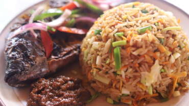
The Northern Region has an array of indigenous cuisine, which are the staples of almost all the major ethnic groups in the region. Notable among them are ‘TuoZaafi’ (TZ), which is called ‘kude’ by the Gonjas, ‘Saam’ by the Dagombas, ‘Saamu’ by the Mamprusi. Other notable cuisines are rice balls or ‘tuoshinkafkpulla’ (Dagomba), ‘tuubani’, rice and beans known as ‘waakye’ locally, yam and ‘adua’ (beans). Most of the dishes are accompanied with soups like groundnut, dry okra, green leafy vegetables like ‘aleefu’ and ‘ayoyo’ etc. the local drink is Pito, which is brewed from guinea corn.
MUSIC AND DANCE
Music and dance depict the culture of the people. Music and dance are performed on different occasions such as festivals, installation of chiefs, marriages, funerals, and holidays and even during ordinary days for entertainment. The popular dances are ‘takai’, ‘Bamaaya’, ‘Tora’, ‘Jera’, ‘Simpa’ for the Dagombas and Kpana, ‘Goobi’, Asie, etc for the Gonjas.
The Centre for National Culture has a dance ensemble, which offers music and dance lessons to people. There are other cultural troupes such as the Youth Home Cultural Troupe that offer lessons as well.
TRADITIONAL CRAFTS
Traditional crafts are well developed in the northern region and are an attraction for tourists and also a source of income and employment for the local artisans.
Handicrafts The main traditional textile in the north is Fugu. The main centres for its production are Yendi, Tamale, Gushegu, Tatale, Saboba, Bimbilla and Daboya. However, Daboya which produces the batakari-style textile is the best known of the traditionally textile villages. It is located about 61km west of Tamale.
A visit there would include a boat ride, fishing on White Volta, salt mining, bird watching and a stopover at Jaagbo shrine, UDS and SARI. Leather tanning and leather ware can be found at Zongoni in the Tamale, Bimbilla, Gushegu and Tatale. Pottery can also be found at Jakarayilli and Kukuo in Tamale as well as Bimbilla, Saboba, Tatale and Gushegu. Xylophone making can be found in Gilsiya near Bimbilla. Other crafts that are popular in the northern region are Mat weaving, Hut décor, Woodcarving and Cotton spinning.
SHEA BUTTER EXTRACTION
Shea butter is obtained from the shea tree, which grows in the wild in the north. The butter is the base material for cosmetics and pharmaceuticals. The production of the butter, which is mainly done by women, can be seen, observed or learned in all the villages in the region.
BRONG AHAFO REGION
Known as the ‘food basket’ of Ghana, the Brong Ahafo Region is located in mid-Ghana. The region serves as a transit for travelers from the South to the Northern part of Ghana. The inhabitants are warm and friendly people with diverse ethnic backgrounds.
The Brong Ahafo region has rich and diverse cultural practices which can be traced back to their ancestral roots and culture. Their unique tourist attraction sites attract many people from far and near to the region. Sunyani, also known as the green city of Ghana is the regional capital. Sunyani can pride itself as the cleanest capital city and a major conference destination.
Read More
ECONOMIC ACTIVITY
Agriculture, mining, quarrying, manufacturing, and construction services are the main economic activities in the Brong Ahafo region. Agriculture is the predominant activity and a large number of the region’s population is engaged in this sector. The region has one of the three largest cocoa producing areas in the country. The region also produces cash crops like cashew, timber, coffee, rubber and tobacco. The main food crops are maize, beans, cassava, yam, cocoyam, plantain, rice and tomatoes.
Yam production is very high in the Guinea Savannah zone around Techiman, Kintampo, Nkoranza, Yeji, Prang and Kwame Danso. There is also fishing activity along the region’s side of the Volta Lake.
BOUNDARIES
The Brong Ahafo region lies in the middle part of Ghana and is bordered to the North by the Black Volta River,to the east by the Lake Volta ,to the south by Ashanti Region, Eastern and Western Regions and to the west by the Ivory Coast (La Cote D’Ivoire). The area covered by the region is 39,557 square kilometers.
TOPOGRAPHY AND CLIMATE
The topography of the region is mainly characterized by a low elevation not exceeding 152 metres above sea level in the southern and eastern areas. The land generally rises to a height of 643 metres in Kintampo Area.
The Brong Ahafo Region has a tropical climate with high temperatures averaging 23.89oC (75oF) and a double maxima rainfall pattern. The Region has two main vegetation types namely, the moist semi-deciduous forest mostly in the Southern and South-Eastern parts of the region, and the Guinea Savannah woodland mainly in the North-Eastern portion of the region.
ADMINISTRATION
Brong Ahafo has 8 Municipal and 19 District Assemblies with Municipal and District Chief Executives (MCEs & DCEs) as political heads. They are assisted by Municipal and District Coordinators (MCDs & DCDs) who are responsible for the day to day running of the districts.
The MCEs and DCEs work under the Regional Minister who is the political head of the Region whiles, the MCDs and DCDs work under the Regional Coordinating Director. Sunyani is the administrative headquarters of the region where the Regional Minister resides.
TOURIST ATTRACTIONS IN BRONG AHAFO REGION
BOABENG FIEMA MONKEY SANCTUARY
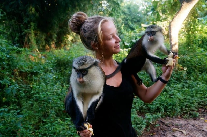
The Boabeng Fiema Monkey Sanctuary located 22km north of Nkoranza, hosts a rare breed of Monkeys which are considered citizens of the town. It is a superb sanctuary created in the then Nkoranza District in 1974 to protect the Sacred Monkeys that inhabit the forest around the villages of Boabeng and Fiema. The sanctuary is home to the black and white colobus monkeys and mona monkeys.
The monkeys are used to human beings and are found on the compounds of the villages of Boabeng and Fiema. Accommodation facilities are available for tourists who may want to spend the night or stay longer for research.
CULTURAL/LANGUAGE/ETHNIC GROUPS/TRIBES
The predominant ethnic group in the region is Akan, which includes the Bonos and Ahafos. There are however several other ethnic groups that constitute the Brong Ahafo Region. These groups include: Mo or Dagba; Nafana; Guan; Kolongo; Mande; Nchumuru;Banda.Each ethic group has its own language or dialect, festivals and customs.
There is the Brong Ahafo Regional House of Chiefs which is made up forty-six (46) paramount chiefs and three (3) divisional councils. Prominent among the festivals in the region are the ‘Apoᴐ’ of the people of Techiman and Wenchi celebrated in April, Kwafie of the people of Dormaa celebrated between October and December and the Kurubi Festival of the Wangara in Kintampo celebrated in November.
ELECTRICITY – All the municipal and district capitals are connected to the national grid.
HEALTH
There is a Regional hospital which also serves as a referral hospital; there are also several municipal and district hospitals as well as other health centers all over the region.
SAFETY/SECURITY
Brong Ahafo Region is a serene place and there is police visibility which has resulted in relatively low crime rate. Petty crime can often be avoided simply by being aware of one’s surroundings.
BUOYEM CAVES AND BATS COLONY
Hidden in a dry semi deciduous forest in the small rural community of Buoyem in the Techiman Municipality, the site offers an exciting habitat tour package of sandstone rocks and waterfalls, caves and Rosetta fruit bats.
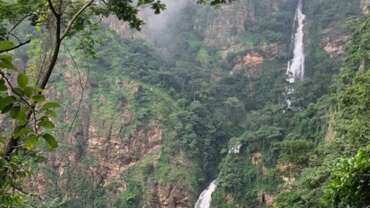
KINTAMPO WATERFALLS
At the point where the Pumpu River falls some seventy (70) metres down beautiful rocky steps to continue its journey towards the Black Volta at Buipe, is the Kintampo Waterfalls. Located 4km away from the Kintampo Township on the Kintampo-Tamale highway, it consists of three (3) unique stages which can be accessed by a footpath. The final stage offers an exciting twist as the tourist can only access the beautiful waterfall by descending a windy flight of 152 stairs. Receptive facilities are available for tourists. There is also a rest stop and a 2-star rated accommodation facility in the neighborhood of the tourist site for tourists who may need to rest or stay overnight.
FULLER FALLS
Located on the Yoko River, at Yabraso which is 7km west of Kintampo town. The Fuller Falls offers the tourist a serene environment for activities such as retreats and picnics. The cascading nature of this waterfall over rocky surfaces before joining the Black Volta makes it a delight to watch.
TANO BOASE SACRED GROVE
It is believed that the sacred grove is indeed the cradle of Bono Civilization. It is located in the Techiman Municipality. The grove served as a hideout for the Bono people during the slave trade and inter-tribal wars many, many years ago. It also serves as a place for recreation and religious activities.
BONO MANSO SLAVE MARKET
An important landmark in the history of the Slave Trade in the Brong Ahafo Region. Located at Bono Manso on the Techiman- Kintampo road, Bono Manso was the point where slaves from the north were graded and sorted. The strongest of the captives were selected and sent to the coast leaving the weaker ones in the town. To date, African Americans and other African people in the Diaspora visit the area to learn about their origin and history.
FORIKROM BOTEN SHRINE AND CAVES
Located about eight (8) kilometers off the Techiman – Nkoranza road, is a unique range of giant rocks which forms a haven like sort of shrine and caves. During the tribal wars between Asante and Takyiman in the past, it is believed that the Magic cave which is known as the biggest cave was a refuge for women and children.
NCHIRAA WATERFALLS
Wedged between the mountains of the Nchiraa settlement, the Nchiraa Waterfalls is located 30 kilometres north of Wenchi. The tourist is offered a hiking adventure on a rocky and challenging footpath that leads to the waterfall. The existence of other natural and cultural tourism within 10km radius makes the tour package exhilarating.
These include the Wurobo Ancestral Cave which is located about 8km from the Nchiraa settlement. The cave is believed to be the original dwelling place of the people of Nchiraa.
DUASIDAN MONKEY SANCTUARY
Located 10km southwest of Dormaa Ahenkro, this sanctuary hosts a rare breed of Mona Monkeys. The tourist is welcomed by the presence of these monkeys as you enter their forest-like abode. Bamboo trees form a canopy in the middle of the forest which serves as a resting ground for visitors. Monkeys can be seen swinging up and down tree branches and peeling bananas left out for them. It is quite an interesting sight to behold as the visitor gets the chance to see how monkeys carry their babies on the move.
KINTAMPO; GEOGRAPHICAL CENTRE OF GHANA
Kintampo is the geographical centre of Ghana. The exact point denoting the centre of Ghana is marked by a monument with Ghana’s coat of arms. The kintampo town serves as a transit point for travelers from the North to the South and vice versa. Due to its location, it attracts people from all walks of life.
The Kintampo town is also known for its commercial activities and the famous Kintampo Health Training Institute. Also notable in Kintampo is the British cemetery which once served as a cemetery for members of the Gold Coast Regiment.
BUI NATIONAL PARK
A park that covers 1,821 kilometer square and covers part of the Black Volta River, the Bui National Park is endowed with several species of antelopes and a variety of birds. It is also known for its hippopotamus population. The tourist can take a cruise on the Black Volta River through the National Park.
BUI DAM Located at the base of the Banda Mountains, the Bui Dam was built to improve Ghana’s energy requirements.
HANI ARCHAEOLOGICAL SITE
One of the few archaeological sites in Ghana, the Hani archaeological site is located at Wenchi. The visitor can access the site of digging and the settlement by walking about 3kms from the Hani village in the Wenchi District. Foretold to be the early settlement of the Begho people, some of its artefacts and relics from 12th Century civilization can be found in the Chief’s Palace.
BUSIA MAUSOLEUM
This mausoleum was built in memory of the late Professor K.A. Busia, a Prime Minister of the 2nd Republic of Ghana. Located on the Wenchi-Nsawkaw road about 400 meters from the centre of Wenchi town, the Busia Mausoleum displays some artefacts and personal items used by Dr. Busia. It also takes the tourist back to ancient times when those items were used.
RIVER TANO SACRED FISH
This pool houses sacred fishes which are fiercely protected by the local community who live along the River Tano near Techiman.
ASUMURA, WHITE NECKED ROCK FOWL CONSERVATION
Located in the forests of Asumura near Akrodie in the Brong Ahafo Region, is the home of a very rare species of birds which is considered as one of Africa’s most desirable birds by birders. The white necked rockfowl is lanky with a long neck and tail. It ony hops and has its mud built nest built beneath giant hanging rocks.
NWOASE OSTRICH FARM
Located at Nwoase near Wenchi, is the Ostrich farm. The Ostrich is known to be the largest living bird. It has a long neck, long legs and two toes on each foot. The tourist can make a stop at the farm to see one of nature’s wonders as the male ostrich can reach a height of up to 2.75m.
HISTORICAL BACKGROUND OF FESTIVALS CELEBRATED
APOO In Akan language, Apoo means rejection. This festival is celebrated by the people of Techiman, Wenchi and Nwoase. It is a festival celebrated to remind the people of the need to reject all evil deeds in the society. Apoo festival is celebrated for a week and includes a variety of traditional cultural activities.
On the sixth day of the celebration, there is a procession of women, children and chiefs who parade in the principal streets to drive away evil deeds of the past year by shouting and castigating evildoers in the society. The period is a time for family reunions and unity among the people.
KRISTO BOASE MONASTERY – TANO BOASE
This is a Catholic Monastery for the Benedictine Monks. The well designed facilities have an attractive landscape setting accentuated by huge rock boulders. Visitors are welcome to the monastery and a meditation retreat can be arranged for several days
KURUBI Celebrated in November by the Wangara people of Kintampo.
This festival is celebrated to unite all the people of Wangara descent in Ghana. The people meet to renew their fraternity and ties and re-affirm their allegiance to their chief. One interesting feature of the festival is a dance on stilts by virgins.
ADEKYEM
Celebrated by the Bechem people in November. Bechem which was formally called ‘Abekyese’ came into existence after Nana Tutu I and his victorious war leaders sat to share their booty or spoils at Abekyese. Legend has it that the chiefs said, “We shall divide our booty here” (yebekye mu wo ha), hence the name Bechem.
After the Gyaman war with Abo Kofi too, the war booty was shared at Bechem and has been called so to date. Adekyem festival which is an initiative of Nana Fosu Gyeabour Akoto II and Nananom is a development festival through quality and holistic education to replace the ancient area development through wars. During this festival, the chiefs receive donations and gifts to develop education in the area.
OTHER FESTIVALS IN THE REGION
Addae Tuntum – Celebrated by the people of Kukuom in December/January
Addae Kese – Celebrated by the people of Ayomso in December/January
Nkyifie – Celebrated by the people of Prang in September/October
Akwantukese – Celebrated by the people of Suma in March
Fordjour – Celebrated by the people of Badu in September/October.
KWAFIE Celebrated by the Dormaa people in Mid- November to Early December every two years. It is celebrated to cleanse and feed the stools and gods respectively. It is climaxed with a large bonfire in the palace courtyard. It is believed that the people of Dormaa brought fire to Ghana and hence this legend is symbolically re-enacted.
CENTRAL REGION GHANA
Central Region Your visit to Ghana wouldn’t be complete without a visit to the region which is known to be the heart beat of Ghana’s tourism. From the coastal plains in the south to the rolling forested hills of the north, the Central Region is a visual feast for the tourist. More than just physical beauty, the region provides an intimate view of the Ghanaian culture.
It is within the Central Region that you will discover the true lifestyle of the Ghanaian people embedded in the bustling fishing communities, historic forts and castles, posuban shrines, vibrant markets and colourful festivals. Approximately two hours drive west of Accra, Cape Coast, the capital of the Central Region is well prepared for your visit with classified accommodation and catering units, established tour operators, efficient transportation and a whole host of activities for you to enjoy.
The Central Region was historically part of the Western Region until 1970 when it was carved out just before the 1970 Population Census. It occupies an area of 9,826 square kilometres or 4.1 per cent of Ghana’s land area, making it the third smallest in area after Greater Accra and Upper East. The region was the first to make contact with the Europeans.
Its capital, Cape Coast, was also the capital of the Gold Coast until 1877, when the capital was moved to Accra.
Read More
BEACHES
The region is famous for its palm-fringed beaches, fascinating fishing villages, historical towns and rich natural attractions. It is also the former government centre of the Gold Coast.
Winneba beach, 45 minutes west of Accra, and Brenu beach, close to Sekondi Takoradi, are two of the best kept and most delightful beaches in Ghana. The seaside, with its tranquil atmosphere and delightful views of the Gulf of Guinea, is a perfect place for visitors to relax.
The local coastline is also famous for its ancient forts and castles, built by early European traders. Three of them – Cape Coast Castle, Elmina Castle and Fort St Jago are Unesco World Heritage Sites. Other forts that serve as a strong reminder of the depth of Ghana’s heritage are Fort Good Hope, Fort Patience, Fort Amsterdam and Fort William.
Much of Ghana’s history and modern-day culture has been formed by the slave trade, and this is no different in the Central Region. The region contains some powerful reminders of that era, including the slave route site at Assin Praso and Assin Manso. Other historical towns worth a visit are Winneba (traditionally known as Simpa), Kromantse/Abanze, Duakwa and Mensa Krom, home to some of the region’s best wood carvers. Another favourite tourist destination is the craft village of Ajumako, where carvers specialise in royal regalia, stools, linguist staffs and clan totems.
FESTIVALS
Regional culture is on show at various festivals held throughout the year. Among the best known are the Bakatue Festival, symbolic of the beginning of the fishing season, and the Edina Buronya. Buronya, meaning ‘festival’, is a native version of Christmas celebrated by the people of Elmina on the first Thursday of the New Year.
The Aboakyer Festival is held by the chiefs and people of Winneba on the first Saturday in May, while the Fetu Afahye, featuring a durbar of chiefs, is held by the people of Cape Coast on the first Saturday of September.
Another renowned festival is Odambea, in Saltpond, on the last Saturday in August, reflecting the migration of local people centuries ago.
Whether you’re searching for historical links and roots, looking to explore an alternative culture or you prefer to relax on a sun-dappled beach, the Central Region must not be missed.
Kakum National Park
Kakum National park, a 375 sq km area tropical rainforest 39 km north of Cape Coast, Is the most accessible and foremost nature reserved in southern Ghana.
Established as a reserved in 1931, it was declared a national park only in 1992 after an initial survey of avifauna. A unique feature of the park is that it was established on the initiative of local people and not by the state department of wildlife.
Almost untouched virgin rainforest has been preserved as a habitat for birds, butterflies and rare animals. The most notable endangered species are the Diana Monkey, giant bongo antelope, yellow-backed duiker and elephant.
BOUNDARIES
The Central Region shares common boundaries with Western Region on the west, Ashanti and Eastern Regions on the north and Greater Accra Region on the east. On the south is the 168-kilometre length Atlantic Ocean (Gulf of Guinea) coastline. EDUCATION The region has two public Universities – University of Cape Coast and the University of Education, Winneba and two private universities – KAAF University College, Budumburam, Kasoa and the Pan African University College, Pomadze.
There also exist one polytechnic in the region, namely, the Cape Coast Polytechnic. The Cape Coast Metroplis has high grade educational institutions. ADMINISTRATION AND ECONOMIC ACTIVITIES Currently, there exist one (1) Metropolitan, six (6) Municipalities and thirteen (13) District Assemblies.
According to the 2010 census conducted by the Statistical Service, the region has a population of 2,201,863. The predominant industry in all districts except Cape Coast is agriculture (52.3%), followed by manufacturing (10.5%).
Agriculture (including fishing) is the main occupation and employs more than two thirds of the work force in many districts. Cocoa production is concentrated in Assin, Twifo-Hemang-Lower Denkyira and Upper Denkyira Districts while oil palm production is mainly in Assin and Twifo-Hemang-Lower Denkyira Districts.
Other major agricultural enterprises are citrus, pineapple and grain production. Fishing is concentrated mainly in the six coastal districts.
CULTURE/ LANGUAGE/ ETHNIC GROUPS
The region is predominantly Akan speaking (82.0%), followed by Guan (6.1%) and Ewe (4.8%). The Fantes, who are mainly along the coast, are the predominant group among the Akan (56.6%).
A number of small ethnic groups in the region (Mole Dagbon, Grusi; Gurma and Mande- Busanga), constituting 3.4 per cent of the population of the region, originate from the northern part of Ghana. ELECTRICITY/ HEALTH AND SECURITY Any electrical equipment that has 220-240VAC 50Hz input capability will work in Ghana and in the Central Region of course.
The region has close to twenty (20) health facilities within its Metropolis and about one hundred and forty two (142) health facilities found in the Municipal and District administrative areas of the region.
The region is relatively peaceful and tourists to the region have little to worry about in terms of their security.
TOURIST ATTRACTIONS IN THE REGION
Cape Coast Castle Cape Coast
Elmina Castle Elmina
Fort Saint Jago Elmina
Fort Williams Cape Coast
Fort Victoria Cape Coast
Fort Vredenburgh (English Fort) Komenda
Fort Coenraadsburg Elmina
Fort Amsterdam Abandze
Fort Lisdzaamhied (Patience) Apam
Fort Good Hope Senya Bereku
Brenu Beach Brenu Akyinim
Kakum National Park Abrafo
Assin Manso Slave River Assin Manso
Muni-Pomadze Site Winneba
International Stingless Bee Centre Abrafo
White Sands Spa and Beach Resort Gomoa Fetteh
Hans Cottage Botel Cape Coast
Ostrich Farm Efutu-Mampong
The Fishermen’s Market Elmina
The 19th Century Dutch Cemetery Elmina
Posuban Shrine Mankessim
Ceramic Pottery Winneba
Gold Coast Millitary Cemetary Cape Coast
Eguafo-Dumpow Eco-Heritage Site Eguafo
KAKUM NATIONAL PARK
Kakum National Park is one of the popular National Parks in Ghana characterised by its moist evergreen rainforest, the 375 sq.km National Park is situated about 30km north of Cape Coast, the Central Regional Capital and about 170km from Accra.
Kakum National Park is endowed with different and rare species of wildlife including 40 species of mammals, over 500 species of butterflies and a wide array of birds. Some of the species include the endangered monameekat, civet cats, yellow backed duiker, red river hog, pygmy elephants, buffalo, leopard, bongo, bee-eater and hornbills.
Kakum National has a long series of hanging bridges at the forest canopy level known as the “Canopy Walkway”, a major feature of the Kakum National Park. At about 30m in height, visitors can view species of plants and animals from a vantage point.
The Canopy Walkway passes over seven (7) bridges and covers a length of 350m. It is secured by series of nets and wires. Another feature is the sun bird trail developed to integrate 3 ecosystems including the rainforest, the secondary forest and a pond environment for visitors to watch birds. The park’s welcome centre is made up of a restaurant, a picnic area, a camping area and a wildlife education centre. It can be visited throughout the year.
CAPE COAST CASTLE
Designated by UNESCO as World Heritage Site, the Cape Coast Castle is described as one of the six most beautiful in existence with a very rich history. Originally built by the Swedes in 1653 for commercial trading purposes between the natives and the European traders, the castle has been at various times controlled by the British, the Dutch, the Danes and the French.
The monument played an integral role during the Trans-Atlantic slave trade during which millions of slaves were shipped to the Americas. The Cape Coast Castle presents one with a comprehension and appreciation of the age of European exploration, interaction between Europeans, Africans and the Carribeans.
The ‘door of no return’ which for more than 100years opened to the certainty of a short and brutal life for the millions of Africans that were captured off these shores and sold into slavery, now opens to the serene and awesome vastness of the Atlantic ocean. On July 11, 2009 President Obama and his family were conducted round the castle on their inaugural presidential visit to Sub-Saharan Africa.
ELMINA CASTLE
Another World Heritage Site, the Elmina Castle is located at Elmina, which is just 10km west of Cape Coast. Elmina happens to be the first point of contact between the Europeans and the inhabitants of Ghana, then Gold Coast.
In 1471, when a Don Diego d’ Azambuja led Portuguese expedition arrived, they referred to Elmina as “Mina de Ouro” meaning the gold mine because of the vast amount of gold and ivory they found. Trading was imminent and Elmina became the centre of a thriving trade in gold, ivory and slaves which were exchanged for cloth, beads, brass bracelets etc.
The Portuguese built the St. Georges Castle or Sao Jorge da Mina (now Elmina Castle) in 1482. The edifice covered an area of 97,000 sq ft becoming the earliest known European structure in the tropics. As trade buoyed, it attracted other Europeans and a struggle for control ensued. The Dutch eventually captured the castle and remained in its control for the next 235 years.
On 6th April, 1872, the castle was ceded to the British. It has served as a police recruit centre and a secondary school in the past. Elmina Castle has a gift shop and tour guides are available to willingly offer their services daily.
BRENU AKYINIM BEACH
Brenu Akyinim Beach is located between the villages of Ankwanda and Brenu Akyinim. It is sited at about 20km west of Cape Coast, off the Cape Coast – Takoradi highway. It’s a 3-kilometre fabulous stretch of pristine palm-fringed, sandy beach where the water is clean providing an ideal site for swimming, surfing, skiing and sun bathing.
It’s an excellent site for picnic and beach sports (i.e. football and volleyball). There is also a peaceful lagoon nearby, a winter home of hundreds of migratory birds.
ASSIN MANSO HERITAGE SITE
Assin Manso Heritage Site is located about 40km north of Cape Coast. Assin Manso is renowned for the inhuman activity meted out to people during the Trans-Atlantic slave trade era.
Slaves brought from the interior parts of the country were rested, bathed, sorted out and re- sold, before transported via the Cape Coast and Elmina Castles to waiting ships bound for the Americas. The Slave River or “Nnonkonsuo” happens to be the major feature of the Assin Manso Slave Market Site.
While at this Site, visitors can visit the tombs of two slaves, Samuel Carson and Crystal whose skeletal remains were returned from the United States of America and Jamaica respectively in 1998 for re- internment in Ghana.
Other land marks include a Prayer Hall and grassy Meditation lawn. The banks of the Slave River are shaded by tall bamboo trees with rest benches available for visitors to relax and reflect on the tribulation of the salve trade.
FORT ST. JAGO
The present location of the fort used to be a small Portuguese Chapel. By the 1660s, the Dutch had constructed a permanent fort to provide military protection to the castle and also serve as disciplinary institution for European convicts, unlike other forts that were used for trading activities.
Strategically located within a walking distance from the Elmina Castle, it provided the Dutch the opportunity to launch successful land attacks on the Elmina Castle. After 1872, its English owners added some alterations such as a second floor to the main building allowing the fort to be put to some civilian uses. Recently, it was earmarked to be used as a prison, hospital and rest house.
Its location on a hill affords one an excellent view of Elmina Township and the Castle. The 19th Century Dutch Cemetery is located in the centre of Elmina near the “Posuban” Shrine (one will notice it by the life –size statues and high decorated façade).
As the name suggests, it was built in the 19th Century and it contains the graves of many former residents of the Castle. It also harbours the graves of individuals who were important to the local citizenry.
A mausoleum at the centre of the cemetery was reserved for the tombs of the Castle’s Governors.
KOMENDA CAVE
Komenda Cave is located on the ocean shore, west of Komenda town. The Cave dominates a series of natural erosional features worn into the sandstone along the shore by sea.
Accessibility is made easy by stairs leading to the beach from the Komenda College grounds. The Cave is made up of a relatively narrow tunnel, open at both ends with a floor area of approximately 200sqm.
The passage is narrowed by rock debris and the low ceiling, limits the usage of the floor space. The mouth of the Cave opens to the west at the beach level and leads northeast, parallel to the shore.
The interior opening at the back (eastern end) of the cave is formed by the collapse of a portion of the Cave’s roof. The site provides some of the earliest evidence for human habitation in coastal Ghana according to archaeologists.
OSTRICH FARM
Ostrich Farm is located at Effutu Mampong about fourteen kilometers from Cape Coast on the Kakum National Park road. The ostrich is the world’s largest living bird belonging to the small order of birds known as Ratitae or running birds. The Ostrich can live up to between 30-70 years.
CROCODILE VIEWING
Tourist to the region, specifically Cape Coast will get the opportunity viewing crocodile at Hans Cottage Botel located along the Cape Coast Kakum National Park road.
FESTIVALS
PANAFEST
Panafest is a biennial cultural event dedicated to the enhancement of the ideals of Pan- Africanism and the development of the Pan- African continent. It is evolving into a major Pan- African commemorative celebration manifesting the essential ideals of Pan-African unity as an indispensable foundation for the struggle for a total economic and political liberation and advancement of the Global African family.
It underscores the potential power of culture for a vigorous pursuit of a total political and economic independence of the Global African Family. Panafest is marked by wreath laying ceremonies, Pan–African Conference, durbar, trade fair / bazaar, visit to historic sites, theatre and film festivals and reverential night.
There is also music, dance and carnivals. Panafest is used as a medium to establish the truth about African history and the experiences of its people using African Arts and Culture. It is celebrated in July/August.
EMANCIPATION DAY
Emancipation Day is an annual event that has been celebrated in Ghana since 1998. Emancipation began with a campaign against the chattel slavery at the end of the 18th century.
The campaign was successful and the slave trade was abolished by law in 1807. Emancipation Day has sought to secure the commitment of all Africans to the true and full liberation of the African continent.
It has called on Africans around the world to unite. Emancipation Day seeks to create and develop a unique sense of unity, co-operation and understanding amongst Africans. It is climaxed with a grand durbar at Assin –Manso in the Central Region on August
FETU AFAHYE
Festival Fetu Afahye Festival is an annual festival celebrated by the chiefs and people of Oguaa Traditional Area in the central region of Ghana. A ban on drumming and all sounds of drums to create a peaceful atmosphere for the gods and the invocation for peaceful transition precedes the festival. A ban is also imposed on fishing within the ‘Fosu’ lagoon. One other significance is a ban on funerals observance to dislodge any expectant bad omen that may attempt to mar the peaceful observance of purification rites in order to create a congenial atmosphere and support for the ensuing climax of the festival. The festival is celebrated in the first week of September every year and it is climaxed on Sunday with a thanksgiving church service.
EDINA BAKATUE FESTIVAL
Edina Bakatue Festival is observed annually by the chiefs and people of Edina. “Bakatue” literally means the ‘opening of the Lagoon’. Fishing being the main occupation of the Edina people, the festival marks the beginning of the fishing season.
The festival also seeks to invoke the spirit of the ancestors and the sea god/goddess to help the people during the fishing season. It is a week- long activity involving processions with drumming, dancing and singing.
There is also the regatta competition on the Benya Lagoon. A durbar of chiefs and people mark the end of the celebration on the first Saturday of July.
EDINA BRONYA
Edina Bronya is connected to the annual New Year Festivities which the Elmina people celebrated together with the Dutch. Edina Bronya, also called Edina Christmas coincides with the Dutch festival on the first Thursday of January every year and it signifies the bond of friendship between the Dutch and the Elmina people.
Traditional ceremonies preceding this celebration includes the exhibition of the “Aketekete” war drum captured from the Fantis in 1868. The Number 7 Asafo Company performs some rites in the Benya lagoon. On Edina Bronya day, families assemble in their ancestral homes and give food and drinks to the departed in a ceremony called “Akor” or “Akordo-konye do” that is, ‘a place that we reunite, settle all disputes and become one; a place where the living and the dead become one’. There is merry making after this ceremony.
ABOAKYER
Aboakyer is celebrated by the Efutus of Winneba Traditional Area along coastal Ghana in May every year. The festival is believed to have originated about three hundred years ago when the Efutu people inhabited their present home. The god of the people, ‘Penkye Otu’ is believed to have received royal blood as sacrifices in the past.
The people pleaded with ‘Penkye Otu’ to accept a live leopard instead of human beings which it accepted. The people again proposed a live deer to the god realizing the live leopard was claiming lives, Penye Otu again accepted.
The festival involves the two Asafo companies, Dentsifo and Tuafo competing to be the first to hunt down and capture a live deer using only clubs. The captured deer is sacrificed to the oracles at the Penkye Otu shine.
AKWAMBO FESTIVAL
Akwambo Festival literally means ‘path clearing’ is celebrated by the people of Agona in the Central Region of Ghana. The Asafo companies weed footpaths leading to the streams or rivers, shrines, farms and other communal areas. Libation is poured by the chief priest to the ancestral spirits.
At the stream where some of the sacrifices are offered, alligators and other fish species come out to enjoy the mashed yams sprinkled on the water. A vigil observed at night is mainly patronised by the youth, it is a time to renew family and social ties. It is held in the latter weeks of November.
ODUNKWAA FESTIVAL
Odunkwaa Festival is a week long celebration which starts on Easter Monday and climaxes on a Saturday with a durbar of chiefs in the area where they coverage at the palace to pay homage to the Paramount Chief amidst drumming and dancing. The festival has two venues namely Abakrampa (The seat of the Traditional Area) and Abura Dunkwa (The Administrative Capital).
The fencing of the Odum tree is a dominant feature of the celebrations. The tree is regarded as sacred, believed to have protected the people from attacks during their wars. Okyir Okyir is often celebrated in the second week of October by the people of Anomabo. Okyir festival is the last of all the festivals of all the fantes.
It is a sign of cleansing or purification of the community from filth, evil, hunger and diseases. Homes in particular and towns and villages are cleaned and cleared of all manner of undesirable articles. A procession through the town by various Asafo companies, Chiefs and Organizations precedes a grand durbar of Chiefs and people of Anomabo Traditional Area on Saturday.
At the durbar grounds, the Chiefs and the people take stock of the year’s achievements as well as their problems. Completed projects are commissioned and new ones launched. Entertainment activities in a variety of forms such as dances, concerts, football matches and afternoon jams as well as crowning of Miss Okyir are organised to make the festival grand, interesting and memorable. Ahobaa Ahobaa is celebrated by the people of Enyan-Kakraba – Saltpond in the Central Region.
It commemorates the end of an epidemic and in honour of a man called “Ahor” who sacrificed his life to end the epidemic. It is held annually in the third week of September.
MASQUERADERS FESTIVAL
Masqueraders Festival started around the 1920s and is celebrated on the first of January every year, drawing crowds from all over. There are fancy dressed group who participate in the festival competition wearing masks and accompanied by brass band music.
The festival begins in the morning of New Year day, with street dancing and is open to all performing groups who parade through the principal street of Winneba. The parade converges at the Advanced Teacher Training College (now University College of Education) park where the competition takes the form of a march past and three different dances.
A team of judges award marks and the most versatile group is crowned winner. Odwira Odwira is celebrated by the Denkyira people and runs for weeks. It begins at Jukwa the Traditional Capital and ends at Dunkwa- On-Offin the Administrative Capital. It signifies the cleansing or bathing of their ancestors and lesser gods. Drumming and firing of guns announces the festival in the palace.
There is wailing and weeping by the women amidst the firing of guns by the Asafo Companies in remembrance of the departed. The Paramount Chief is carried in a palanquin to a sacred place where sacrifices are offered to departed royals of the Denkyira state. After the first week of the festival in Jukwa, it is moved to Dunkwa-On-Offin for its climax.
CONFERENCE/ MEETING FACILITIES
Most of the star rated hotels in the region have state of the art conference and meeting facilities which makes conferences, seminars and workshops eventful. TRANSPORTATION The best way to get around a city is by taxi. Taxi cover most routes around and to the town centre. One can also hire a taxi for an entire day or join a cab with other passengers en route for a particular destination.
If you are looking for adventure, take a trotro to your destination within Cape Coast or Elmina. These 15-20 passenger mini buses remain the cheapest form of transportation. Trotro stations are at Pedu and Tantri in Cape Coast and at the Chapel Square in Elmina.
The Metro Mass Transport (MMT) and the Intercity STC Company Limited operates a public bus service between the capital and other major cities outside the region including Accra, Takoradi and Kumasi. The Ghana Private Road Transport Union (GPRTU) operates privately owned bus services in major cities in the region. The bus leaves when it is full, so one must be prepared to wait up to an hour for departure.
MAJOR FESTIVALS
1 Fetu Afahye 1st Week of September Cape Coast
2 Aboakyir Festival 1st Week of May Winneba
3 Akwambo Festival August By the people of Agona
4 Edina Bakatue 1st Week of July Elmina 5 Okyir Festival October Anomabo
6 Odunkwaa Festival April Abakrampa/Abura Dunkwa
7 Edina Bronya 1st Week of January Elmina
8 Masquerade Festival 1st of January Winneba
9 Nyeyi and Tuakron Festival September Komenda/Hemang
10 Panafest /Emancipation July-August
11 Cape Coast /Elmina/Assin Praso/Assin Manso
12 World Tourism Day September, 27 Cape Coast et al
13 Ahobaa Kesse Last week of August Abeadze in March in Cape Coast
14 Chocolate Day February Cape Coast et al
ENTERTAINMENT/ NIGHTLIFE
Tourists to the region are assured of a memorable night life, where patrons are treated with the latest in International, Ghanaian and African music. Also, patrons of live bands can enjoy authentic high life tunes at various establishments such as the Pedu Goil Restaurant at Cape Coast, Run-off restaurant at Winneba and others within the region. Other Entertaining film centres are also available across the region.
BUSINESS AND COMMERCIAL ACTIVITIES
The region plays host to a number of banks and financial institutions as well as credible forex bureau. There are many shopping centres in the region offering many different goods from basic produce to elaborately woven kente and cloth. Commercial centres are found in major towns and villages where trading activities take place. There are a number of important craft villages throughout the region which feature wood carvings (Enyan Maim and Ajumako), pottery (Gomoa Otsew, Jukwa and Winneba) and fabric (Cape Coast, Assin Fosu and Winneba).
SEVEN THINGS FOR A VISITOR TO DO
1. You won’t want to leave the Central Region without visiting Cape Coast and Elmina Castles and Fort St. Jago. All three of these fortifications have been designated as World Heritage Monuments under the United Nations Educational, Science and Cultural Organization (UNESCO).
2. When you have finished exploring the castles, travel north to Kakum National Park for a tour of the forest from the tree-tops as you walk along the canopy trails.
3. Once at the park, a quick trip to the village of Mesomagor to hear the Bamboo Orchestra is well worth taking. A traditional art form revived by village youth, the orchestra performs music and dances making use of bamboo percussion instruments.
4. On your way from Kakum National Park, take a minute to drop by the ostrich farm at Mempeasem.
5. Take a day for rest and relaxation at Brenu Beach, the best place to swim and sun bath in the Central Region.
6. Visit the Posuban shrines, considered religious centres of the Fante military organization of warriors known as “ASAFO”, found throughout the region. It is customary (and sometimes required) to present libation (usually peppermint Schnapps) or some token fee to the chief of the village or town in which the Posuban shrine is located before photographs are taken.
7. Enjoy a plate of Ghanaian Kenkey, grilled fish and pepper, made from fermented, cooked corn. kenkey is one of the most popular dishes in the coastal regions.
VOLTA REGION
The Volta Region is one of the ten administrative Regions in Ghana. The Region is unique in the sense that it is the longest of all Regions considering its North-to-South-extension.
It contains all types of landscapes and vegetation that can be found in other parts of Ghana such as coast, lagoons, southern savannah, northern savannah, mountains, waterfalls and a large part of the Volta Lake. Because of its natural and cultural diversity, the Region is also called Ghana’s Microcosm.
The south-easterly region of Ghana is the Volta Region, an area of extraordinary scenic beauty bordered by the Volta lake to the east, Atlantic Ocean in the south, Togo to the west and the Oti region to the north. Its landscape of rolling hills and valleys, with rocky outcrops, lagoons, rivers and waterfalls, is one of nature’s most attractive gifts to Ghana.
Volta Region is one of Ghana‘s sixteen administrative regions, with Ho designated as its capital. Divided into 25 administrative districts, the region is multi-ethnic and multilingual, including groups such as the Ewe, the Guan, and the Akan peoples. The Guan peoples include the Lolobi, Likpe, Akpafu, Buem, and Nkonya (now part of Oti region) people, et al. This region was carved out of the bigger Volta Region in December 2018
Climatic conditions vary tremendously within the Volta Region, which stretches from the coastal plains on the Atlantic coast to the arid lands of the north. Visitors can experience almost every tropical climate in West Africa as they travel from the coastal plains, fringed by sunny beaches and mangrove swamps, through the deciduous rain forests of the central belt- the location of Mount Afadjato the arid savanna of northern Ghana.
Read More
Recreation
The west of the region is dominated by the River Volta and Lake Volta. The lake is a popular recreational area as well as providing a major source of power and water for the region and a ‘water highway’ to the north. Visitors can enjoy a music cruise along the lake or ride the river in a canoe with a local fisherman. The beaches of the Volta estuary are among the best in Ghana and swimming is popular in some areas, although the sea is generally rough along the Atlantic coast.
At resorts along the coast, visitors can see crocodiles and marine turtles, indulge in water sports, or try their hand at deep-sea fishing. Tourism hotspots include the amazing Wli Falls, one of the highest waterfalls in Ghana, in the tropical forest near Hohoe. Equally spectacular are the nearby Tsatsadu falls at Alavanyo and the Tagbo falls at Liate Wote.
Kente
Kente cloth, traditionally woven by members of the Ewe and Ashanti tribes, is one of Ghana’s most famous exports. Over 90 percent of the population are Ewe, the largest ethnic group in the region. The Ewe migrated from the north and their weaving villages can be found along the path of migration. Ewe kente cloth is distinguished by bold animal, human and symbolic patterns skilfully woven into bright cloth. Both groups excel at weaving cloth fit for a king and originally kente was only worn by Kings, Chiefs and prominent people. Now, it is available to all, but because of its relatively high cost, it is still a cloth of prestige, worn on important religious and social occasions. Kpetoe is one of the popular places for the weaving of Kente.
Heritage
Ho, the region’s capital, is an ideal place to learn about Ghana’s heritage. The ruins of European forts and other structures can still be seen, with unmistakable vestiges of the German colonial era. Visitors can find out more about the area’s history by visiting the regionals museum.
Scenic Flow of Nature
The Volta Region is a lush, highland area full of spectacular natural attractions, scarcely visited coasts and beaches, clear rivers, botanical gardens, and beautiful waterfalls. Visitors can take a trip to the cities of Ho and Hohoe or take the opportunity to see mountains, monkey sanctuaries, and kente weaving villages. The Volta Region gives the visitor a chance to truly appreciate the magnificence of the Ghanaian way of life.
The region is a blend of undulating highlands and lowlands with very lash green vegetation. It boasts of the newly created Kyabobo National Park which is in the Nkwanta district of the northern Volta (Oti) Region, 400 km from Accra. the 359 sq km park contains both forest and savanna species of plants and animals. Animals in the park include buffalo, kob, warthog, aardvark, and baboon. Threatened species include lion, elephant, bongo, reedbuck and hartebeest. With its rich fauna and scenic beauty, Kyabobo National Park is set to boost the tourism potential of the Volta Region once fully developed.
Festivals
The Volta Region is renowned for its bright festivals and loud ceremonies. The people of Wli hold a unique festival to give thanks for the gift of water, whiles the Anlos people put on the illustrious Hogbetsotso festival ( the name is derived from the Ewe language and translates as ‘festival of Exodus’). A purification ceremony takes place on the first Saturday in November and is followed by several days of cleaning the villages, sweeping the streets, and burning of rubbish. At the climax of the festival, local people do the traditional Borborbor dance, while chiefs dress in colourful regalia and receive homage from their subjects. The joyous dancing and singing that characterize the Volta festivals is a reminder of the region’s rich diversity of history and tribal culture.
1. The Anlo Hogbetsotso Festival
A weeklong festival climaxing on the first Saturday of every November, a grand durbar of chiefs and people is held at Anloga, the traditional home of the Anlo–speaking Ewes. The durbar forms a significant part of the week–long Hogbetsotso festival which commemorates the migration of the Anlo – Ewes from the ancient walled city of Notsie in present day Northern Togo to their present settlement. The festival culminated in drumming and dancing to “Husago” by walking “backwards” which they claimed was to elude their enemies who might follow them after they had escaped the tyranny of the wicked King Agorkoli.
2. Asogli Yam Festival (Teduduza) Of The People Of Ho
September each year, the chiefs and people of Asogli State, Ho and its environs celebrate their annual yam festival. This is essentially a harvest festival celebrated to give thanks to God, the lesser gods and ancestors for a bumper harvest. It is an occasion to offer prayers for good health throughout the year, prosperity for all and to foster unity through forgiveness and reconciliation. As part of the celebration, cooked mashed yam is sprinkled at the various shrines across the state. After the gods are fed, everyone is then permitted to taste the fresh yams. There is usually a grand durbar of chiefs where the Paramount chief (Togbe Afede XIV) sits in state to receive homage from his sub-chiefs. The festival serves as an annual re-affirmation of allegiance by all chiefs and their subjects in the Asogli State to the Agbogbome stool.
3. Keta – Sometutuza
This is celebrated two weeks after the Anlo – Ewes celebrate Hogbetsotso festival (weeklong festival climaxing on the first Saturday of November), their cousins, the same Ewes celebrate their Keta – Sometutuza at Agbozume, their traditional home. This colorful festival of pomp and pageantry is rounded off with a grand durbar of chiefs and their subjects on a Saturday. Chiefs pay homage to their paramount chief and renew their allegiance.
4. Amu (Rice) Festival Of The People Of Vane
As the name implies, the festival is centered on the harvesting of rice so it is a harvest festival. It is celebrated at Vane, the Traditional capital of the Avatime people. It is celebrated in the last week of November to December. It attracts a number of tourists. The people of Avatime, who migrated from the Ahanta areas of the Western Region, fought the original people of the area they now occupy, and this is reflected in their drumming, dancing and singing.
5. Dzawuwu Festival Of Agave
Every February, the chiefs and people of the Agave traditional area celebrate their annual Dzawuwu festival at Dabala, their commercial centre. It is essentially a thanksgiving festival where a special portion of food is sprinkled to the gods. It also commemorates the bravery of the Agaves of the past who fought and won several wars. It is the time to pay tribute to departed ones and to pour libation for the people to renew their loyalty to their rulers. It has an impressive Durbar of chiefs to climax it. Drumming and dancing feature prominently.
6. Gbidukor Festival Of The Gbi
November is when the chiefs of Gbi (North) of Hohoe areas and Gbi (South) Peki areas celebrate their festival. This festival rotates from Hohoe to Peki. It is a very colourful festival full of pomp and pageantry. Chiefs are carried in palanquins amidst drumming and dancing. The festival is to commemorate the exploits of the Gbi-Ewes of old. New development projects are initiated. It also marks the period of family re-union and to attract thousands of people from far and near.
Attractions
Wli Falls
Amedzofe Village
Tagbo Falls
Snake Village, Liati Wote
Tsatsadu falls
Mountain Afadja (Afadjato)
Tafi Atome Monkey Sanctuary and Cultural Village
Kyabobo National Park
Mount Gemi
Kpetoe Kente Weaving Village
Avu- Lagoon Xavi
Fort Prinzenstein
Ancestral Caves of Leklebi
Kalakpa Game Production Reserve
Atorkor Slave Market
Cape St Paul Lighthouse
EASTERN REGION
The Eastern Region occupies a land area of 19,323 kilometers and constitutes 8.1 percent of the total land area of Ghana. It is the sixth largest region in terms of land area and the third highest in terms of population distribution in the country.
It lies between latitudes 1°30’ west and 0º30’ east. The Eastern Region offers a number of Ghana’s popular tourist attractions, highly diversified cultural and historic heritage and intriguing landscape of tropical forests.
The Region is dominated by the Volta Lake, one of the world’s largest man-made lakes and Akosombo Dam which is the main source of Ghana’s hydroelectric power and a cruise on the Volta Lake to Dodi Island.
The region exhibits cultural diversity at its best with its exquisite African queens popularly known as the “Koforidua Flowers” in the Region’s capital.
The Region’s proximity to Accra, the nation’s capital is a pulling factor for tourist making tour decisions to Ghana with the background of the development in infrastructure and social services. The fast opening of the Region has paved way for proliferation of banks and other financial institutions.
Even though there is a regular Beads Market, Eastern Region is noted to have the only Thursday Beads Market which draws Beads Sellers & Buyers the world over to the Region.
Read More
The Eastern Region of Ghana is a rich blend of dramatic landscape, historical relics and traditional cultures. Although it is close to Accra, the capital town of Ghana, the two neighbours are in stark contrast. The ancient atmosphere of the Eastern Region blends effortlessly with a the 21st century.
The region is full of the nation’s history. The birthplace of (Ghana’s) famous cocoa industry (is) found at Mampong – Akwapim, where (the country’s) (first-ever) cocoa farm was established by Tetteh Quarshie (with) seeds originally brought from Fernando Po Island. From this small beginning grew one of the country’s main industries. Those with a particular interest in cocoa, could visit the Cocoa Research Institute of Ghana (CRIG) and its arboretums at New Tafo.
The historical villages and towns speak of the rich culture in the east of Ghana. Sightseers (are encouraged to) take the opportunity to visit (historical places such as the original Presbyterian School buildings in Akropong and the house of Tetteh Quarshie (originally introduced cocoa crops to Ghana) in Mampong.
In addition to Akropong and Mampong, with their which have many historical buildings, there is the Regional capital, Koforidua, a pleasant traditional town with comfortable hotels and a busy market.
The Krobo Mountains and the Akwapim Ridge overlook a beautiful stretch of the countryside with opportunities for long walks and hikes. The Eastern Region is famous for its tropical forests and cascading waterfalls. The spectacular Boti Falls in the forest reserve at Huhunya, are best visited between June and August. The Begoro Waterfalls, surrounded by attractive woodland and forest, is the ideal place for a picturesque picnic.
Many visitors are drawn to the botanical gardens at Aburi which opened in 1890. Just an hour’s drive from Accra, the garden contains a rich collection of tropical flora that attracts scores of special birds and butterflies. This venture site with its tranquil paths has always been a popular excursion for Ghana’s city dwellers. Also worth visiting is the forest of Atewa (Atiwa)-Atwirebu, 10 km north of Kibi, which is home to hundreds of birds and butterflies.
The eastern area of Ghana is dominated by one of the world’s largest man-made lakes (Lake Volta) and great engineering achievements. The lake was created by the construction of the Akosombo Dam, a major source of hydroelectric power. Lake Volta offers splendid opportunities for cruising and excursions, while a weekend trip to Dodi Island is recommended. Fishermen can also enjoy sport fishing for tilapia, perch, and other varieties in the lake.
The beautiful Kwahu Scarp-it is breath-taking in beauty and is home to the Kwahu people. On top of the scarp are a well planned, picturesque communities with beautiful homes. Further north of the scarp is the Afram Plains, a traditional zone of wooded savannah land. The River Volta is at its broadest there, providing opportunities for boating and angling. Trips to Digya National Park are also possible.
ATTRACTIONS
BUNSO ARBORETUM
Bunso Arboretum is a protected forest reserve spanning about 1.6 hectares half of which is made up of a semi -deciduous forest and the other half made up of indigenous trees as well as fruit trees, nuts and timber trees. The unit is home to over 110 species of birds as well as a herb garden and a canopy walkway.
THE BIG TREE
The big tree is reputed to be the biggest accessible tree in West Africa. It is located at Asantemanso near Akim Oda in the Esen – Epam Forest Reserve. The tree is believed to be the biggest in West Africa with a span of about 12 metres in circumference and about 66.5 metres tall.
COCOA RESEARCH INSTITUTE OF GHANA (CRIG)
Established in 1944 at Tafo, 24 kilometers from Koforidua, CRIG formerly known as the West African Cocoa Research Institute of Ghana (WACRI) offers visitors a guided tour of model and experimental cocoa farms which offers education into the processes of cocoa production and cocoa products. It also provides recreational facilities to include:
- A Club House with Bar
- Tennis court and Indoor games
- Guest house as well as an
- Agricultural Research Station and Palm Oil Mills.
TETTEH QUARSHIE COCOA FARM
This was the first cocoa farm cultivated from cocoa seeds brought from Fernando Po Island by the Legendary Tetteh Quarshie. The Cocoa seeds were planted on a farm at Mampong – Akwapim in the Eastern region. Other cocoa farms were later established which has given birth to a vibrant cocoa industry in the country. It is believed that a few of the original first trees planted by Tetteh Quarshie can still be found on the farm. Relics and important artifacts used by Tetteh Quarshie is also on display at a museum which is situated on the farm.
TINI WATERFALL – ADASAWASE
Tini Waterfall is located in a lush ever green forest about 6km from Adasawase; a farming community located about 6km from Anyinam off the Accra-Kumasi highway in the Atiwa District of the Eastern region. The attraction consists of a spectacular cascading waterfall over a giant rock formation and an ancient cave.
BOTI FALLS
Boti Waterfall is a seasonal waterfall which is located at Huhunya in the Yilo Krobo Municipality. It has a height of about 30 meters with a maximum speed of about 5km per second. The waterfall is at its peak usually between June to August. The attraction is complemented by a fascinating umbrella rock and the three-in-one palm tree situated a few metres from the fall.
PARAGLIDING FESTIVAL
This event was introduced in 2005 on the Odweanoma at Atibie Kwahu in the Kwahu South District of the Eastern Region which usually coincides with the Easter celebrations of the people of kwahu. It is the first of its kind in Sub-Saharan Africa and 3rd in Africa after Kenya and South Africa. The festival attracts people from all walks of life. The adventurous sporting event has its launch pad (take off point) at the Odweanoma Mountains which is also host to a receptive facility and other adventurous attractions such as an ancient cave.
AKOSOMBO DAM
Akosombo Dam also known as the Akosombo Hydroelectric Project is a hydroelectric dam on the Volta River. The dam is located in the Akosombo gorge and is part of the Volta River. Lake Volta is the largest man-made lake in the world. It covers 8,502 square kilometers (3,283 sq. mi) which is 3.6% of Ghana’s land area. The dam is 132 metres high from its foundation and 660 metres long. It has created a reservoir of water of about 780-kilometre square surface area with a total storage capacity of 148 metres. The Dam over the years has been a major destination for educational tourism and the main source of hydroelectric power for the country.
ABURI BOTANICAL GARDENS
The Aburi Botanical Garden is located at Aburi in the Akwapim South District of the Eastern Region and about 28km from the capital – Accra. The garden can be used as a place of convalesce and has both flora and fauna.
The entrance of the garden is adorned with beautiful Royal Palm trees. The attraction has a wide variety of traditional, medicinal plants as well as a silk cotton tree (Ceiba pentrandra), the sole survivor of the original forest that once covered the Aburi hills.
Dodi Island
Dodi is an island in Ghana, located 5 kilometers off the shore of Lake Volta. It is a tourist destination and a land place for the cruise ship, Dodi Princess.
The Dodi Princess ferries revelers from an embarkation point in Akosombo and cruises to the Dodi Island amidst musical funfair of life band on board, food and drinks. It has a swimming pool on board for both kids and adults.
Akosombo Dam
Also known as the Akosombo Hydroelectric Project is a hydroelectric dam on the Volta River in southeastern Ghana in the Akosombo gorge and part of the Volta River. Lake Volta is the largest man-made lake in the world by surface area.
It covers 8,502 square kilometers (3,283 sq. mi), which is 3.6% of Ghana’s land area. The Dam over the years has been a major destination for educational tourism especially for students.
Tetteh Quarshie Cocoa Farm – Mampong Akwapim The first cocoa farm established in the Country from seeds first brought from Fernando Po Island by the Legendary Tetteh Quarshie.
From this small beginning grew our major cocoa industry. It is believed that a few of the original first trees planted by Tetteh Quarshie can still be found on the farm.
Aburi Botanic Gardens – Aburi The Aburi Botanic Garden is one of the most beautiful peaceful and fascinating places in the Eastern Region. The gardens is both an educational and aesthetic experience, research purpose with beautiful palm lined lanes and a wide variety of traditional, medicinal plants, including a silk cotton tree (Ceiba pentrandra) that is the sole survivor of the original forest that once covered the Aburi hills.
Tini Waterfalls – Adasawasi Tini Waterfall is located in a lush ever green forest about 6km from Adasawase, a small farming community of about 6km from Anyinam off the Accra-Kumasi highway in the Atiwa District of the Eastern region. The attraction consists of spectacular cascading waterfalls over a giant rock formation and an ancient cave.
Odweanoma Mountain at Atibie (Atibie Paragliding) Paragliding is a recreational and adventurous sport or activity of flying a paraglide, which essentially consist of a suspending rectangular wing connected to a harness (where the pilot of the paraglide sits) by suspending ropes.
There are two types; Solo Paragliding and Tandem Paragliding. Solo Paragliding is where only the pilot sits in the harness and launches himself off a mountain top whiles in Tandem Paragliding, the pilot carries a passenger along with him in the harness.
The adventurous sporting has its launch pad (take off point) at the Odweanoma Mountains which is also host to a receptive facility and other adventurous attractions.
Odomankoma Ahenfie Rock Odomankoma Ahenfie Rock is a Tourist Attraction at Aboabo a village near Begoro in the Fanteakwa District. Odomankoma Rock is made up of rocks which are naturally carved into multiple types of shapes like oware, earthenware bowl, blackboard and other marvelous shapes which makes the site a very interesting place to be and has a serene environment.
The amazing part about the site is that a sick person gets healed after touching them, so with Odomankoma Ahenfie Rock one does not just enjoy the fascinating and artistic beauty of the rocks but also gets healed when a sick person touches them.
Adjeikrom Cocoa Trail
Begoro as they say has a fascinating side of the town aside it being the largest village in West Africa, it has a lot of tourist attractions that makes the town unique than other neighbouring towns.
Adjeikrom (the town was named after the founder Samuel Adjei) is located on the main Osiem-Begoro road, off the Koforidua-Kumasi highway in the Fanteakwa District. Tourists do go to Adjeikrom Cocoa Trail prominently for Cocoa Farm Tour, Village Tour and Mountain Hiking. Adjeikrom Cocoa Trail also plays a role in the production of cocoa in the Agricultural Industry.
Bruku Shrine
Bruku Shrine which is located in Kwahu Tafo is a reserve deity among the people of Kwahu. In the olden days, most of the people where traditional worshippers who made pilgrimages to the shrine to pay homage.
There is a monument of a horse on top of the mountain which is created as a result of the activities of a compressing pressure on faults of bedrocks. Cocoa Research Institute Of Ghana Established in 1938 at Tafo, Cocoa Research Institute of Ghana investigates problems of diseases and pests which affect not only cocoa but other crops such as coffee and sheanut.
It also has a club house with recreational facilities, top of which is a standard eighteen (18) hole golf course.
Boti Falls Boti falls which is a twin water fall which is embedded at the heart of the Huhunya forest reserve. The fall is situated about 17km North-East of Koforidua. The falling of the water is seasonal in nature because of Climate change.
The fall is usually at its best from March to August which is the rainy seasons.
Bunso Arboretum & Canopy Walkway
The Bunso Aboretum is home to different species of trees, butterflies and birds. This makes it lovely for visitors to have nature’s walk. Mobile swimming pool and bouncy castle are also available in the park during holidays and special programmes.
The canopy walkway which is the latest addition of adventure walkway to the parks is connected to six (6) trees including devil’s tree and Dahoma tree with five (5) platforms that reach the height of 35m and length of 210m.
Big Tree
This is biggest and accessible tree in West Africa. It is located at Asantemanso near Akim Oda in Esen – Epam Forest Reserve. An artificial forest has been planted to differentiate it from the existing natural forest.
BONO REGION
The Bono region is one of the 16 administrative regions of Ghana. It was carved out of the former Brong Ahafo Region. Bono regional capital is Sunyani which prides itself as the cleanest capital city and major conference destination. Bono region shares a border at the North with Savannah Region, bordered on the West by Cote d’Ivoire International border, on the East by Bono East, and on the South by Ahafo Region.
Read More
TOURIST SITES
Nchiraa Waterfalls
Wedged between the mountains of the Nchiraa Settlement, the Nchiraa waterfalls is located 30 kilometres North of Wenchi. The tourist is offered a hiking adventure on a rocky and challenging footpath that leads to the waterfalls. The existence of other natural and cultural tourism within 10 kilometers radius makes the tour package exhilarating. These includes the Wurobo Ancestral Caves which is located about 8 kilometers from Nchiraa Settlement. The caves are believed to be the original dwelling place of the people of Nchiraa.
Duasidan Monkey Sanctuary
Duasidan Monkey Sanctuary is located 10 kilometers Southwest of Dormaa Ahenkro. This sanctuary hosts a rare breed of Mona monkeys. The tourist is welcomed by the presence of these monkeys as you enter their forest-like abode. Bamboo trees form a canopy in the middle of the forest, which serves as a resting grounds for visitors. Monkeys can be seen swinging up and down tree branches and peeling bananas left out for them. It is quite a remarkable sight as the visitors get the chance to see how monkeys carry their babies on the move.
Bui National Park / Bui Dam
A park that covers 1,821 kilometers square and covers part of the Black Volta River, the Bui National Park is endowed with several species of antelopes and a variety of birds. It is also known for its hippopotamus population. The tourist can take a cruise on the Black Volta River through the National Park. The Bui Dam is located at the base of the Banda Mountains, the dam was built to improve Ghana’s energy requirements.
Hani Archaeological Site
One of the few archaeological sites in Ghana, the Hani archaeological site is located at Wenchi. Visitors can access the site of digging and the settlement of the Begho people, some of its artifacts and relics from 12th-century civilization can be found in the chiefs palace.
Nwoase Ostrich Farm
Located at Nwoase near Wenchi, is the ostrich farm. The ostrich is known to be the largest living bird. It has a long neck, long legs and two toes on each foot. Tourists can make a stop at the farm to see one of nature’s wonders as the ostrich can reach a height of 2.75 meters.
Busia Mausoleum
This mausoleum was built in memory of the late Professor K.A.Busia. A Prime Minister of the 2ndRepublic of Ghana. Located at the Wenchi-Nsawkaw road about 400 meters from the Centre of Wenchi town. The Busia Mausoleum displays some artifacts and personal items used by Dr. Busia. It also takes the tourist back to ancient times when such items were used.
FESTIVALS
There are several cultural practices and festivals within the region, Kwafie celebrated by the Dormaa, Berekum and Nsoatre people in November, December or January. It is celebrated to clean and feed the stool and gods respectively. It is climaxed with a large bonfire in the palace courtyard. It is believed that the people of Dormaa Ahenkro (Aduana) brought fire to Ghana and hence this legend is symbolically re-enacted. The people of Suma celebrate Akwantukese in March.
Regional Attractions
Bui Dam – Banda.
Duasidan Monkey Sanctuary.
Nchiraa Waterfalls – Wenchi.
Black Volta.
Bui National Park.
Nearby Regions
Bono East Region.
Ahafo Region.
Ashanti Region.
BONO EAST REGION
About Bono East
The Bono East Region is a new region carved out of the then Brong Ahafo Region. The capital of the new region is Techiman. Bono East covers a land area of 22,952 square kilometers and has a population size of about One (1) million people.
Tourist Sites / Attractions
The Bono East Region prides itself as one of the nation’s regions with amazing tourist sites. Due to the conservative nature of the people, their culture remains unspoiled by industrial development. Making it one of the most attractive in Ghana, with many beautiful tourist sites. Some of the nation’s most significant rivers which serve as attractions such as the Black Volta and River Tano run through the region and provides many economic benefits to the people.
Kintampo Waterfalls
At the point where the Pumpu River falls some seventy (70) metres (230 feet) down beautiful rocky steps to continue its journey towards the Black Volta at Buipe, is the Kintampo Waterfalls. Located 4km away from the Kintampo Township on the Kintampo-Tamale highway, it consists of three (3) unique stages that can be accessed by a footpath. The final stage offers an exciting twist as the tourist can only access the beautiful waterfall by descending a windy flight of steps. Receptive facilities are available for tourists.
Kintampo Canopy Walkway
The canopy walkway which is an added value to the Kintampo Waterfalls has been constructed over a valley spanning 90 meters and 80 meters at two locations on the waterfalls. It is found that a maximum load of twenty (20) human being each weighing an average of 100 kilogram (approx. 220 pounds) will produce a total maximum tensile force of 101.6 KN in the three supporting thread-way cables. This translates to 35.5KN in each cable used for canopy walkway. This is far below the allowable tensile force of the cable used for construction, which is 427KN.
Therefore, the Canopy Walkway is structurally fit to withstand loads and can accommodate up to twenty (20) human loads walking on the bridge at a time making the tourist package exhilarating.
Fuller Falls
Located on the Yoko River, at Yabraso which is 7km west of Kintampo town. The Fuller Falls gently flows from the east over a series of cascades forming rapids on the Yoko River (a tributary of the Black Volta) at Yabraso. The waterfalls provide a tourist with a wonderful, peaceful, and refreshing, plunge pool surrounded with seats made of concrete and rocks where one can relax quietly and have a delightful view of the falls.
Boabeng-Fiema Monkey Sanctuary
The Boabeng Fiema Monkey Sanctuary located 22km north of Nkoranza makes for a great day out and hosts a rare breed of Monkeys who are considered citizens of the town. It is a superb sanctuary created in Nkoranza District in 1974 to protect the Sacred Monkeys that inhabit the forest around the villages of Boabeng and Fiema. The sanctuary is home to the black and white silky colobus and brown Mona monkeys which are an enchanting sight to behold. It is a taboo to kill any of the monkeys because they are held sacred by the people of Boabeng and Fiema. The monkeys have access to all parts of the village and local people plant fruit trees for them. When a monkey dies, it is buried in a coffin at the monkey cemetery and special funeral rites are performed. Receptive facilities are available for tourists who may want to spend the night or stay longer for research.
Buoyem Caves and Bats Colony
Hidden in a dry Semi deciduous forest in the small rural community of Buoyem in the Techiman Municipality. The site offers an exciting habitat tour package of sandstone rocks and waterfalls, caves and Rosetta fruit bats.
Tano Boase Sacred Groove
It is believed that the sacred grove is indeed the cradle of Bono Civilization. It is located in the Techiman Municipality. The grove served as a hideout for the Bono people during the Slave Trade and inter-tribal wars many years ago. It also serves as a place for recreation and religious activities.
Bono Manso Slave Market
An important landmark in the history of Slave Trade in the Bono East Region. Located at Bono Manso on the Techiman-Kintampo road. Bono Manso was the point where slaves from the North were taken for sorting purposes. The strongest of the captives were selected and sent to the coast leaving the weaker ones in the town. To date, African Americans and other Africans in diaspora visit the area to learn about their origin and history.
Forikrom Boten Shrine and Caves
Located about eight (8) kilometres off the Techiman-Nkoranza road, is a unique range of giant rocks, which forms a haven like sort of shrine and caves. During the tribal wars between Asante and Takyiman in the past, it is believed that the Magic Caves which is known as the biggest caves was a refuge for women and children.
Kintampo: Geographical Centre of Ghana
Kintampo is the Geographical Centre of Ghana. The exact point denoting the centre of Ghana is marked by a monument with Ghana’s coat of arms. The Kintampo town serves as a transit point for traders from the north to the south and vice versa. Due to its location, it attracts people from all walks of life. The Kintampo town is also known for its commercial activities and the famous Kintampo Health Training Institute. Also notable in Kintampo is the British Cemetery which once served as a Cemetery for Members of the Gold Coast Regiment.
Digya National Park
Digya National Park which can be located at the Sene East District offers an unforgettable experience to interested tourists. This National Park is recommended for adventurous tourists since its accessibility proves to be a bit difficult. The park covers an area of 3,475km of undulating terrain with sandstone inselbergs. Lying on the Western border of the Volta Lake, it is found to be divided between the Bono East Region through Ashanti Region to the Eastern Region. Six (6) primate species especially the black and white colobus monkeys, elephants and varieties of antelopes inhabit the park to give the tourist a notable experience.
FESTIVALS
Apoo Festival
Apoo Festival is a festival for the purification of the people of Techiman and its environment to rid them of social evil. It is usually celebrated in the month of March but extends into the month of April. Apoo comes from the root word ‘Po’, meaning ‘to reject’. In context, Apoo means the rejection of evil, abominations, calamities, curses, worries and other forms of social menaces. During the celebration, the people concentrate on purifying themselves and the land of their sins.
The significance of the festival is to gain favor from the royal ancestors to ensure a bumper harvest at the end of the year. There is a period set aside when anyone from the area provides feedback to whoever has offended him or her; insinuations are cast on the evil doings of some of the citizens. The chief and his people are also brought under scrutiny and are provided with ideas for improvement.
Kurubi Festival
The Kurubi festival of the Wangara people is celebrated to commemorate the descending of the first verse of the Holy Qur’an (96:1-5) to prophet Muhammed in the 27th night of the month of Ramadan. It is regarded as the ‘Great Night’ among Islamic believers when Almighty Allah sends numerous blessings to his people. The Kurubi festival marks the Wangara people’s allegiance to the traditional paramount establishment in Kintampo.
Nkyifie Festival
‘Nkyifie festival’, the people of Prang celebrate it in September and October.
Places to see / Nearby Attractions
• Buabeng- Fiema Monkey Sanctuary, Busunya – Nkoranza
• Kintampo Waterfalls – Kintampo
• Fuller Falls – Kintampo
• Bono Manso Slave Center
• Tano Boase Sacred Grove/Monestry – Techiman
• Digya National Park – Sene
• Buoyem Eco-Tourism – Techiman
Nearby Regions
Bono Region
Ahafo Region
Ashanti Region
Read More
TOURIST SITES
Nchiraa Waterfalls
Wedged between the mountains of the Nchiraa Settlement, the Nchiraa waterfalls is located 30 kilometres North of Wenchi. The tourist is offered a hiking adventure on a rocky and challenging footpath that leads to the waterfalls. The existence of other natural and cultural tourism within 10 kilometers radius makes the tour package exhilarating. These includes the Wurobo Ancestral Caves which is located about 8 kilometers from Nchiraa Settlement. The caves are believed to be the original dwelling place of the people of Nchiraa.
Duasidan Monkey Sanctuary
Duasidan Monkey Sanctuary is located 10 kilometers Southwest of Dormaa Ahenkro. This sanctuary hosts a rare breed of Mona monkeys. The tourist is welcomed by the presence of these monkeys as you enter their forest-like abode. Bamboo trees form a canopy in the middle of the forest, which serves as a resting grounds for visitors. Monkeys can be seen swinging up and down tree branches and peeling bananas left out for them. It is quite a remarkable sight as the visitors get the chance to see how monkeys carry their babies on the move.
Bui National Park / Bui Dam
A park that covers 1,821 kilometers square and covers part of the Black Volta River, the Bui National Park is endowed with several species of antelopes and a variety of birds. It is also known for its hippopotamus population. The tourist can take a cruise on the Black Volta River through the National Park. The Bui Dam is located at the base of the Banda Mountains, the dam was built to improve Ghana’s energy requirements.
Hani Archaeological Site
One of the few archaeological sites in Ghana, the Hani archaeological site is located at Wenchi. Visitors can access the site of digging and the settlement of the Begho people, some of its artifacts and relics from 12th-century civilization can be found in the chiefs palace.
Nwoase Ostrich Farm
Located at Nwoase near Wenchi, is the ostrich farm. The ostrich is known to be the largest living bird. It has a long neck, long legs and two toes on each foot. Tourists can make a stop at the farm to see one of nature’s wonders as the ostrich can reach a height of 2.75 meters.
Busia Mausoleum
This mausoleum was built in memory of the late Professor K.A.Busia. A Prime Minister of the 2ndRepublic of Ghana. Located at the Wenchi-Nsawkaw road about 400 meters from the Centre of Wenchi town. The Busia Mausoleum displays some artifacts and personal items used by Dr. Busia. It also takes the tourist back to ancient times when such items were used.
FESTIVALS
There are several cultural practices and festivals within the region, Kwafie celebrated by the Dormaa, Berekum and Nsoatre people in November, December or January. It is celebrated to clean and feed the stool and gods respectively. It is climaxed with a large bonfire in the palace courtyard. It is believed that the people of Dormaa Ahenkro (Aduana) brought fire to Ghana and hence this legend is symbolically re-enacted. The people of Suma celebrate Akwantukese in March.
Regional Attractions
Bui Dam – Banda.
Duasidan Monkey Sanctuary.
Nchiraa Waterfalls – Wenchi.
Black Volta.
Bui National Park.
Nearby Regions
Bono East Region.
Ahafo Region.
Ashanti Region.